Journal of Geology & Geophysics
Open Access
ISSN: 2381-8719
ISSN: 2381-8719
Review Article - (2016) Volume 5, Issue 5
The ‘Sailing Rocks’ of Death Valley, California are known worldwide, and the enigma of how they move over a desert ground without intervention of animal or human forces, still remains one of the great natural mysteries. There exist different theories about how these movements happen, the most recent was that ice-rafts build up below and around the rocks, which are then pushed forward by moving ice floes. Earlier theories regarding this phenomenon describe the influence of wind, and flows of melting water on fine soil material (Hypothesis of ‘Sailing Rocks’). We describe here the same phenomenon, observed not in a large rock weighing several hundreds of kilograms, but in a small pebble of about 2 cm in size. A clear analysis of the conditions under which its movement took place has allowed the formulation of the minimum conditions under which a rock starts moving. Ice rafts may be sufficient but are not necessary. Here we show that pebbles sail driven by the wind over a watery surface that covers an icy but water saturated substrate, similar to an aquaplaning car. The same physical rules apply whatever the scale, to this small system as well as to the large sailing rocks of Death Valley.
Keywords: Sailing rocks, Sailing stones, Moving rocks, Moving stones, Death valley, Racetrack playa, Aquaplaning, Ice rafts, Ice, Wind
The famous phenomenon of large wandering rocks is variously known as ‘Sailing Rocks’, ‘Moving rocks’ or ‘Sliding stones’. Such occurrences are known most notably in the Racetrack Playa of the Death Valley National Park, California. At the latter locality, on the nearly horizontal plane of a dried out ancient lake´s surface these huge blocks wander, leaving wide traces behind. These traces range from several centimetres up to a kilometre long, they may run straight or change their direction, sometimes even turning backwards. The blocks move these distances only all two or three years or even less, and do so mainly during winter times. This phenomenon is well described for solid rocks; large blocks of up to 350 kg and more. Here we show that this natural spectacle is possible also in small pebbles on the aeolian sediment known as loess. The composition of loess is similar to the kind of soil in the Racetrack Playa. Analysis of the conditions under which the trace discussed here was formed allows to formulate the minimum conditions under which a rock starts moving, and thus a discussion and clarification of existing theories and deeper insights into how ‘sailing rocks’ actually move and probably sail.
The ‘Sailing Rocks’, defined by those on the Racetrack Playa of the Death Valley National Park, California, and their tracks have been observed since mid-20th [1-5], but have been described from other places such as Little Bonnie Claire Playa, Nevada [6] (Figures 1A and 1B) or Prince of Wales Island [7], the lake Magdalenasmeer in South Africa [8], and even extra-terrestrial systems comparable to these have been discussed recently [8]. Large rocks, which sometimes weigh several 10s of kilograms and more (up to 300 kg [9]), glide over a desert ground without any intervention by humans or animals, leaving traces behind (Figure 1A). The actual movement, itself, has not been observed for a long time until recently [9], but the traces made have given rise to different theories about how the tracks were formed. It was shown that the rocks move most times from south to north or northwest, once every three years or more, that each time they move just for several seconds, and that the actual decline of rock movement may indicate a climate change [6,10-13].
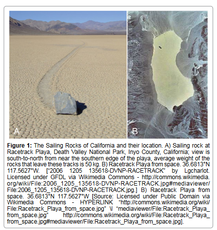
Figure 1: The Sailing Rocks of California and their location. A) Sailing rock at Racetrack Playa, Death Valley National Park, Inyo County, California; view is south-to-north from near the southern edge of the playa, average weight of the rocks that leave these tracks is 50 kg. B) Racetrack Playa from space. 36.6813°N 117.5627°W.
The essential preconditions for rocks to sail, if they do, are a nonadhesive surface for the block to glide on and some physical force moving them. Beyond this there exist several theories about how rocks actually move. At the Racetrack Playa of the Death Valley National Parc, California (Figure 1B), and the reduction of friction is guaranteed if the argillaceous surface of the former lake bottom (24% fine sand; 41% silt; 35% clay [14]) was saturated with water, and the swollen finematerial became almost fluidised. Both the movement of the blocks was thought to have been started by wind, as was the maintenance of their gliding [3,4]. Stanley in 1955, however, argued that the rocks were too heavy to be moved by the wind, and instead developed the idea that ice might be involved [5]. Five years later Sharp confirmed this hypothesis [15]. He developed a model calculation that, if dry mud is soaked with water, wind velocities of 33 m/s [75 mph] – 45 m/s [102 mph] would be necessary to move rocks in which the relation of their surface oriented towards the wind (Af) to their mass (m) is Af/m=20×10-3. These wind velocities, however, seemed not to be possible in the area under consideration. Bacon et al. discovered in 1996, however, at Owens Dry Lake Playa, that the boundary layers, where due to the high ground drag wind velocities are diminished, may be just as low as 2 inches (5.1 cm) in thickness. Thus the full force of wintry wind gusts impinges on the surfaces of the block, and the wind velocities can reach 90 m/h [140 km/h], much more than was calculated by former models [16]. Accordingly wind could indeed be the force for moving and sustaining the movement of the rocks. The lack of parallel runs between some rock paths, however, caused Easterbrook to start once more a discussion of the influence of ice, suggesting that degenerating ice floes would cause more randomised courses [17]. An alternative hypothesis was given by Wehmeier in 1986, who observed that the sliding stones on the Alkali Flat, Nevada, were moved by subaquatic, at least inaquatic sliding processes, while the driving force was not, or just occasionally the wind, but the hydraulic energy of surface runoff [18]. Furthermore it was postulated that ice rafts form around the blocks [10], reducing the specific weight of the entire system, and providing buoyancy lifting the rocks off the lake bed, acting as ‘rafts’ rather than as ‘sailors’, which were then driven by the winds over the plane surface [19,20]. This model was further developed by Kletetschka et al. in a laboratory experiment [21]. They were able to demonstrate, that under certain conditions a block becomes shifted upwards by a layer of ice which floats on the flowing, turbulent water underneath. The water needed for this system to work comes from the Racetrack mountain area, which drains into the Race Track Playa, building an ephemeral pond during winter times [21]. New GPS- and time-lapse analyses in 2014, however, finally disposed of this former ‘ice raft theory’. Norris et al. described rocks moving with a velocity of up to 5 m/min, for a distance of up to 240 m in multiple events between December 2013 and January 2014. They observed very thin ice crusts, involved in this movement. As soon as these start to melt, very low wind intensities (4-5 m/s) suffice to move the rocks. The underlying actual movement is caused by the weight of the system. The authors emphasise that the movement of the blocks is tied to prior precipitation in form of rain, or melting snow. The combination of all these preconditions can be realised during sunny noondays. At such times the surface of the iced ephemeral pond breaks into large ice shields, several tens of meters in diameter, but just few millimeters thick, and it is on these that the large rocks float, bulldozed by the ice panels at low speeds (2-5 m/min) across the Race Track Playa. They follow the direction and velocity of the winds as well as of the water flowing under the ice [10,22]. The combination of all these preconditions, however, is so rare, that it took such a long time to be discovered.
The phenomenon described here is that of a small quartzite-pebble, with its trace of movement on a bed of loess. It closely resembles a natural prototype of the large ‘Sailing Rocks’ of Death Valley in California and elsewhere, and an analysis may show whether it is indeed so, and whether there are similarities to previously described systems, which may allow a deeper understanding of this famous phenomenon in general.
The rock which seems to have ‘sailed’ here is a small piece of quartzite (Figures 2A-2F). It has a weight of ~5 (4.94) gram, and a diameter of approximately 2 cm (2.1 cm). The shape is basically that of an irregular, more or less triangular pyramid with rounded edges. One surface is roughly broken and directed backwards with regard to the direction of the track. This sharply margined surface indicates that the piece of quartzite formed part of a cracked piece of gravel, an element of the early Pleistocene Hauptterrase, the geological setting of the location. The pebble lies at the end of a flat track, as wide as the pebble itself. At the end of the track the pebble has sunk for about 7 mm into the mud, which corresponds to about 1/3 of its overall height.
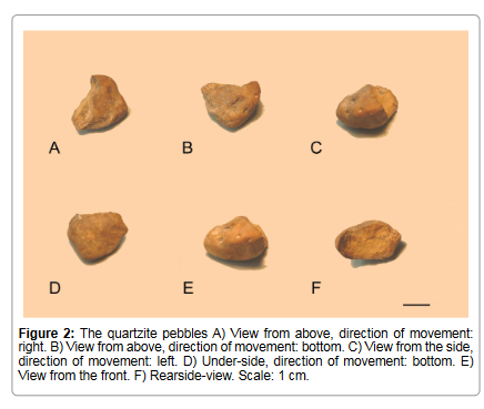
Figure 2: The quartzite pebbles A) View from above, direction of movement: right. B) View from above, direction of movement: bottom. C) View from the side, direction of movement: left. D) Under-side, direction of movement: bottom. E) View from the front. F) Rearside-view. Scale: 1 cm.
The trace is about 70 cm long. It runs on average towards the ESE, changing its direction slightly several times, while within these intervals the course is more or less straight (Figures 3A-3I). The trace is a flat imprint depressed about 0.3 cm into the ground, and margined on each side by a low wall of about 0.2 cm height. It starts with a single left wall, with regard to the direction of movement, which is joined by the second wall about 4.5 cm further on. Over the first ~14 cm the trace is wider than along the main course where it is constantly about ~1 cm wide. The initial width lies at about 1.4 cm and narrows over the following ~12 cm to stay of constant width from there on. The ground of the trace is homogenously flat over almost half of the way, where it starts to show a small central ridge, which widens from a few millimeters continuously until the ridge fills the entire trace at the end. During the last few centimetres (~10.5 cm) the contours of the shape become obscure and less discernible. The end of the trace is characterised by a second series of small walls of mud (~0.4 cm high, ~0.4 cm wide) embracing the pebble on two thirds of its extent.
Two slight imprints with the contours of the small rock can be distinguished almost in the middle of the course (Figures 3A and 3B), which may best be interpreted as ‘points of rest’ where the movement may have stopped for a while. Most remarkable are needle-like traces oriented more or less perpendicularly to the direction of the trace and at the side of it (Figure 3C). These ‘needles’ are hollow forms of different lengths and there are numerous instances of them crossing the trace. These straight unbranched forms have a length of up to 10 cm, starting with a width of ~0.1-0.2 cm and sharpen to a distinct tip at their end. They are typical marks of former frost on the ground.
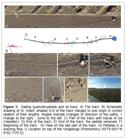
Figure 3: Sailing quartzite-pebble and its track. A) The track. B) Schematic drawing of A). Insert: phases A-G of the track merged to one origin in correct relation of their lengths. Angles indicate changes of direction of the paths, + change to the right, - turns to the left. C) Part of the track with traces of ice (‘needles’). D) End of the track. E) End of the track, the pebble removed. F) Beginning of the track. G) View on the last part of the track. H) Pebbles in a draining flow. I) Location on top of the Vorgebirge (Promotory) 50°74.9551’N 6°92.1170’ E).
After the pebble was removed from its end-position an ovaloid hollow form became visible; this was ~0.7 cm deep and had a diameter of ~2 cm. It becomes obvious that the outer ridge of mud is closed backwards, forming a ring. The closeness of this ring emphasises that there was no ice-collar around the small quartzite, and no rafting [17,19]. The otherwise homogenously flat ground of the hollow form displays a small dark stone (Ø ~0.4 cm) which may well have stopped the movement of the pebble (Figure 2E, arrow) and a larger one in the front. Because the track itself, however, becomes deeper and deeper towards the end (Figure 3G) secondly it is rather probable, that the ground became thawed so much that no solid underground to sail on existed anymore, and so the moving pebble stuck.
The phenomenon was observed and photographed (Panasonic Lumix HD, Leica DC Vario Elmar objective) on 1st January 2015, at 15.00 in the afternoon. The geographic position is N 50°74.9551’ E 6°92.1170’, on an asphalted track between fields (Figure 3I) southwards of Bornheim-Hemmerich, a village which is part of Bornheim, a small city between Cologne and Bonn in western Germany. The terrain lies about 160 m above sea level NHN, and thus approximately 100 m above the Rhine valley, some kilometers WNW-wards. The landscape is named Vorgebirge (Promontory), a tectonically uplifted plate (Erftscholle) with a sharply scarped edge, oriented NW to SE. Geologically this area belongs to an early Pleistocene Haupterrasse (~850.000a) [23]. The fluviatile sediments of gravel, mainly containing quartz and quarztites, are covered by an overlay of loess, which also covers the slope of the Vorgebirge. This loess is an predominatly silt-sized, aeolian sediment formed of particles in the 20-50 μm size range. The composition shows 20% or less clay (particle size<2 μm), silt (particle size>2 μm) and sand (particle size>63 μm) balanced in more or less equal proportions, loosely cemented by calcium carbonate [24-26]. Loess is a material which will swell under wet conditions, and shrink if it dries out, forming dessication cracks. In this area the loess from the fields is flushed by rain into the margins of the farm tracks (here asphalted) which are slightly domed in the middle. In these margins the flushed out fine material accumulates to form bands of some decimeters width and some centimeters depth. The surface of this Hauptterrassen landscape is part of the Erftscholle, which appears slightly undulating and is smoothly tilted southwest-wards towards the Eifel, a low mountain range country flanking the Rhine towards the west.
Weather conditions during the time when these observations were made were quite unusual. They probably happen not very often during a winter, and not every year. Because we describe a retrograde analysis, one has to rely on approximate indications, the more so since at this location there exists no separate weather station. When the photographs were taken on 1st January, it was a bright and sunny day (3 p.m.), the temperature (at 15.00) was 8.1°C. On December 28th, an Atlantic deep pressure system had approached over France, several millimeters of rain fell, at temperatures between 0 and 3C, accompanied by a fresh wind from east and strong squalls (40 km/h) (DWD 2015 [27]). The soils became saturated with water, and puddles stood everywhere in the fields. On the next day temperatures and rainfall were similar, but the wind turned to the north-east and decreased (max. 25 m/h). On December 30th during the night temperatures fell up to –10°C, during the day several centimetres of snow fell, and accumulated, and the ground was frozen. Temperatures over the day remained a few degrees below zero; the wind came now from the west with a speed of ~20 km/h. During the 31st of December the region came under the influence of a high pressure system from the west, there was some drizzling rain, air-temperatures reached 4 degrees with a moderate wind of 15 km/h, as during the next day the mean temperatures above ground were still below 0°C [mean temperatures above ground ranged between 28.12.2014 (-9.4°C) to -1.4°C (31.12.) and -2.2C (1.1), Station Bonn Roleber], (DWD 2015 [27]). On the 1st January the day was sunny, with no rain and with local temperatures up to 8 degrees. The wind was low from WNW, at about 15 km/h with sporadic low gusts (after my own observations and after data of Deutscher Wetterdienst, DWD 2015 [27]). Thus it is possible to reconstruct the preconditions on which the phenomenon was observed: The fine loess-soil had been swollen with water from drizzle and melted snow during the days before, while ground and surface were frozen until the later morning of the 1st January when sun warmed it up, so did the air as the sunlit ground became milder. There was a low wind from WNW with sporadic low gusts.
The trace (Figure 3) indicates that the small piece of quartzite had moved. The force that had caused it to move was most likely to have been inertia or wind, because no traces of animal or human forces are present, and there were certainly no ice floes large enough to have moved the pebble in this miniscule system. Also movements of small ice rafts have never been observed during the melting processes along these field track margins. Even more, physical properties of these systems conflict with the building of ‘ice collars’ around the blocks later forming ‘ice-rafts’, which have been observed several times at Racetrack Playa [14,19,20]. The thermal conductivity λ of rocks of dolomite, granite (Racetrack Playa) or quartzite (Vorgebirge) is some multitudes higher than that of water or loess [dolomite [0°C] λ: 11.9 [W/mK] [28], granite [average T] λ: 3.07 [W/mK] [28], quartzite [0°C] λ: 13.1-13.6 [W/mK] [28], loess and similar fine soil material λ: 29], water [0°C] λ: 0.56 [W/mk] [30]. In consequence the temperature of quartzite, granite or dolomite rocks follows any changes of the external temperature of air faster than does the sub ground. If the sun lights the rocks and surrounding ice, the rock will warm up and melt the substrate around, as is documented by examples in Figures 4A-4G. ‘Ice collars’ by these physical reasons can only be formed if the temperature falls, and lowers below zero, for example after sunset (Figure 4A). Because λ is a material property and not depending on the mass, small rocks as pebbles behave as big ones. This, however, means that the ‘ice rafts’ [19,20] must have been formed in a different way. One hypothesis could be that water which comes from mountains far away (Figure 1B) rushes downwards, flows under the ice, pushing the whole system upwards, while the iced surface breaks to ice floes, which still includes the big blocks. These water flows below the covering ice sheets may be another form of transport, as had been discussed earlier [17,18]. Wind may be a supporting force here of course.
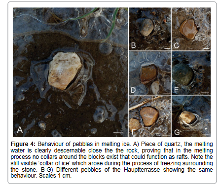
Figure 4: Behaviour of pebbles in melting ice. A) Piece of quartz, the melting water is clearly descernable close the the rock, proving that in the melting process no collars around the blocks exist that could function as rafts. Note the still visible ‘collar of ice’ which arose during the process of freezing surrounding the stone. B-G) Different pebbles of the Hauptterrasse showing the same behaviour. Scales 1 cm.
A number of preconditions of the small system described here, however, are very similar to those of the ‘sailing rocks’ in California and elsewhere. There is a solid sub ground – whether the asphalt of the road, or the deeply frozen fine-material, here consisting of spilled-out soil in the margin of the road. At the time when the phenomenon was observed (1.1., 15.00), the day was sunny with temperatures in the sun up to +8.1 °C at this location, and there was a slight wind from the NW.
It is important to state, that the pebble has behaved differently from normal, as Figure 3H indicates. Here is clear that during or after rain, or if the snow melts, small flushes flow along the margins of the roads, but the pebbles and small stones, sinking slightly into the ground, behave as obstacles, and are not moved by the water streams. They form the normal patterns of luv and lee in flows, but stay constantly in the same position (Figure 3H).
The author has lived in this area since more than 20 years, but has never observed such a phenomenon before, indicating that this event is very rare. Because it could not be observed in situ, it is necessary to formulate a hypothesis. The data of the Deutsche Wetterdienst [27] record that between 28th of December and 30th of December, several centimetres of snow had fallen [27]. The snow melted during the day of 31th of December, forming a water saturated soil system with ice and water puddles in the fields, but there was no sun that day, and the air ground temperatures were still below or slightly above zero (mean temperature air ground -1.4°, Bonn Roleber [27]). Due to the cold temperatures since 25th of December the soil in the trench was frozen through, and pebbles and small stones were incorporated into this system of frozen material. When the site was exposed to the sun on 1st of January, the system started to melt. Due to the difference in thermal conductivity of quartzite and wet soil, ice started to melt around the pebble, and then the surface of the frozen loess started to melt, forming a water-silt sheet above the ice-body of loess below. This water sheet first embraced the pebble, but finally even the level below the pebble started to melt as did the whole surface of the drained loess around, forming to a phase of silt and water on ice. This was the moment of lowest friction, while the deeper ground still was frozen and solid. Newton´s Law tells us that any force that acts on a mass evokes an acceleration. Because the direction of the trace changes, this force might not have been entirely inertia, which made the pebble move downwards the trench. Inertia had been a constant force, with constant direction and acceleration. Wind that day came from WNW and the flat rear side of the pebble was oriented towards the wind, probably acting as a kind of sail. Figure 3B (insert) shows that the driving force in all parts of the trace came from WNW, in an angular interval of less than 30°. This indicates that the total event happened in a short interval of time; probably the whole movement came up during a single day - the first of January 2015.
As previously noted, the track starts with just one wall, in the lee-side of the assumed wind force, indicating that the pebble was pressed against the material at one side. From there the track is quite straight, changing the directions slightly a few times, probably due to slightly changing wind directions they correspond to (Figure 3B). Two slight, almost circular imprints (Figures 3A and 3B), are probably best interpreted as ‘resting places’ of the small rock, where the movement was interrupted. The surface of the trace is homogenous, and more or less flat. In its last third it appears to deepen slightly up to its end. The process that generated this pattern can be explained by a continuously melting surface. The resting points originate when the wind slows down. In the beginning the deeply frozen ground did not melt deeply, it was just the first few millimetres depth that turned into a watery phase, thus the small quartzite could sail over a homogenously flat hard sub ground with low friction in a watery-icy phase, a transient thin layer, until the driving force, in other words the wind, calmed down. In the last part of the track (~10 cm), more evident turbulences in the ground of the trace can be observed. The increased temperatures of that day (8°C) in the early afternoon may have melted even deeper ground material rather quickly, thus the pebble sunk more and more into the ground, and any progression in the mud had to ‘fight’ with increasingly high resistance due to friction (Figures 3D,3E,3G). Finally the pebble met other small stones which could not be overridden, and so it became stuck (Figure 3E). This final part of the trace is only ~10 cm in length and is rather short in comparison to the rest. Because shorter distances seem to have been passed under constant wind conditions the pebble, by this stage, seems to have sailed more slowly. The force of the low winds pushing the small stone must have been comparatively effective, probably due to the low friction in the water-saturated fine-material of the ground, because distinctive bow waves arose at the end. In front of the pebble 2-3 rings can be seen, which accumulated as a result of movement of the pebbles. One of these rings encloses the pebble entirely, and clearly indicates a final sinking into the clay (Figures 3D and 3E).
The ‘Sailing Rocks’ of the Death Valley are known worldwide, and the enigma of how they move over a desert ground without intervention of animal or human forces remains puzzling. In the same way that prototypes of technical systems are often simpler, smaller, but nevertheless functional models of the final version of a product, the system described here of a small sailing quartzite-pebble looks like a natural prototype of the famous ‘Sailing Rocks’ of Death Valley in California and elsewhere. It shows that sailing rocks can appear at other places than desert lakes. The preconditions of the ‘Sailing Rocks’ and the ‘Sailing Pebble’ are almost identical. Both phenomena can be only rarely observed, and happen under unusual conditions: water-saturated soils with a high content of silt and clay, low winds and especially a ground with low friction because of a water-ice system on a sunny day after a longer period of frost. These low-friction surfaces, upon which gliding may occur, probably arise because of a water-ice system, which is comparable to the slippery interface of a skate melting the ice below a skid by the weight of the skater. The accelerating force in the pebble system is low wind, strong enough to move the small rock. If the pebble is resting on the ice-water interface and is exposed to a wind-force while the ice on which it sits is continuously melted by the sun, in any short interval of time the inertia of water below the rock is too high for all the water below it to be able to escape to the sides. In consequence the system rests on the layer of highly mobile molecules of a fluid, and can be shifted almost without any force. Because water is an incompressible fluid this system is independent of the weight of the block and is valid for pebbles, but also for the big rocks in the Death-Valley-system and elsewhere, as it is even for cars or large trucks of several tonnes weight on a thin wet surface on the hard subground of a road - a wellknown phenomenon which is termed aquaplaning. As reported before, noteworthy wind energy occurs in the mentioned desert areas, which starts and keeps the rocks moving. A track arises as soon as the layer of water-silt upon the iced ground is thicker than the interface icewater below the pebble/rock, as the walls of the trace are formed by material which could be pressed to the sides. Pushing ice floes might have been an additional factor, but are not necessary in the prototypesystem described. It is possible that melting water streams may have influenced the course, especially so in the systems of the large blocks in Death Valley because of their ‘ice collars’. These courses are difficult to explain otherwise. So, in conclusion, this miniscule system of a ‘sailing pebble’ shares the same minimum conditions with the large blocks, and it ‘sails’, but probably ‘sails’ under restricted conditions – with few or no floes underneath a covering ice sheet, no ‘ice collars’ embracing the small rock, but gliding on a low friction water-ice-silt interface in a kind of Aqua-Planing. In principle it may work in a similar way as the large systems do, but in a more restricted sense. It can be considered a natural, miniaturised prototype of the ‘sailing rocks’, and yet the stones sail.
We thank anonymous reviewers for their helpful comments, and Markus Muss for his support with meteorological data.
The author declares no competing financial interests.