Journal of Geology & Geophysics
Open Access
ISSN: 2381-8719
ISSN: 2381-8719
Research Article - (2024)Volume 13, Issue 3
The Ghadames Basin is a highly productive petroleum province with a long exploration history in Algeria, Libya and Tunisia (from the late 1950’s to present day). Ongoing exploration success in all three countries suggests that it will continue to provide attractive exploration targets in the future. A Regional N-S cross section through the Ghadames basin has been constructed to document and improve understanding of the geologic framework and petroleum systems of the Ghadames basin. It extends from the Mediterranean Sea in the north through the Jifarah Basin, Jabal Nafusah, Ghadames Basin and Alatshan high to northern part of the Murzuq basin in the south, covers approximately 700 kilometers and provides a regional view of the structural and stratigraphic framework of the Ghadames basin.
The information shown on the cross section is based on well logs data from thirty five wells, most of which penetrate the Paleozoic sedimentary rocks of the basin and two of which bottom in crystalline basement rocks. The correlation of stratigraphic intervals between the wells was based on a diversity of wireline logs and lithologic logs. The most commonly used logs were the GR (Gamma-Ray), SP resistivity and sonic logs. This cross section was generated by using LandMark StratWork software. Wells included in the section were chosen on basis of location, presence of all the section, depth of penetration and data availability.
The scope of this project was in the distribution of the key formations and looking for new potential areas especially in the north (Jifarah Basin). In terms of the hydrocarbon potential in the areas around Jabal Nafusah; the Tigi discovery are drawn attention for hydrocarbon exploration where all the petroleum system elements are presented; Reservoir rock: Tahara, Acacus, Mamuniyat, Ouled Chebbi and Ras Hamia formations. While source rock: Tanezzuft formation. Trap: Structural- unconformity trap. Seal: Mrar, Bir Al Jaja formation, Abu Shaybah as well as intraformational seals. Also there are another hydrocarbon potential in the basin Tahara and Mrar formations with possibility of stratigraphic traps.
Ghadames basin; Cross section; Exploration; Reservoirs; Mrar formation; Tahara formation
The intracratonic Ghadamis Basin is located in the northwestern part of Libya and stretches across eastern Algeria and southern Tunisia. The basin covers an area of about 350,000 km2; the maximum sedimentary-fill thicknesses (in Algeria) are approximately 7000 m. A regional N-S cross section through the Ghadames basin has been constructed to document and improve understanding of the geologic framework and petro-leum systems of the Ghadames basin. The N-S cross section extends from the Mediterranean sea in the north through the Jifarah basin, Jabal Nafusah, Ghadames basin and Alatshan High to northern part of the Murzuq basin in the south, covers approximately 700 kilometers and provides a regional view of the structural and stratigraphic framework of the Ghadames basin (Figure 1) [1].
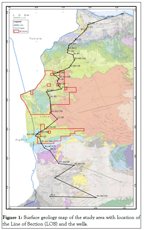
Figure 1: Surface geology map of the study area with location of the Line of Section (LOS) and the wells.
What’s more, this study will provide us with the potential areas for the future exploration programme in the basin. The information shown on the cross section is based on geophysical data from thirty five wells, most of which penetrate the Paleozoic sedimentary rocks of the basin and two of which bottom in crystalline basement rocks. Figure 1 shows the geological surface of the area of interested, where we can observe variety formations from north to south. The correlation of stratigraphic intervals between the wells was based on a diversity of wireline logs and lithologic logs.
The most commonly used logs were the GR (Gamma-Ray), SP (Spontaneous Potential), ILD (resistivity) and DT (sonic) logs.
The locations of the tops of each stratigraphic unit penetrated in the chosen wells were calculated the Total Vertical Depths (TVD) in meters (m) below Kelly Bushing (KB) and then plotted on the cross section. Detailed depth information for the tops of the stratigraphic units and unconformities in each well are reported [2].
This cross section was generated by using LandMark StratWork software. Wells included in the section were chosen on basis of location, presence of all the section, depth of penetration and data availability.
Scope of the study
The scope of this study is to give us a clear picture of the distribution of the key formations and looking for new potential areas especially in the north (Jifarah Basin).
Selected horizons and unconformities and their description
23 regional surfaces have been mapped and correlated in this work and they represented the main reservoirs, sources, seals and aquifers formation. Some of them included: Top Ordovician, top Silurian, top Devonian and top Triassic, where the ages of these horizons were taken from the previous work, consulting work and published papers. As well as, the unconformity surfaces in the Ghadames basin, the Jifarah basin, Alatshan high and the northern part of the Murzuq basin, such as Taconic, Austrian, Strunian, Hercynian, Frasnian and Caledonian unconformities [3].
The main criteria to pick the unconformity surfaces are the surface terminations such as truncation for example the Paleozoic section is truncated below the Hercynian unconformity.
Also they picked from the changes in the formation thicknesses throughout the area and based on and abrupt change in the lithology from continental to marine setting. Besides the interpreted formations, faults were also picked. The mapped horizons cover section ranging in ages from upper Cretaceous down to Ordovician periods. The most important horizons and their descriptions are listed from top to bottom in the Table 1 [4].
| Surface | Description of example lithosrtatigraphy formations |
|---|---|
| K80 | Qasar Tigrinah formation |
| K70 | Gharyan formation |
| K50 | Austrian unconformity and top Kiklah formation |
| K40 | Jadu Dolomite represents a good marker in the Ghadames Basin |
| K0 | Base cretaceous |
| J50 | Abreghs formation is top of the evaporate section |
| T90 | Abu Shaybah formation represents the top seal for the Ras Hamia |
| T75 | Ras Hamia formation is secondary reservoir in the Ghadames Basin |
| Ouled Chebbi | Potential reservoir rock in the Jifarah basin |
| Bir Al Jaja | Top seal for the Acacus formation in the Jabal Nafusah area |
| Hercynian unconformity | Separated the Paleozoic from Mesozoic sections |
| C70 | Dembaba formation (Carbonate rocks) |
| C50 | Assedjefar formation |
| C30 | Mrar formation |
| C0 | Strunian unconformity. Top of the Tahara formation, it is consider as a reservoir in some places |
| D75 | Awaynat Wanin formation; The top of the Awaynat Wanin is D80 (base Tahara) |
| D66 | Frasnian; above it is the second source rock in the Ghadames basin |
| D40 | Wan Kasa formation, upper part is a regional seal; lower part (below D25) is potential reservoir |
| D23 | Tadrart formation, reservoir unit |
| D0 | Caledonian unconformity its top of the Acacus formation |
| S75 | Middle Acacus shale act as a seal for the lower Acacus reservoir |
| S50 | Lower Acacus which represent of the main reservoir rock in the area |
| S25 | Tanezzuft formation: The basal section of this thick shale sequence is the main source rock in the area and cap rock for the Mamuniyat formation as well |
| S0 | Taconic unconformity, top of the Ordovician Mamuniyat formation (reservoir) |
Table 1: List of the selected surfaces.
Data sources and confidence
The primary source of the data was Libyan NOC (National Oil Corporation) well data base, as well as other sources such as consulting work, IHS website, published papers The majority of the well data are fairly old and data quality varies from poor, fair and in some areas good (Table 2). A vast amount of published information on the basin exists and was collected and used during the regional interpretations [5].
| Well name | Year | Main results | Reservoir | Data source | |||
|---|---|---|---|---|---|---|---|
| Well report | Well image | IHS website | Confidence | ||||
| A1-38 | 1970 | Dry | Acacus | X | X | X | Good |
| K1-23 | 1962 | Dry | Acacus | X | X | Fair | |
| J1-23 | 1962 | Dry | Acacus | X | X | Fair | |
| B1-23 | 1958 | Dry | Acacus | X | Poor | ||
| D1-23 | 1961 | Dry | Acacus | X | Poor | ||
| D2-23 | 1961 | Dry | Acacus | X | Poor | ||
| U1-23 | 1964 | Dry | Acacus | X | X | X | Good |
| A1-NC2 | 1986 | Oil and gas | Acacus | X | X | X | Good |
| T1-23 | 1964 | Oil | Acacus | X | X | Fair | |
| B1-61 | 1961 | Oil and gas | Acacus | X | X | X | Good |
| D1-NC118 | 1981 | Oil | Acacus | X | X | Fair | |
| A1-NC118 | 1985 | Oil and gas | Acacus | X | X | Fair | |
| V1-NC100 | 1985 | Oil and gas | Acacus | X | X | Fair | |
| Z1-NC100 | 1985 | Oil and gas | Acacus | X | X | X | Good |
| B1-NC100 | 1981 | Dry | Acacus | X | X | X | Good |
| J1-26 | 1963 | Dry | Acacus | X | Poor | ||
| D1-26 | 1960 | Oil | Ras Hamia | X | Poor | ||
| I1-26 | 1962 | Dry | Acacus | X | Poor | ||
| B1-90 | 1964 | Dry | Acacus | X | X | X | Good |
| A1-90 | 1964 | Dry | Acacus | X | Poor | ||
| A1-NC179 | 1997 | Oil and gas | Acacus | X | X | X | Good |
| L1-26 | 1964 | Dry | Acacus | X | X | X | Good |
| A1-NC55 | 1977 | Dry | Acacus | X | X | Fair | |
| A6-NC169 | 1993 | Oil | F3 Sand | X | X | Fair | |
| A1-NC169 | 1991 | Gas | F3 Sand | X | X | Fair | |
| A11-NC169A | 1997 | Dry | F3 Sand | X | X | Fair | |
| A1-52 | 1958 | Dry | Acacus | X | X | Fair | |
| C1-NC169 | 1997 | Dry | F3 Sand | X | Poor | ||
| A1-NC175 | 1997 | Gas | Mamuniyat | X | X | X | Good |
| M1-1 | 1964 | Dry | Mamuniyat | X | X | X | Good |
| K1-1 | 1964 | Dry | Mamuniyat | X | X | X | Good |
| A1-NC147 | 1988 | Dry | Acacus | X | X | X | Good |
| A1-NC151 | 1994 | Gas | Mamuniyat | X | X | Fair | |
| G1-1 | 1958 | Dry | Mamuniyat | X | X | X | Good |
| G1-NC151 | 1998 | Dry | Mamuniyat | X | X | Fair | |
| A1-1 | 1957 | Dry | Mamuniyat | X | X | X | Good |
Table 2: List of the available well data.
A regional north-south cross section
The Ghadames, Murzuq and Jifarah basins are filled with thick sedimentary Paleozoic sequences: Cambro-Ordovician, Silurian, Devonian and Carboniferous clastic rocks with some carbonate in the Upper Carboniferous which are covered by continental to shallow marine Mesozoic (Figure 2). The stratigraphy column can be divided into two intervals, Paleozoic and Mesozoic, separated by the Hercynian unconformity. The N-S cross section shows the variations in formation thicknesses from north to south as follows:
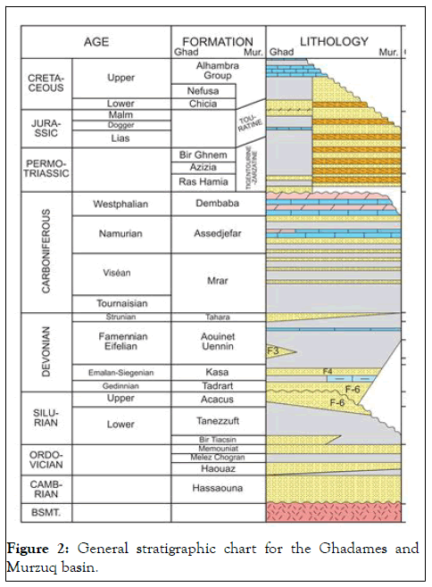
Figure 2: General stratigraphic chart for the Ghadames and Murzuq basin.
Cambrian and Ordovician sections
The Cambrian section is not penetrated along this section and the Ordovician section is penetrated by several wells.
Two wells A1-1 and A1-NC151 located south of the BP block B have a complete section (about 400 m thick) [6].
Silurian section
It is mainly a sequence of marine shale and sandstone represented by two formations, the Tanezzuft Shale and Acacus Sandstone. The sequence is similar across the entire Ghadames Basin to the north and into the Murzuq Basin to the south [7].
• Lower Silurian Tanezzuft formation; its present throughout
the basin except in the wells A1-38 and K1-23 where this
formation is not penetrated. The formation varies in thickness
throughout western Libya with the greatest thicknesses
occurring in the Ghadames Basin with a maximum thickness
about 500 m in the well A1-90, but it’s thinning southward in
wells G1-NC151 and A1-1 (about 100 m thick). This section
contains the hot shale (the lower unit) which represented the
main source rock in the area.
• Middle-upper Silurian Acacus formation; this formation is
present throughout the area with a thickness of about 560 m
in the basin centre. Its affected by two unconformity surfaces;
Caledonian unconformity to the south where the thickness of
the formation decreases to the south and absent in the well
A1-1 and truncated below the Hercynian unconformity to the
north in the area around Jabal Nafusah.
• In terms of petroleum potential the Acacus formation
represent the main reservoir rocks in the Ghadames Basin.
Whereas it’s less active south ward where the seal section is
not present and the formation is overlain by sandstone of the
Tadrart formation. Also this formation is produced to the
north in area around Jabal Nafusah the formation with
structural-unconformity trap. Further to the north in wells
A1-38 and K1-23 this formation is not penetrated.
Devonian section
The Devonian section is affected by three unconformity surfaces; Frasnian, Strunian and Hercynian unconformities, the first two led to thinning of the section to the south while the formation is truncated underneath the Hercynian unconformity to the north. This section includes the Tadrart, Wan Kasa Awaynat Wanin and Tahara formations. The Frasnian source rock represents the second source rock in the area as well as many reservoir intervals were presented in this interval.
The depositional facies in the section start with Fluvial Tadrart formation to shallow marine environments in the upper parts of the section (Figure 3) [8].
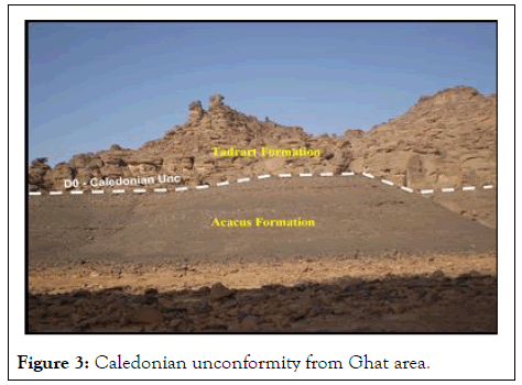
Figure 3: Caledonian unconformity from Ghat area.
Carboniferous section
In the Carboniferous age we have different story, where the thickness of this is massive (about 1000 m thick). The Carboniferous consists of three formations, the Mrar, Assedjefar and Dembaba that show a progression from deeper to shallowwater environments. The Carboniferous section is truncated below the Hercynian unconformity to the north, while to the south the upper section is eroded and the lower section is exposed at the surface [9].
Mesozoic Triassic section
The Mesozoic section is present in most parts of the Ghadames Basin and its more complete and thicker to the north. Further to the north in the Jifarah Basin the Mesozoic section becomes very thick (about 2000 m thick in the wells K1-23 and A1-38). This dramatic change in thickness of the section from south to north might be due to structural dominated especially in the Nafusah high area. The section is overlain by the tertiary and quaternary deposits [10].
To the north in the Jifarah Basin there are several large faults and they have huge effects on the thickness of the Triassic (Ouled Chebbi and Ras Hamia formations) and Jurassic (Abu Shaybah formation) sections. The section also shows the effect of syn-depositional faulting during the Triassic and the dramatic thickening of the Triassic formations towards the north.
The Mesozoic section characterized by changes in lithologies from continental deposits of Ouled Chebbi and Ras Hamia formations in the early Triassic to marine carbonates and evaporates Sabkhah deposits of the Alaziziah and Abu Shaybah formation of the late Triassic. During the Jurassic thick sections of shallow marine evaporate and a dolomite deposit of the Bir Al Ghanam and Abregh formations was deposited [11].
The thickness of the section also has dramatic change northward. Later in the Cretaceous this section was extended in the area from the Nafusah high in the north to the southern edge of the BP s block B in the south. This section is characterized by constant thickness and it’s exposed in the north and the south. The lithology of the section was varied from clastic deposits in the lower section to shallow marine carbonates and evaporates in the upper section (Figure 4).
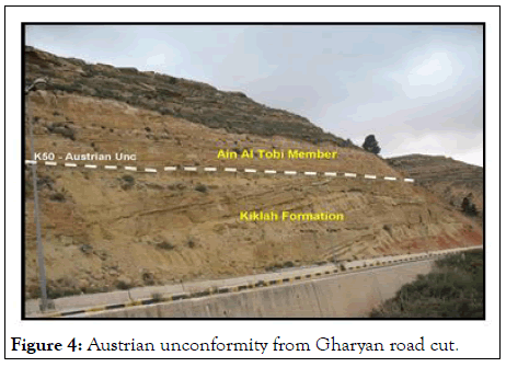
Figure 4: Austrian unconformity from Gharyan road cut.
Implications to HC potential in the Ghadames basin and the northern areas around Jabal Nafusah
There is more HC potential in the Ghadames basin, but in this study we focusing on the Tahara (Late Devonian) and the Mrar (Early Carboniferous) formations are two potential units for potential exploration in the basin (Figure 5).
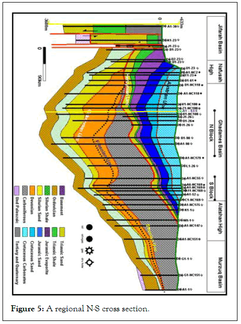
Figure 5: A regional N-S cross section.
Tahara formation potential and field examples
The Tahara formation is producing in the Gazeil trend and Al- Hamra trend which located east of the Ghadames basin (Figure 6). In addition, the well D1-26 in the BP block B has been tested in the Tahara formation with 280 bopd. The cross section illustrates that the Tahara formation pinches out to the north of the BP block B [12].
This formation is located above the second source rock in this area (Frasnian shale). The well correlation between V1-NC100 and A1-NC118 wells is critical and it possible to interpret an alternative erosional truncation model for the Tahara formation (Figure 7).
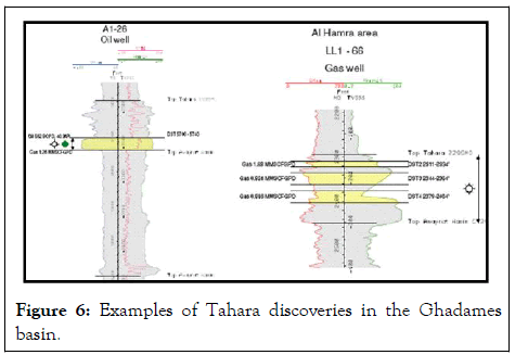
Figure 6: Examples of Tahara discoveries in the Ghadames basin.
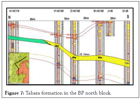
Figure 7: Tahara formation in the BP north block.
Mrar formation potential and field examples
The second reservoir unit which may be act as a potential for hydrocarbon exploration in the Ghadames basin is the Mrar formation, where the formation contains a series of sand bodies. These sand bodies occur inside the marine shale can be interpreted as channels. The good example of this formation is Zarzaitine field in Algeria (Figure 8).
Significant oil shows on test were obtained in the Mrar formation from A1-NC6 well with 460 bop/d of 37° API oil. On the Tanarat trend, oil and gas shows are described. The M1-26 well gave 211bop/d from a net pay of 5 m. The well M2-NC7A gave some gas. The lower Mrar reservoirs are mainly gas bearing in south western Libya in the Alatshan field with B1-1 well and with A1-1, C1-1, D1-1 wells and recently with A1-NC175 well. The maximum gas flow, observed in DST, reached 0.8 mmcfg/d in the B1-1 well. Gas in the Mrar formation was recorded in wells HH1-NC7A, A13-NC7A, M1-26, M2-NC7A and D1-26. In the Carboniferous, fluorescences and weak oil shows are reported in many wells, in the basin. Gas production from the Carboniferous in NC151 block amounts to 10 mmcfg/d.
In those fields the hydrocarbons are produced from the isolated sand bodies. In the Libyan Ghadames Basin we have similar succession (Figure 9), so we should look for this formation as a potential target. It’s not clear how these sand bodies are sourced. The log profiles for the Mrar sand bodies is clearing up and have a shallow water depositional setting it is may be in hence. However, it is critical to establish the correlation of the Carboniferous (Mrar) basin. If this is south of the BP acreage then up dip pinchout play is possible [13].
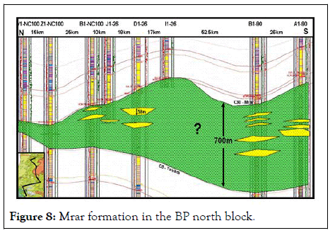
Figure 8: Mrar formation in the BP north block.
Mamuniyat formation potential and field examples
Until recently the Mamuniyat formation is not penetrated north areas, Many well have been drilled by Medco Company in the 47 area north-east of the BP north block and they produced gas from the Mamuniyat formation. The Mamuniyat formation is present throughout the area and the thickness of this formation is about 400 m in the well G1-NC151 in the south but to the north in the Ghadames Basin not many wells penetrated the section and all of them penetrated the upper section. Also this formation is present in the Jifarah Basin area in the K1-23 and B1-23 wells.
Further to the north the formation isn’t penetrated and may be deep if present at all. In the northern area around Jabal Nafusah two discoveries have been made; Tigi and NC1 discoveries which produced from Acacus formation. The trap mechanism in these fields is structural-unconformity trap, where the hydrocarbons are trapped in the subcrop of the Acacus formation truncated on the Hercynian unconformity (Figure 9).
It is likely to be further examples of this play type which could be present in the basin. In addition the west portion of the Tigi Filed there is a small gas discovery in well A1-23 (not present in the cross section) which produces from Ouled Chebbi formation with 10,000 Mscf/d. To the north of the Tigi discovery in the wells J1-23 and B1-23 the thickness of the Paleozoic section about 500 m thick, where the Acacus formation is absent and Tanezzuft and Mamuniyat formations are present at depths 1252 m and 1433 m respectively.
The thickness of the Paleozoic section is about 725 m thick at well K1-23 17 km north of the J1-23 well. However, the lithology in this part is undifferentiated. The well report, shows, core and cutting data were not exist just well image is available the key K1-23.
In addition, the fault between the K1-23 and J1-23 wells make the correlation between these wells difficult. As a result of the Hercynian unconformity has been displacement by 1000 m by this fault. Further to the north in the well A1-38 the Paleozoic section has not been penetrated. In terms of the hydrocarbon potential in the areas around Jabal Nafusah the areas east, west and north of the Tigi discovery are drawn attention for hydrocarbon exploration where all the petroleum system elements are presented.
• Reservoir rock-Acacus, Mamuniyat, Ouled Chebbi and Ras
Hamia formations.
• Source rock-Tanezzuft formation.
• Trap-structural-unconformity trap.
• Seal-Bir Al Jaja formation, Abu Shaybah as well as
intraformational seals.
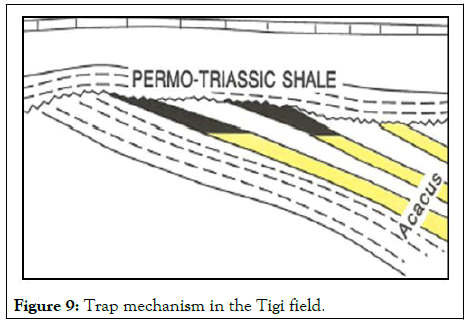
Figure 9: Trap mechanism in the Tigi field.
Further to the north and as a result of the faults most of these elements are missing and Figure 10 is a simple model explains why there aren’t new discoveries toward the north of the Tigi field. Figure 10A shows the entire cross section after removing fault displacement in the area. So there is a possibility to find the Tanezzuft and Mamuniyat formations north of the J1-23. But as a result of the faults the Tanezzuft and Mamuniyat formations are shifted deeply down or may be absent (Figure 10B).
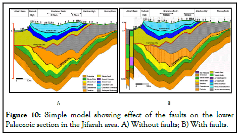
Figure 10: Simple model showing effect of the faults on the lower Paleozoic section in the Jifarah area. A) Without faults; B) With faults.
The cross section constitutes the control grid of interwell correlation and presents the greatly variable paleomorphology across the study area. The present distribution of sediments in the Ghadames Basin is the result of Taconic (Ordovician), Caledonian (end Silurian), Frasnian, Saurian (Late Devonian) Hercynian (end Carboniferous/early Permian) and Austrian (Aptian) tectonic events. The Tahara and Mrar formations have not been sufficiently explored and studied yet, particularly in the central part of the basin, where the sandstone units in the Tahara and Mrar formation could provide a good opportunity to explore for stratigraphic traps.
These intervals are recommended for study in more details in the future using all the available information. The exploration results in the Tigi and NC1 fields suggest that the equivalent structural-unconformity trap in the Acacus formation might also be prospective in the area around Jabal Nafusah. This interval should be studied in detail in the future using all the available information. The new Medco discoveries in the Mamuniyat formation give us re-new interest for future hydrocarbon exploration. In addition, the formation is present in the well J1-23 in the Jifarah Basin.
Add the biostratigraphic correlation data point to the cross section. Study Mrar and Tahara formations in details.
Citation: Emhanna S (2024) A Regional North-South Cross Section through the Ghadames Basin and its Implications to HC Potential in the Ghadames Basin and the Northern Areas around Jabal Nafusah. J Geol Geophys. 13:1175.
Received: 18-Mar-2020, Manuscript No. JGG-24-3661; Editor assigned: 23-Mar-2020, Pre QC No. JGG-24-3661 (PQ); Reviewed: 06-Apr-2020, QC No. JGG-24-3661; Revised: 03-Jun-2024, Manuscript No. JGG-24-3661 (R); Published: 30-Jun-2024 , DOI: 10.35248/2381-8719.24.13.1179
Copyright: © 2024 Emhanna S. This is an open-access article distributed under the terms of the Creative Commons Attribution License, which permits unrestricted use, distribution, and reproduction in any medium, provided the original author and source are credited.