Journal of Geography & Natural Disasters
Open Access
ISSN: 2167-0587
ISSN: 2167-0587
Research Article - (2023)Volume 13, Issue 3
This paper presents the impact assessment of ground fissuring in rift margin districts of Siltie Zone in southern Ethiopia, which is located at the western margin of the central portion of the Main Ethiopian Rift. Field investigations, literature reviews and interviews were employed in the study. Faults are the major structural units in the area shaping the landscapes as well as determining the size and positions of recent alluvial deposits. The geology of the area is made of rhyolitic ignimbrites at the bottom followed by basalts, and scoria cones are also common. Overlying this stratigraphy are thick unconsolidated alluvial deposits, at places reaching up to 70 m and filling grabens created by the regional faulting. Almost all the settlements and agricultural practices are concentrated on this fertile recent sediment. The area is frequently affected by ground fissuring that mainly occur as vertical cracks and ranges from discontinuous hairline fractures to open ground cracks up to 1200 m long, as much as 0.5 m to 6 m wide, and up to 5.2 m deep. The fissures are aligned in NNE-SSW directions, the average strike being N16°E. Manmade structures such as homes, water pipelines and storage tankers are destroyed by the fissuring. Agricultural lands and trees are also severely damaged. This heavily affected the food security in the districts since most of the residents are farmers. Some extensions of the fissures however are not exposed to the surface rather formed underground caves and sinkholes and will be future dangers in the area and need proper buffering.
Ground fissure; Main Ethiopian rift; Siltie Zone; Impact assessment; Rift margin; Unconsolidated sediments
Ground fissure is a tensional geological structure and geo-hazard which occurs on the surface of the earth. It is a progressive geological disaster which develops slowly and happened in many countries of the world such as the USA, Mexico, Japan, China, and many countries in East Africa [1,2]. The quantitative description parameters of ground fissures are variable and can attain kilometers of length and may have a depth reaching up to aquifers [3]. The possible causes of ground fissures can be grouped in to three categories: (1) natural reasons such as earth quakes, heavy rain fall, natural groundwater level fluctuation, and other crustal tectonics; (2) man-induced effects like groundwater over pumping, civil engineering works, and underground mining activities; and (3) the combined effect of any of the above factors. Field observations and literature indicate that ground fissuring has brought varieties of casualties on man and property. Some of the more common worldwide damages of ground fissuring include collapse of infrastructures (buildings, roads, water pipelines and irrigation canals), loss of fertile agricultural land, contaminating groundwater aquifers, disrupting drainages and associated sudden flooding, sudden discharge of pond water, human and animal injury or death [3-8].
The Main Ethiopian Rift (MER), which forms the northern part of the East African Rift, is the continental extension of the Afar Triple junction; the other two oceanic arms are the Red Sea and Gulf of Aden. It connects the Afar depression at Red Sea-Gulf of Aden junction with the Turkana depression and Kenya Rift to the South [9]. MER is characterized by extensional tectonics whose effects are manifested mainly through faults, earthquakes and volcanism. Consequently, ground fissures are one of the commonly encountered geo-hazards in the MER [10]. The present study area, Siltie Zone, is located at the western margin of the central MER as shown in Figure 1 and there have been reports by the local residents about the occurrence and adverse effects of ground fissuring in different localities. To date no comprehensive study has been conducted to assess the damages associated with ground fissures in this area.
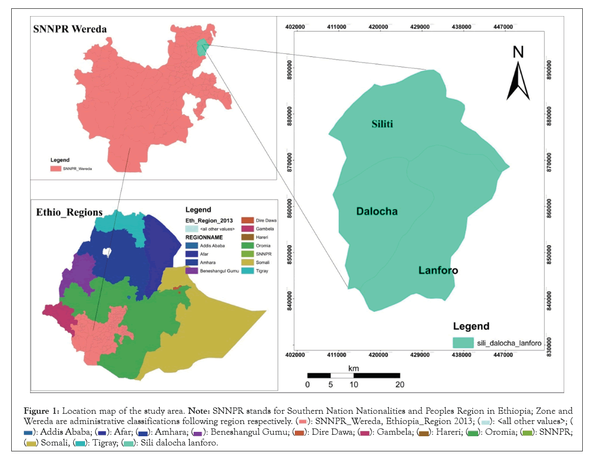
Figure 1: Location map of the study area. Note: SNNPR stands for Southern Nation Nationalities and Peoples Region in Ethiopia; Zone and Wereda are administrative classifications following region respectively.


The aim of this paper is therefore to assess the impacts of the ground fissuring in these rift margin Weredas of Siltie Zone such as Dalocha and Silti so that the local government authorities, development organizations, investors, and the public in general will consider the effects of ground fissures in their development work plans.
Detail field investigations, literature reviews and interviews with the local people were employed to assess the impacts of the ground fissuring in the study area. The field investigations were mainly conducted to understand the characteristics of the ground fissures. Ten traverse lines (5 in Dalocha Wereda and 5 in Silti Wereda) were prepared on topographic maps along the lengths of the fissures. Then, the lengths, widths, and depths of the ground fissures at different sites were measured using tape meter. The strikes of the fissures are determined using field geological compass. About 75 interviews were made with the local residents to understand the detailed impacts of the ground fissuring.
Regional geology
The present study area is part of the MER, a place where worlds’ classical volcanism is taking place such as the Afar region as shown in Figure 2. Igneous rocks of various composition and different ages are widespread in the region. The stratigraphy of the MER was briefly presented by Corti [9]; Abbate et al. [11] and references therein. Accordingly, an older (11 to 8 Ma) lower basalt unit with trachybasalts and subordinate silicic flows form the lower volcanic stratigraphy. These units are followed by extensive coverage of ignimbrites ranging in age from 7 Ma to 2 Ma. The next units which are limited to the northern and central sectors of MER are the Late Pliocene basalts with pyroclastics fed by calderas. Then it follows Quaternary basalt flows, scoria cones and large silicic central volcanoes which are associated with the oblique Wonji fault belt [11].
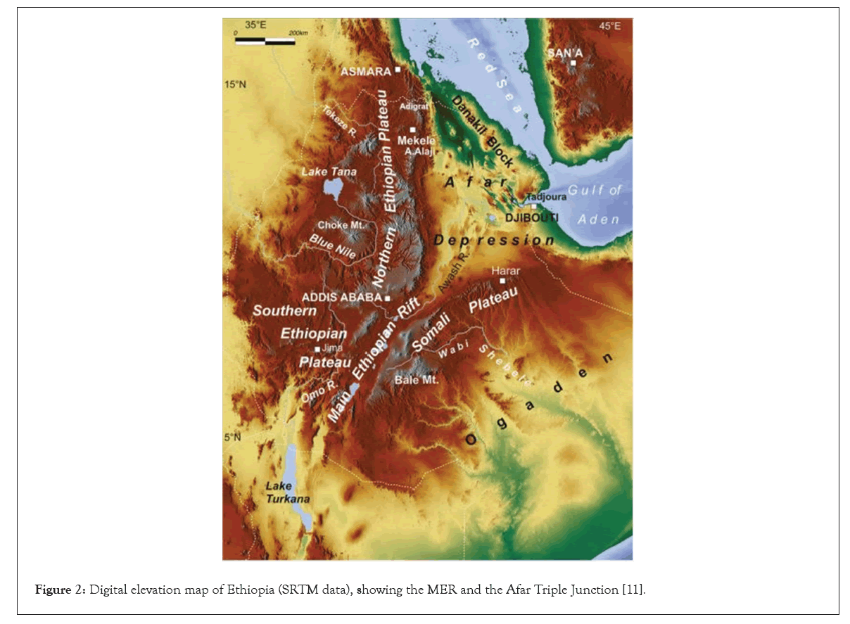
Figure 2: Digital elevation map of Ethiopia (SRTM data), showing the MER and the Afar Triple Junction [11].
Geology of the study area
As it is the case in most parts of the MER, normal faults are generally the dominant structural elements which shaped the land scape and distribution of different volcanic rocks and accumulations of alluvial deposits. Many local horst and graben structures are formed as a consequence of the faulting. The grabens were then filled with thick recent unconsolidated alluvial deposits, at places reaching up to 70 m. Most of the settlements and agricultural activities are concentrated in this fertile alluvial deposit as shown in Figure 3. Some eroded gullies and cracks demonstrate the presence of basalts just below the sediments. Scoria cones are also very common. These associations are probably correlated with the regional Quaternary volcanic units that are generally termed as the Wonji group. Further deeply eroded parts and quarries indicate the presence of rhyolitic ignimbrites of various degrees of welding.
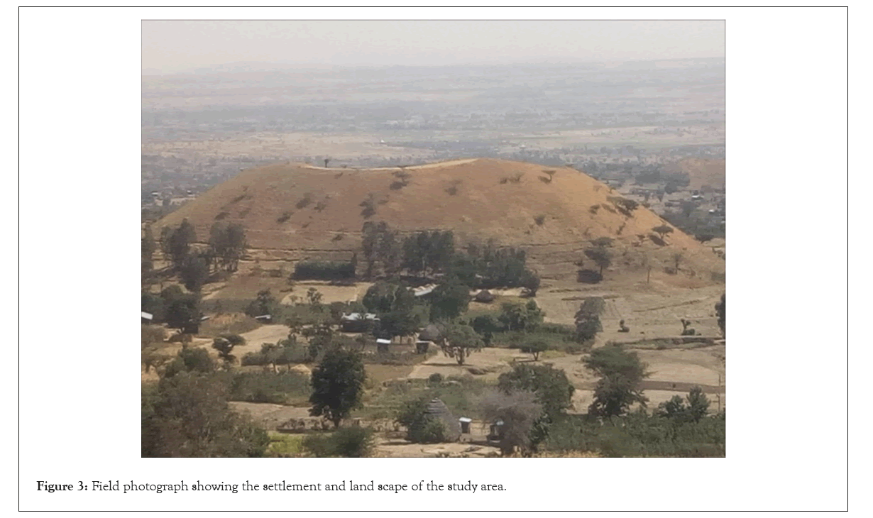
Figure 3: Field photograph showing the settlement and land scape of the study area.
Occurrence and characteristics of the ground fissures
As reported by the local residents and according to our field observations in different periods, repeated ground fissuring had occurred in the area such as the May 2016, April 2018, and May 2019. Although many works indicate that the causes of ground fissuring in the MER are related with the regional tectonics, the locations of the fissures and the seasons on which the fissures are formed in the study area however suggests that the possible causes will be the combined effects of aquifer compaction and heavy rain fall [10,12]. Firstly, all the observed ground fissures are found to be concentrated in the alluvial plains that filled the grabens created by the faulting in the region. Such fissures in alluvial basins are mainly caused by tensional forces related to differential land subsidence, which is mainly related to long-term groundwater pumping in excess of aquifer [6]. Congruent to this, the aquifers of the study area are the alluvial deposits and this is testified by the depth and presence of numerous groundwater wells. Surveys of many groundwater wells indicate their depths are between 30 m to 70 m which is within the thickness range of the unconsolidated sediments in different places. Secondly, as depicted in Figure 4, there are two rainy seasons in the area: from March to May and July to September. From October to February, the study area experiences very dry seasons and this cause extreme decline of groundwater levels in wells if not dry out at all. As a result, the voids of unconsolidated sediments in the area which were filled with water become empty due to groundwater decline and then followed by the heavy rain falls of March to May and this probably bombarded these unoccupied pores in the unconsolidated sediments and created the fissures as shown in Table 1.
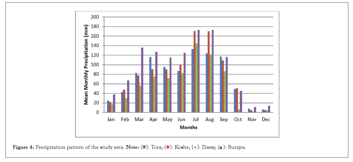
Figure 4: Precipitation pattern of the study area.
| Station | Recorded period | Location (UTM) | Mean Monthly Precipitation (mm) | ||||||||||||
|---|---|---|---|---|---|---|---|---|---|---|---|---|---|---|---|
| Longitude | Latitude | Jan | Feb | Mar | Apr | May | Jun | Jul | Aug | Sep | Oct | Nov | Dec | ||
| Tora | 1974-2004 | 436647 | 868906 | 25 | 43 | 83 | 116 | 95 | 87 | 133 | 124 | 117 | 49 | 8 | 6 |
| Koshe | 1974-2004 | 448183 | 884908 | 22 | 48 | 78 | 91 | 90 | 100 | 171 | 170 | 109 | 51 | 5 | 5 |
| Ziway | 1970-2004 | 468771 | 876858 | 17 | 30 | 56 | 75 | 72 | 83 | 145 | 122 | 86 | 6 | 2 | 4 |
| Butajra | 1968-2004 | 431353 | 897207 | 38 | 67 | 136 | 127 | 115 | 125 | 173 | 173 | 116 | 45 | 11 | 14 |
Table 1: Rainfall data of selected meteorological stations around the study area [13,14].
Although there is heavy rain fall from July to September, no further ground fissuring had been recorded in the area probably suggesting that this time the voids in the sediments are already filled with water due to the previous rainy seasons and the groundwater level rises up if not intersect the surface at places. Therefore, rainfall in these periods has no role in the creation of ground fissures except widening and deepening of the available cracks due to surface runoff.
Majority of the ground fissures in the area occur as vertical cracks. However, in some sites fissures which follow a normal listric fault fashion are also encountered as shown in Figure 5. The sizes of the ground fissures range from discontinuous hairline fractures to open ground cracks up to 600 m long, as much as 0.5 m to 6 m wide, and up to 4.2 m deep as shown in Table 2. However, the actual depth is greatly reduced due to the collapse of ceilings and walls of the cracks and difficult to exactly determine from field observations and measurements. Many of the fissures observed show vertical offsets. Field observations indicated that all the fissures are aligned NNE-SSW directions, the average strike being N16°E.
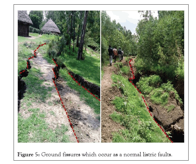
Figure 5: Ground fissures which occur as a normal listric faults.
| Site Number | Length (m) | Average width (m) | Average depth (m) | Average vertical offset (m) |
|---|---|---|---|---|
| DL01 | 1200 | 0.5 | 1.72 | 0 |
| DL02 | 570 | 3.6 | 2.4 | 0 |
| DL03 | 602 | 2.6 | 3.1 | 0.73 |
| DL04 | 382 | 0.52 | 1.62 | 0.34 |
| DL05 | 587 | 5.3 | 5.2 | 0.21 |
| SI01 | 481 | 3.4 | 3.7 | 0 |
| SI 02 | 560 | 6 | 3.2 | 0 |
| SI 03 | 541 | 4.71 | 4.3 | 0 |
| SI 04 | 581 | 6.02 | 2.9 | 0 |
| SI 05 | 497 | 1.2 | 3.5 | 0 |
Note: DL: Refers to fissuring sites in Dalocha Wereda; SI: Refers to fissuring sites in Silti Wereda.
Table 2: The sizes of ground fissures in selected sites of the study area from surface observations.
The impacts of the ground fissures
During the field survey, it is observed that the ground fissures had created many damages. The foremost problem that the ground fissure has caused in the study area is destruction on manmade structures such as homes, water pipelines and storage tankers. Figure 6a shows the local peoples traditional house which is damaged by fissuring and whose inhabitants are evacuated due to the May 2019 ground fissuring in the area. Figure 6b further illustrates the destructions caused at the interior of this house and the vertical offsets on the floor of the house. The ground fissures also brought severe damages on groundwater wells, water storage tankers, and water transmission pipelines as shown in Figures 6c and 6d. Interviews made with the local residents indicate many people do not get drinking water in their locality due to destruction of water lines by the fissures and as a result people are traveling long distances to get potable water.
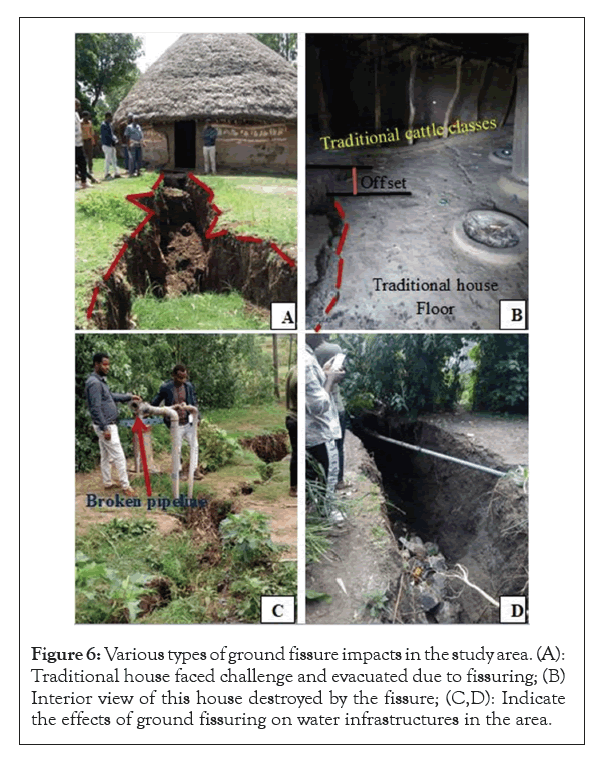
Figure 6: Various types of ground fissure impacts in the study area. (A): Traditional house faced challenge and evacuated due to fissuring; (B) Interior view of this house destroyed by the fissure; (C,D): Indicate the effects of ground fissuring on water infrastructures in the area.
Agricultural lands and trees are another elements destroyed by the ground fissuring in the area. Alluvial plains with thick fertile soils that are used for faming by the local people are severely damaged by ground fissuring at different sites as shown in Figure 7a. The most problematic aspects of the fissuring are that their widths as well as depths are further increasing due to erosion and they are destroying more and more farm lands. Reports from the local authorities as well as our field observation revealed that so far many hectares of farm land has been out of use due to the repeated occurrence of ground fissuring. This challenged the food security in the district since almost all the residents are famers engaged in cultivation of crops such as sorghum and maize. It is also very common to see fallen, dried and buried vegetation including long tree as shown in Figures 7b and 7c. Besides loss of trees which were used for different purposes by the local people, this has multiple effects including desertification, flooding, and destruction of electric lines when trees fall.
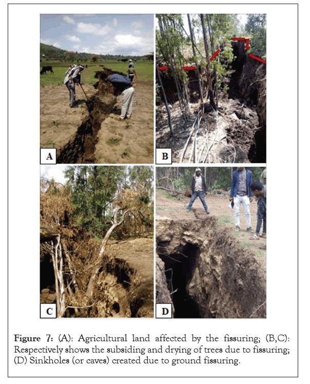
Figure 7: (A): Agricultural land affected by the fissuring; (B,C): Respectively shows the subsiding and drying of trees due to fissuring; (D) Sinkholes (or caves) created due to ground fissuring.
Since majority of the ground fissures are open due to collapse of their ceilings, they brought injury on people and death of animals. We observed cattle with legs broken due to falling in to the fissures. Some parts of the fissures are currently not opened and they are accompanied with sinkholes or caves along their lengths as shown in Figure 7d. Such underground voids are future risks in such populated districts because they may disintegrate due to heavy rain seasons. Since the unconsolidated sediments on which the fissuring is located are aquifers in the area, there will be probability of groundwater contamination because ground fissures can serve as conduits to direct recharge for pollutants to deep aquifers.
In this study, the overall impacts of ground fissuring in rift margin areas of Siltie Zone, namely Dalocha and Silti weredas were assessed through field investigation, literature reviews and interviews. The following conclusions are drawn based on this study:
• All the fissures are concentrated in unconsolidated deposits and mainly occur as vertical cracks with variable dimensions.
• The possible causes of the fissures are aquifer compaction followed by heavy and prolonged rainfall.
• The major impacts of ground fissuring are damage on man-made structures (houses, roads, water transmission lines, and storage tankers), destruction of farmlands and vegetation, evacuation of people, injury on human and other animals.
• There are underground caves and sinkholes formed due to unexposed ground fissures and probably will collapse in the future and create further damages.
Werabe University is gratefully acknowledged for arranging transportation facilities during the field work sessions of this research work. The author is also grateful to Solomon Umer and Temam Argaw for their support during field works. Abdulmejid Mohammed is deeply acknowledged for his support during mapping.
Citation: Ridwan M (2023) Assessment of the Impacts of Ground Fissuring in the Main Ethiopian Rift: The Case of the Rift Margin Areas of Siltie Zone, Southern Ethiopia, East Africa. J Geogr Nat Disasters. 13: 279
Received: 18-Jul-2023, Manuscript No. JGND-23-25742; Editor assigned: 21-Jul-2023, Pre QC No. JGND-23-25742 (PQ); Reviewed: 07-Aug-2023, QC No. JGND-23-25742; Revised: 28-Aug-2023, Manuscript No. JGND-23-25742 (R); Published: 04-Sep-2023 , DOI: 10.35841/2167-0587.23.13.279
Copyright: © 2023 Ridwan M. This is an open-access article distributed under the terms of the Creative Commons Attribution License, which permits unrestricted use, distribution, and reproduction in any medium, provided the original author and source are credited.