Journal of Information Technology & Software Engineering
Open Access
ISSN: 2165- 7866
+44 1300 500008
ISSN: 2165- 7866
+44 1300 500008
Research Article - (2019)Volume 9, Issue 1
Malaria is a significant public health problem and impediment to socio-economic development in the developing countries. According to World Health Organization (WHO) report, the number of malaria cases increased to 219 million in 2018, two million higher than the number that was reported in 2016. Information on the number of malaria cases is therefore very critical for the design and implementation of malaria control programmes. Malaria surveillance systems can provide important information on the trends in malaria, which varies widely across different seasons of year and socio-economic status. In this study malaria surveillance was conducted year-round in Rusinga Island, Western Kenya using rapid diagnostic test and individuals who tested positive were treated for malaria. The database system comprised of data on house structure and other risk factors relevant to predict malaria. Statistical analysis was conducted to establish the most significant malaria risk factors.
Data collection,Mobile technologies, Frameworks, Risk factors
Although malaria case incidence has fallen globally since 2010, the rate of decline has stalled and even reversed in some regions since 2014. According to WHO 2017 report, a total of 91 countries reported a total of 216 million cases of malaria 216 million cases of malaria worldwide in year 2016 compared with 211 million cases in 2015 and about 445,000 deaths reported in 2015. African Region continues to account for about 90% of malaria cases and deaths worldwide (WHO, 2017). Also World Health Malaria Report 2015 estimated that 9 out of 10 deaths in children were caused by malaria in Africa where the disease results in death of a child every 2 minutes [1].
Malaria occurs mostly in poor tropical and subtropical areas of the world where the most vulnerable groups are young children, who have not developed immunity to malaria yet, and pregnant women, whose immunity has been decreased by pregnancy. It is a leading cause of illness and death in many of the countries affected (CDC, 2016). According to malaria indicator survey conducted in 2015 the most affected age group were children aged 5-14 years. The results from the survey further revealed burden of malaria shifted from children aged below 5 years to those aged above 5 years. This was due to the impact of the intervention that was undertaken by the government and donors targeting protection for children below 5 years, which partly attributed to irregular use of bed nets by children aged between 5-14 years. Kenya is also categorized into four main malaria zone namely; Lake Victoria and the cost region, arid and semi-arid areas, western highlands and low risk malaria areas.
Despite the various intervention measures that have been put in place, malaria remains a major public health problem in sub- Saharan Africa including malaria endemic zone of Lake Victoria, western Kenya. According to World Health Organization (WHO, 2010) insufficient health systems is a major global problem particularly in Africa where health systems often perform poorly leading to unreliable services, deaths and sufferings especial in the rural areas. A way of assessing malaria transmission intensity is to determine the number of confirmed cases of malaria. Historically, systems in the health sector and research have relied on data that were collected via bulky and costly paper forms. A lot still needs to be done to improve the overall health care system. Monitoring and evaluation systems and health information systems are such systems that could benefit from mobile health tools. In order to achieve, it is essential to have excellent access to health a robust information system that can be used to collect malaria surveillance data up to community level. Therefore, the goal of this study is to collect and establish the risk factors influencing the spread of malaria using GIS-based mobile data technology.
The new innovative mobile technology can be used in disease surveillance and monitoring, research hypothesis generation, identification of high-risk area and population at-risk, targeting resources and the monitoring of interventions [2]. Mobile technology-based solutions can improve the data flow between different levels of health systems. This is because a timely and quality data collection is one of the most important components of public health systems. Decision makers, policy makers and health service providers need accurate and timely data in order to improve the quality of their services to affected areas [3].
Malaria transmission varies also greatly over time and that depends on the diverse factors that influence the vectors, parasites, human hosts, and the interactions among them. These factors may include seeking for anti-malarial treatment, socioeconomic status, local meteorological (temperature, humidity, and rainfall) conditions, environmental conditions, population movement and demographic data such as age and gender. Continuous malaria surveillance is essential for identifying the areas or population groups that are most affected by malaria, and for targeting resources for maximum impact [4]. Studies suggest that use of Long Lasting Insecticide Treated Net (LLITN), indoor spraying of insecticide, high wealth index and educated care takers are associated with reduced malaria risk [5]. However some studies have indicated that a high percentage of ITNs ownership may not be a guarantee for a sustained lower incidence of the disease caused by factors possibly linked to lack of efficacy or lack of proper use [6].
The incidence of malaria among urban children was nearly a quarter of those living in rural areas. Understanding how and why vector-borne diseases like malaria remain a persistent problem is very important for developing effective control measures especially for sub-Saharan Africa where the risk is high [7]. According to Bizimana, et al. [8], the high risk in malaria in related to the combination of environmental factors and high population density with poor living conditions. Other risk factors are topography, land use, proximity to the breeding sites, inadequate use of control measures and seasonality in weather conditions. Individual who live near the wetland and near water bodies are more likely to be infected [9].
It is also important to note that mosquitoes breed in aquatic habitat such as; swamps, pools, animal hoof prints and trenches, which are abundant during the rainy season in tropical countries. In many places, transmission is seasonal, with the peak during and just after the rainy season (WHO, 2015). Poor house structure may be contributing to the high malaria burden in sub-Saharan Africa is poor housing structure. Several studies have identified particular household characteristics as risk factors for an increased burden of malaria according to the composition of the construction materials used. An increase in the presence of household openings, such as windows and open eaves, has been associated with increases in mosquito entry into the home and parasite prevalence [7]. The quality of housing structure, apart from being an indicator of households socio-economic status such as; mud walls, open eaves has been also reported to influence the ease with which mosquitoes can enter and hide in a home and hence contribute to malaria risk [10].
According to Handbook, malaria epidemics are sudden and unpredictable, and that poses serious challenges for disease control that requires establishing a systematic approach to evaluating outcomes with appropriate technical and process indicators [1]. In theory, they can be controlled by detecting upsurges in transmission early, mobilising resources quickly and by rapid interventions such as spraying walls and roofs with long-lasting insecticides (indoor residual spraying) or mass drug administration. The adoption of mobile phones in low-income settings presents a unique opportunity to collect and analyse relevant risks of malaria to able identify the hotspots for targeted intervention. The mobile phones have GPS capability of mapping households where asymptomatic carriers reside and the mosquito breeding sites to ensure that high coverage of interventions is targeted to areas with many cases of malaria [7].
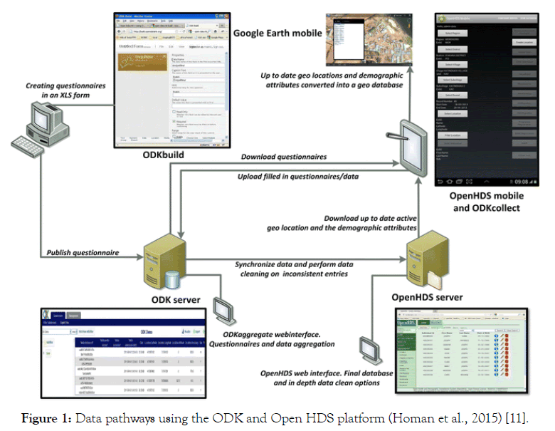
The data collection questionnaires were designed electronically using ODK which is free open source software. The Open Health and Demographic Surveillance (OpenHDS) data system is a software platform that is based on a centralized database and it was integrated with ODK Aggregate server to collect a continuous demographics, socio economic and individual health data on Rusinga Island HDSS since 2012 [11].
A malaria survey was conducted questionnaire that was also designed in ODK was used to capture data on the following parameters; body auxiliary temperature measured by means of a Braun™IRT 3020 ear thermometer, testing for presence of antigen malaria parasites using Rapid Diagnostic Test (RDT) kit, altitude, latitude, longitude, bed net usage and occupation.
The Keyhole Markup Language (KML) files were used to help in locating individual participants to speed up the interview process and to ensure accurate identification of the study participants during data collection from the selected households. A statistical analysis software known as STATA was sued to perform frequencies, univariate and multivariate logistic regressions to explain the relationship between malaria prevalence and risk factors influencing malaria.
Innovative Mobile Data Collection Technology
This study used a mobile handheld Tablet with GPS enabled receiver to collect geo-coordinate data for each household and mosquito breeding sites and data was submitted to a central webbased database server in real time as shown in Figure 1. Open Health and Demographic Surveillance Systems (openHDS) was systematically integrated with other systems due to efforts of the INDEPTH network (International Network of field sites with continuous Demographic Evaluation of Populations and Their Health in developing countries) to collect and manage demographic and health information data in real time. The systems are built around a core structure that is flexible enough to accommodate most longitudinal studies of populations. Such systems are important in putting together population-based research in areas where national or local authorities lack a proper registration system to monitor important demographic events [11].

Figure 1: Data pathways using the ODK and Open HDS platform (Homan et al., 2015) [11].
Sample Size
The target population for the study was made up of the people living in Rusinga Island which is located in Lake Victoria, western Kenya. As of 2015 the Island had a population of approximately, 7300 houses and 24,000 individuals. Rusinga Island is approximately 44 km2, which translates to a population density of approximately 546 persons per square kilometre.
A sample size of 2336 participants were obtained from a population of 24000 individuals by adopting the formula by Cochran (1977), who provided a formula which is appropriate with large populations to calculate a sample size. This formula was used to calculate the sample as shown below. A 95% confidence level and level of precision of 2% (0.02) P=2% are assumed for equation below:
 (1)
(1)
where,
e is the desired level of precision (i.e., the margin of error),
p is the (estimated) proportion of the population which has the attribute in question,
q is 1-p.
no=((2.9)2 (0.5) (0.5))/(0.03)2=2336 (2)
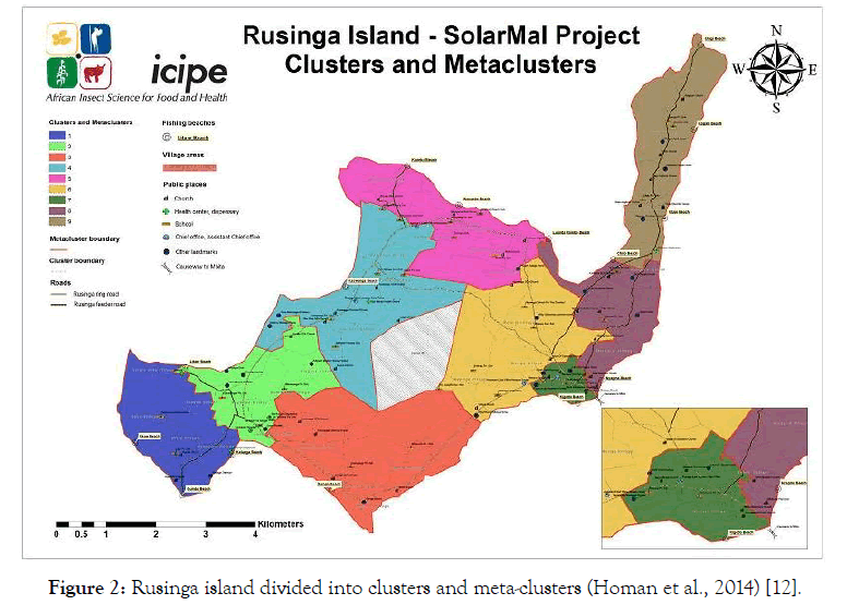
For administration, the study area was divided into in 9 Metaclusters and 81 Clusters (Figure 2).

Figure 2: Rusinga island divided into clusters and meta-clusters (Homan et al., 2014) [12].
For better understanding of the underlying demographic and social risk factors, the analysis was done on the key variables such as, occupation type of wall and type of roof of the house that were included in the conceptual framework for malaria infection. The individual participants were also categorized into four major age groups. The analysis of malaria was based on four various age groups, which included young children below 5 years (<5 years), children at school age (5-14 years), adults (15-49 years) and old persons (≥ 50 years) respectively. The frequency indicated that malaria prevalence was high among the under-5 years and children of age between 5-14 years in both surveys. There was an overall reduction of malaria prevalence in all the age categories during December 2015 survey as indicated in Table 1.
Table 1: Proportion of population screened for malaria based on age group, 2015.
| Age groups years |
Number sampled in August 2015 n (%) |
Number of malaria cases n (%) |
Number sampled in December 2015 n (%) |
Number of malaria cases n (%) |
|---|---|---|---|---|
| <5 yrs | 302 (12.5) | 53 (17.5) | 265 (12.64) | 45 (12.6) |
| 5-14 yrs | 720 (33.02) | 140 (19.4) | 700 (30.14) | 113 (30.1) |
| 15-49 yrs | 1123 (45.57) | 196 (17.5) | 966 (47.01) | 127 (47.0) |
| >49 yrs | 244 (8.92) | 31 (12.7) | 189 (10.21) | 21 (10.2) |
| Total | 2389 | 420 (17.6) | 2120 | 306 (14.4) |
The age groups 5-14 and 15-49 years old were the most affected and the study results futher indicated that malaria risk was also observed to be 1.12 times higher among individuals of age between 5-14 years [OR=1.12 (0.724, 1.723)] and 1.15, 1.12 times higher among individuals of age between 15-49 years [OR=1.15 (0.807, 1.642)] as shown in Table 2.
Table 2: Malaria prevalence and risk factors based on the two surveys.
| Variable | Categories | p value | OR | 95% CI for OR | |
|---|---|---|---|---|---|
| Lower | Upper | ||||
| Age group | <5 yrs | 0.771 | 1.10 | 0.581 | 2.082 |
| 5-14yrs | 0.618 | 1.12 | 0.724 | 1.723 | |
| 15-49 yrs | 0.444 | 1.15 | 0.807 | 1.642 | |
| Occupation | Fishing | 0.082 | 3.62 | 0.851 | 15.383 |
| Farming | 0.216 | 2.95 | 0.531 | 16.358 | |
| Outdoor occupations | 0.086 | 3.51 | 0.839 | 14.666 | |
| Clerical or indoor occupations | 0.270 | 2.39 | 0.509 | 11.192 | |
| Housewife | 0.152 | 3.08 | 0.661 | 14.324 | |
| Students and school children | 0.036 | 4.65 | 1.109 | 19.523 | |
| Children under five years old | 0.051 | 4.54 | 0.993 | 20.739 | |
| Jobless/Unemployed | 0.029 | 5.58 | 1.188 | 26.249 | |
| Retired | 0.844 | 1.21 | 0.188 | 7.752 | |
| Bed net use | No | 0.009 | 0.40 | 0.203 | 0.794 |
| Yes | 0.000 | 0.20 | 0.120 | 0.325 | |
The occupation risk factor of malaria infection indicated that malaria prevalence was 5.58 high among the jobless and unemployed individuals [OR=5.58 (1.188, 26.249)], the student and school children were at 4.65 times risk [OR 4.65 (1.109, 19.523)], children under five at 4.54 time risk [OR=4.54 (0.993, 20.739)] and closely followed by outdoor occupation at 3.51 times risk [OR=3.51 (0.839, 14.666)]. The individuals who were sleeping under bed-net always were at low risk of malaria [OR=0.20 (0.120, 0.325)] as compared to those who did not sleeping under bed-net [OR=0.40 (0.203, 0.794)] [12,13].
Population Of Various Types Of Mosquito Breeding Sites
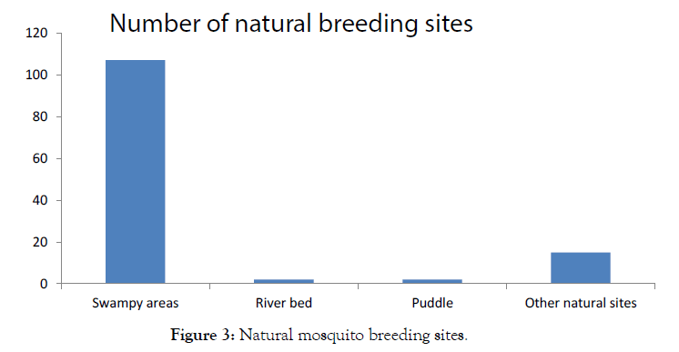
The breeding sites were also categorized into natural breeding sites (n=135) and artificial breeding sites (n=118) whereby each category had different types of water bodies as shown in Figure 3. The existing natural breeding sites were due to topographical nature of the area making it possible for the flooding water to settle in swampy areas around Lake Victoria during the rainy season, while those artificial were as a result of farming, sand digging activities and hippopotamus foot prints on shores of Lake Victoria.

Figure 3: Natural mosquito breeding sites.
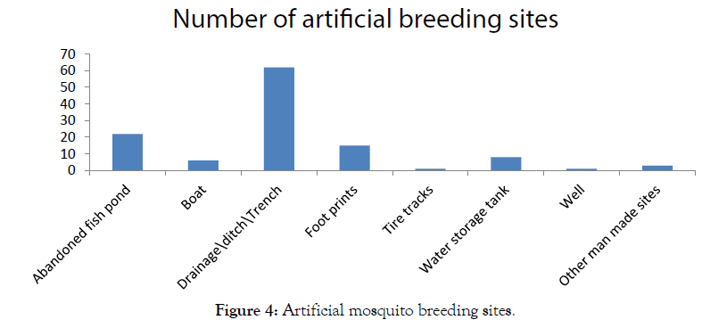
The potential anopheles mosquito breeding sites in the study area consisted of swampy areas (n=107), drainage\ditch\trenches (n=62), abandoned fish ponds (n=22), hippopotomus foot prints (n=15) and water storage tank (n=8) as shown in Figure 4. The most highest population of mosquito species that were found were Culex mosquito followed by Anopheline gambiae and Anopheline funestus, respectively.

Figure 4: Artificial mosquito breeding sites.
Physical And Environmental Risk Factors.
Further analysis showed that poor house structure was a significant risk factor for malaria in the study area. The largest population were living in houses that were built of wood and mud recording malaria prevalence of 18.8%, open eaves were at a prevalence of 17.8% as compared to compared to individuals of similar socioeconomic status but lived in better house structures as shown in Table 3. The second largest group individuals were living in houses made of brick and or block, which had a risk of 12.7% as shown Table 4.
Table 3: Summary of wall structure and malaria positive cases.
| Variable | Categories | Pop (% positive) | p value | OR | 95% CI for OR | |
|---|---|---|---|---|---|---|
| Lower | Upper | |||||
| Wall structure | Wood and mud | 1,470 (18.8) | 0.935 | 1.0 | 0.391 | 2.370 |
| Brick and or block | 451 (12.7) | 0.307 | 0.61 | 0.241 | 1.562 | |
| Mud and cement | 225 (17.3) | 0.782 | 0.87 | 0.337 | 0.272 | |
| Iron sheet | 191 (21.5) | 0.790 | 1.13 | 0.438 | 2.961 | |
| Open eaves | Yes | 2,174 (17.8) | 0.823 | 0.90 | 0.368 | 2.214 |
| No | 184 (14.7) | 0.505 | 0.72 | 0.268 | 1.909 | |
Table 4: Number of breeding sites and malaria case by geographical location.
| Variable | Categories | Number of breeding sites n (%) | Pop (% positive) | p value | OR | 95% CI for OR | |
|---|---|---|---|---|---|---|---|
| Lower | Upper | ||||||
| Altitude range | <1200m | 301 (99.7) | 418 (16.27) | 0.035 | 2.09 | 1.053 | 4.167 |
| ≥ 1200m | 1 (0.3) | 56 (8.5) | 0.035 | 0.19 | 0.240 | 0.950 | |
Classification Of Geographical Location Of Malaria Prevalence And Breeding Sites
The altitude were grouped into three major classes; less than or equal to1000 m, between greater than or equal to 1200 m. Analysis showed that out of 302 mosquito breeding sites, 94.67% of the breeding sites as well malaria prevalence of 17.9% were located on the lowland areas (where, altitude ≥ 1200 m), which was the same altitude range where the largest poulation (96%) of people were living. Malaria also recorded high malaria prevalene of 17.9% [OR=2.25 (0.686, 7.415)] among indiviudals who were living near areas that were concentrated with mosquito breeding sites. This was a clear indicator of a risk that individuals were more exposed to malaria infection in both seasons due to the promixity to the mosquito breeding sites as summarized in Table 4.
The malaria risk factors included demographic, social, and geographical risk factors on malaria prevalence. The study findings indicated that geographical location and socio-economic status of households were very important risk factors for malaria prevalence. Study findings revealed that individuals living in houses built of wood and mud, open eaves were at a higher risk compared to individuals from houses without open eaves. This was because houses with poor quality with holes on the walls and open eaves on the walls could allow mosquito entry into the house in search of blood meal from human beings. Further analysis also revealed that malaria prevalence was high among the four occupations namely; students and school children jobless, children under five years old and outdoor occupations respectively. The reason could have been due to their socio-economic status and daily outdoor activities especially late in the evening. The individuals were likely to be exposed as per the nature of activities for example school going children and persons involved in outdoor activities are likely to stay late when mosquito can actively bite. The high prevalence of malaria among younger age groups may have been due to the low immunity. The findings also showed that malaia prevalence was also high among individuals living in close to the breeding. Previous studies have also revealed that workers are at higher risk of malaria due to their outdoor sleeping, frequent movement and inadequate treatment.
There was a significant reduction of malaria prevalence between two time points. The reduction could have been due to high coverage and use of a combination of mosquito control measures such as; solar powered mosquito trapping system installed by Solarmal project and provision of malaria treament drug to individuals who were testedto be malaria positive.. Both surveys indicated that the most affected individuals were school going children with the highest precentage prevalence remaining above the overal in both seasons. This study has clearly shown that rural community livelihood activities are important factors to be considred in malaria transmission and control measure. These results supported other studies which showed that school children have the habbit of staying late in the evening hours and this could expose them to malaria risk. Malaria prevalence was still high among individuals who were living in houses built of wood and mud, iron sheet houses, open eaves and residential houses that were closer to the mosquito breeding sites. House improvement is one of the strategies that can help to reduce malaria infection risk.
The study has shown that mobile technology can be used to collect for early warning systems for that can provide useful information for prevention and control of diseases or epidemics. The new technologies have the potential to bring about a fundamental shift in targeted response or intervention in areas with high epidemics. A mechanism of early warning systems enables us to determine the optimum time for action and also helps in decision making when warning have been issued. This provides an opportunity for the deployment of mobile technology that can be used for real time data collection leading to a cost effective implementation of an early warning system for curbing malaria and subsequent reduction of deaths that are related to malaria.
Citation: Onyango OK, Ochieng OJ and Solomon O (2019) Deployment and Use of Mobile Technology to Control Malaria. J Inf Technol Softw Eng 9:255.Doi: 10.35248/2165-7866.19.9.255
Received: 15-Apr-2019 Accepted: 03-May-2019 Published: 10-May-2019 , DOI: 10.35248/2165-7866.19.9.255
Copyright: © 2019 Onyango OK , et al. This is an open-access article distributed under the terms of the Creative Commons Attribution License, which permits unrestricted use, distribution, and reproduction in any medium, provided the original author and source are credited.