Journal of Oceanography and Marine Research
Open Access
ISSN: 2572-3103
+44 1300 500008
ISSN: 2572-3103
+44 1300 500008
Research Article - (2023)Volume 11, Issue 4
Sagar Island has occurred in many places from 2000 to 2016. There is a clear evidence of decreasing land area of inward shifting of shore line. The changes occurred by erosion due to sea level rise but some places deposition occurred by river and wave. Due to continuous sea level rise and low height of Sagar Island, sea level has been entered toward land. Average height along the coast is less than 2 feet and average height middle position of the island is 15 feet but some places height less than 4 feet and some places height more than 20 feet. We measure height of the some places and based on this height and Google earth image we draw contour line on the Sagar Island.
Erosion; Mangrove forests; Ganges-Brahmaputra delta; Sagar Island
Sagar Island is an island in the Ganges delta, lying on the continental shelf of Bay of Bengal about 100 km (54 nautical miles) south of Kolkata. This island forms the Sagar CD block in Kakdwip subdivision of south 24 Parganas district in the Indian State West Bengal. The island is large with an area of 224.3 km2, lying between 21°36’ to 21°56’ north latitude and 88°2’ to 88°11’ east latitude. It has 43 villages and a population of over 160,000. The largest village is also named "Ganga Sagar" or "Gangasagar". Although Sagar island is a part of Sundarban administration, it does not have any tiger habitation or mangrove forests or small river tributaries as is characteristic of the overall Sundarban delta [1].
This island, also known as Gangasagar or Sagardwip, is a place of Hindu pilgrimage. Every year on the day of Makar Sankranti, hundreds of thousands of Hindus gather to take a holy dip at the confluence of river Ganges and Bay of Bengal and offer prayers (puja) in the Kapil Muni temple. Sagar Island, westernmost island of the Ganges-Brahmaputra delta, West Bengal state, northeaster India. It lies at the mouth of the Hugli (Hooghly) river, an arm of which separates it from the mainland to the east. Situated at a point where the Ganges (Ganga) river once met the Bay of Bengal, the island is held to be particularly sacred and is a noted Hindu pilgrimage center. A three-day bathing festival and large fair are held annually. The island is subject to severe cyclones. It has a lighthouse on the south-western shore to guide traffic up the Hugli.
Recently huge population pressure due to tourist visit costal area loses its sustainability [2].
The GBD, of which Sundarban structures the beach front part, is lined by high countries on every one of the three 48 sides excepting a 125 expansive entry that connects the district to its northern provenance. This is known as the Rajmahal- Garo Hole (RGG), a worn-out seat of the Indian craton between the Rajmahal and the Garo slopes. Other than the RGG, the northern and eastern limits of the delta are characterized by the crystallines of the Meghalaya level, the Rajmahal slopes and the Chhotanagpur level, which were all pieces of the Gondwanaland up to the Jurassic [3]. The eastern limit of the delta is depicted by the Neogene sedimentaries of Chittagong-Tripura Crease Belt (CTFB). The subaerial and underwater pieces of the GBD should be visible as necessary pieces of the Bengal. Depositional framework that stretches from south of the Himalaya to the distal edge of the Inlet of Bengal. Its deltaic parts incorporate a higher-slope fan delta in the north, described by upward and horizontally relocating sand-overwhelmed braidbelts; a lower inclination fluvio-flowing segment in the southeast which is incorporating into the ocean with nearly stable channels; and a fluvially deserted flowing area in the southwest that is accumulating in an upward direction yet in addition declining irreversibly in specific segments.
The southwestern part, alongside southern shore of the delta between the Hugli and the Baleswar estuaries, is essentially contributed by the distributaries of the Ganga framework dynamic or disseminated. Its 200 km littoral stretch is around 47% of the GBD shore and harbors the biggest adjacent mangrove timberlands of the world the Sundarban. This article first surveys the development of the Sundarban locale as a piece of the Bengal bowl and the GBD. It then, at that point, examines the fundamental regular and anthropogenic forcings chipping away at the region and how the area is answering them [4].
Objectives
• Area measurement of erosion and deposition along the coast.
• Forecasting of land which is effects by sea level rise and their
mapping.
Study area
The study area is Sagar Island lying on the mouth of Hoogli river in northern part of south Pargana. The study area extends 21°36’ to 21°56’N and 88°2’ to 88°11’E. The Sagar Island lying within Hoogli river (west), Muriganga river (east) and Bay of Bengal (Figures 1 and 2) [5].
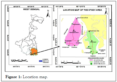
Figure 1: Location map.
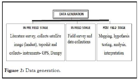
Figure 2: Data generation.
Field investigation and sampling
We measure height by GPS, dumpy level and from Google earth of different part of the study area randomly. Measure height from sea level of Sagar Island. We collects height along the coast line by dumpy level and GPS. Other area height collects by Google earth [6].
Analysis and interpretation
Mainly used RS and GIS for mapping, analysis and interpretation. RS and GIS used for area measurement of erosion and deposition along the coast and forecasting of land which is effects by sea level rise and their mapping [7].
Changes of shoreline
Clear changes in the shoreline of Sagar island has occurred in many places from 2000 to 2016. There is a clear evidence of decreasing land area of inward shifting of shore line (Table 1). The changes occurred by erosion due to sea level rise but some places deposition occurred by river and wave [8].
| Sl. no | Village name | Location code | Erosion (sq.m) | Deposition (sq.m) | Average length of erosion toward land in erosional place (m) | Average length of deposition toward sea in depositionl place (m) |
|---|---|---|---|---|---|---|
| 1 | Kastala | 335240 | 128218.07 | 845495.12 | 50 | 470 |
| 2 | Shapkhali | 335241 | 180361.6 | 65127.15 | 65 | 55 |
| 3 | Bamankhali | 335248 | 91484.62 | 80 | ||
| 4 | Mandirtala | 335249 | 159730.51 | 90 | ||
| 5 | Phuldubi | 335250 | 363782.79 | 130 | ||
| 6 | Krishnanagar | 335265 | 622362.81 | 260 | ||
| 7 | Naraharipur | 335266 | 1041972.75 | 290 | ||
| 8 | Radhakrishnapur | 335268 | 726313.63 | 250 | ||
| 9 | Chandipur | 335269 | 1281726.25 | 445 | ||
| 10 | Manishhamari | 335271 | 553848.7 | 25018.98 | 380 | 85 |
| 11 | Beguakhali | 335272 | 676631.54 | 270 | ||
| 12 | Gobindapur | 335273 | 505679.68 | 21415.21 | 250 NW | 45 SE |
| 13 | Gangasagar | 335274 | 539689.27 | 210 | ||
| 14 | Dhablat | 335281 | 1070431.19 | 270 | ||
| 15 | Bisalakshmipur | 335280 | 906428.56 | 460 | ||
| 16 | Chemaguri | 335278 | 1180107.25 | 230 | ||
| 17 | Bankimnagar | 335259 | 608447.75 | 205 | ||
| 18 | Sumatinagar | 335258 | 240859.14 | 110 | ||
| 19 | Mrityunjoynagar | 335257 | 293067.09 | 95 | ||
| 20 | Kaylapara | 335255 | 20418.94 | 9111.87 | 50 S | 20 N |
| 21 | Debimathurapur | 335254 | 124266.51 | 118744.05 | 150 N | 85 S |
| 22 | Gobindapur | 335253 | 434835.58 | 275 | ||
| 23 | Ramkrishnapur | 335245 | 160061.11 | 210 | ||
| 24 | Sikarpur | 335244 | 127328.24 | 75 | ||
| 25 | Muriganga | 335243 | 262556.35 | 70 | ||
| 26 | Kachubaria | 335242 | 60705.26 | 60 |
Note: N-North ward, S-South ward, NW-North West ward, SE-South East ward
Table 1: Changing configuration of the shoreline of the study area.
The total changes of shoreline reveals 12361315.2 sq.m loss of land. Most erosion occur south and west ward of the Sagar Island and deposition occurred only six places of the island 1084912 sq.m. Some village erosion and sea level rise is more than other due to low height and human activity so, sea level easily entered into land. By the use of Landstat image of 2000 and 2016 we are found that net erosion of Sagar Island (Figure 3) [9].
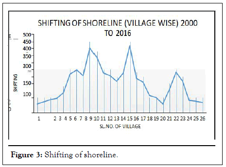
Figure 3: Shifting of shoreline.
Some area sea level entered close to 500 meter and some area close to 50 meter due to slope variation and wave variation along the shoreline. Toward south and west wave height is more (0.30 meter) so sea level enter toward land erosion is high than north and east ward due to wave height is low compared to south and west (0.20 meter). Toward south and west wave height is high due to this zone is edge of the ocean and south west monsoon wind (Figure 4) [10].
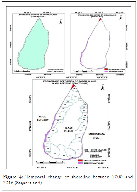
Figure 4: Temporal change of shoreline between 2000 and 2016 (Sagar island).
Prediction of shore line and land below sea level (Sagar Island)
Due to continuous sea level rise and low height of Sagar Island, sea level has been entered toward land. Average height along the coast is less than 2 feet and average height middle position of the island is 15 feet but some places height less than 4 feet and some places height more than 20 feet. We measure height of the some places and based on this height and Google earth image we draw contour line on the Sagar Island [11].
According to IPCC sea level rise globally by global warming during 20th century 1.8 millimeter per year but from 1993 to 2010, that rate increased to 3.1 millimeter per year. Scientist predicted that sea level can be rise 50 to 98 cm in 21th century. But local sea level rise as much as 25 millimeter per has been recorded in section of Ganga-Brahmputra delta. This high rate sea level rise in this delta due to natural sinking and setting of land (subsidence) and global warming. So, sea level can be rise close to 8 feet or 2.50 meter in 21th century. Due to this rate of sea level rise sea water will be enter in land and some places will be goes below sea level. About 81 sq.km area or 36% area height will be below sea level or goes below sea level. Due to sea level rise, most effect in the south and east ward side of the island due to low height compared to north and west ward (Figure 5).
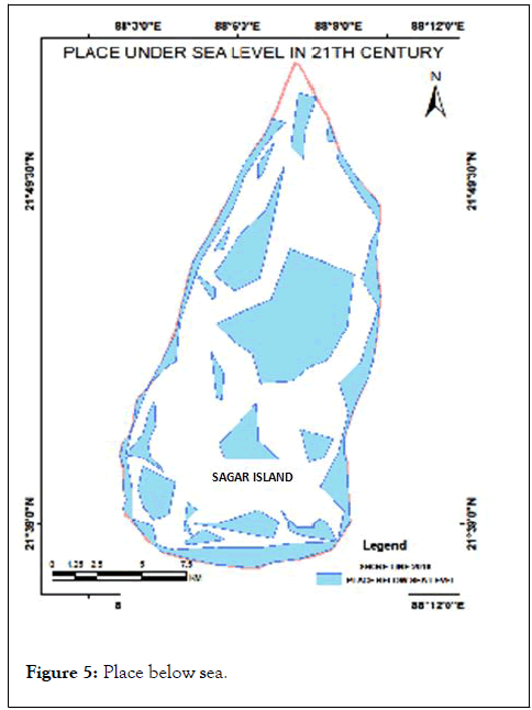
Figure 5: Place below sea.
Drainage network of Sagar Island
A network of creek and cannel are interconnected and intersected the island. Every creek are connected with ocean in south ward and north, east west ward connected with river but every creek effects by tide in ocean. During high tide sea water enter into the creek, flow sediment and water toward land and during low tide sediment and water flow toward sea. Creek network of Sagar Island has divided the whole island into 16 small Island. But due to sea level rise infilling of creek and overtopping of water during high tide so, flooded condition developed. Tidal creek width, depth and position has been changed due to sea level rise and human activity such as bund formation, agriculture practice, aquaculture practice and solid waste deposition etc. so, natural condition of Sagar Island has been destroyed and vulnerability increased (Figure 6) [12].
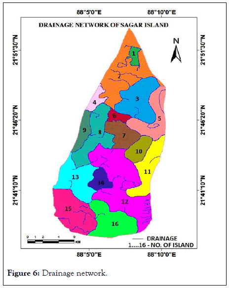
Figure 6: Drainage network.
Bar formation along the coast of south west Sundarban
By comparative analysis of Landsat image of 2000s and 2016s we found that three new bar has been formed along the coast. We are used near infrared band of satellite image because this band best help to find out the topographic feature along the coast. This bar form by wave and current deposition due to reduced slope by the sea level rise (Figure 7) [13].
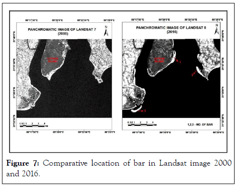
Figure 7: Comparative location of bar in Landsat image 2000 and 2016.
Sagar Island is an inevitable part of Bengal basin. Physically and economically it has an importance. Actively and passively more than 150,000 people are dependent on the land of this island. But due to some unscientific activities, gradually it moves into list of endangered islands. This should be stopped, otherwise Sagar Island will be remove from the map of West Bengal. Sagar Island is characterized by the changes in the estuarine hydrodynamics, causing continuous erosion and deposition and by anthropogenic activities. The areal extent of coastal vegetation and agricultural lands has declined. The major coastal vegetation, including mangroves and estuary is under human threat and immediate steps are needed. The net rate of erosion from 1967 to 1999 is estimated as 0.74 km further, natural and anthropogenic activities are causing severe changes to the island, especially in the northern, south-eastern and south-western faces.
Citation: Khan R (2023) Evolution of Shoreline in the Fringe Area of Sagar Island in Sundarban, West Bengal. J Oceanogr Mar Res. 11: 283.
Received: 09-Aug-2019, Manuscript No. OCN-23-1073; Editor assigned: 14-Aug-2019, Pre QC No. OCN-23-1073 (PQ); Reviewed: 28-Aug-2019, QC No. OCN-23-1073; Revised: 01-Nov-2023, Manuscript No. OCN-23-1073 (R); Published: 29-Nov-2023 , DOI: 10.35248/2572-3103.23.11.283
Copyright: © 2023 Khan R. This is an open-access article distributed under the terms of the Creative Commons Attribution License, which permits unrestricted use, distribution and reproduction in any medium, provided the original author and source are credited.