Journal of Geology & Geophysics
Open Access
ISSN: 2381-8719
ISSN: 2381-8719
Short Communication - (2021)Volume 10, Issue 1
Shahrebabak in Kerman province, in southern central Iran, is located along Tectono-Volcanic strip of Urumieh- Dokhtar. This strip is mainly composed of volcanic and pyroclastic rocks of Tertiary and Upper Cretaceous Ophiolite Melanges have been observed along major fractures on its south western parts. Based on geophysical studies, the Northeastern part of the area is most likely to contain metal elements’ anomalies and the southern part of the region is also among promising areas. Landsat ETM remote sensing survey showed that the Northeastern part of the region show potential mineralization in band ratio techniques, classification methods and also application of PCA and as a result is more suitable for regional exploration. There is a logical connection between fractures in the area and alteration zones which imply the role of faults and magnetic lineaments in the mineralization in the area.
Techno-volcanic; Pyroclastic; Tertiary; Upper Cretaceous ophiolite; ETM remote sensing; Magnetic mineralization
The magnetic geometry airborne in regional exploration of metal elements, especially ironstone is one of the most useful and important methods [1] beside the exploratory magnetic geometry aerial information, one could use data such as geology, regional geochemistry and telemetry. Shahrbabak zone is located in the South-East of Kerman and in the geographical coordinates 00 and 55 to 80 and 55 to 80 eastern longitude and 80 northern latitudes.
Now a days remote sensing is used in many different industries, it is used to distinguish the borders between countries [2] or use in progress in identifying and characterizing Biocrusts [3]. On the other hand, morphology of rocks are investigated and modeled to reach characterization of minerals [4]. Texture and chemistry of pyrite at Chah Zard epithermal gold–silver deposit in Iran was investigated [5]. The general morphology trend of the area is NWSE, and includes the Nar mountain areas, Mozahem Mountain and Pa-Ghaleh in the North-East and Shahrebabak pampa in the South-West. Mozahem Mountain with 3473 m height is the highest point of elevation in that area. Drainage system in the high points is generally radial and controlled by the northern young volcano [6]. In this survey, for identifying capable metal mineralization regions in Shahrebabak zone, in addition to digitize geological map data and provide supplementary data by overlaying the information provided above, promising areas are determined. The Shahrebabak zone is located in southern central Iran and in Tectono-Volcanic strip of Urumieh-Dokhtar, and is mainly composed of volcanic and pyroclastic stones from Tertiary and the oldest stones of the area date back to Upper Cretaceous. In this area, Tertiary Magmatism is made of three stages [7]. Volcanic Sequence of Paleogene includes Basaltic andesite, Latite, Tfryts riched with Analism and some Nepheline Phonolite that are formed in a continuous strip with Northwest-Southeast trend.
In this volcanic complex, magma composition has changed from Basaltic Andesitic calk-alkaline Eocene to Oligocene Shoshonitic systems [8]. After these stones are formed, Lateritic weathering and regional upheaval in some areas caused local deposition of underlying red Clastic system. In Miocene, volcanic activity began with Latite-andesitic combination to Dacite and created great Stratovolcanoes in the area, and at this time the composition of magma was changed from Shoshonitic to normal Calk-alkaline [9]. Ore deposit in Sarcheshmeh and Miduk copper are associated with this magmatic phase. Sequence of Trysr between the Miocene and Pliocene has been affected deformation and upheaval. Sub Miocene– Quaternary volcanism is identified by lavas and dikes of olivine basalt and a little Lecithins and Nflynyts which are enriched with Phlogopite [10]. Olivine basalts in the form of lavas with relatively limited expansion cover Quaternary terraces in some places, these Basalts contain Microphone-Crystals of Olivine and Clinopyroxene which are spread over a background of microcrystals of plagioclase that are enriched by Potassium Sanidine, Titano-magnetite, and some glass. Apart from Olivine Basalts, dilatory Miocene volcanism in the region includes rare melafuidits. These stones are in the form of fine-grained porphyry lava that includes Phlogopite and Olivine macro-crystals over a background of Clinopyroxene, Nepheline, Leucite or Kalsylyt, Titano-magnetite with minor amounts of glass. These stones are located at Kohgary in the northern slopes of the Mozahem volcanic mountain. In terms of metallurgy the area of Shahrebabak is a part of Central Iran copper belt. Regional and detailed exploration studies in Kerman have shown that there are many similarities between the indexes and deposits of this region in terms of mineralization and the mineralization has taken innately in hydrothermal phases and different temperatures (Geological Organization and Mineral Exploration Agency of Iran) regarding of the type of covering stone and mineral emplacement, two types of porphyry and veins mineralization could be observed. Porphyry mineralization has been within or around the semi-deep intrusive bodies or near the volcano’s crater and volcanic domes. Sarcheshmeh, Miduk, Darhezar and Nochovan deposits are among this type. Veins mineralization has been mainly formed in the series of volcanic Paleogene and they are less common within intrusive bodies. One of the characteristics of these deposits is presence of primary Chalcocite.
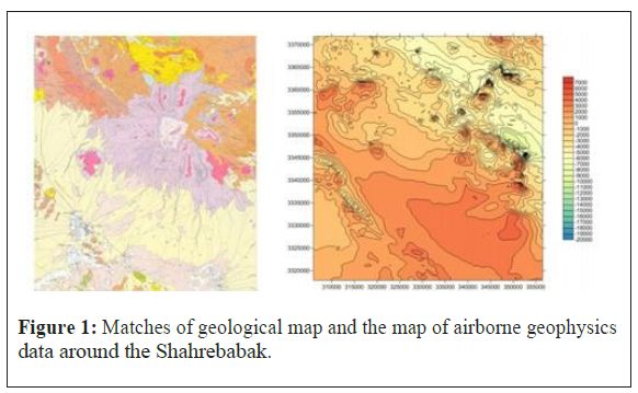
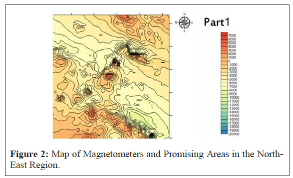
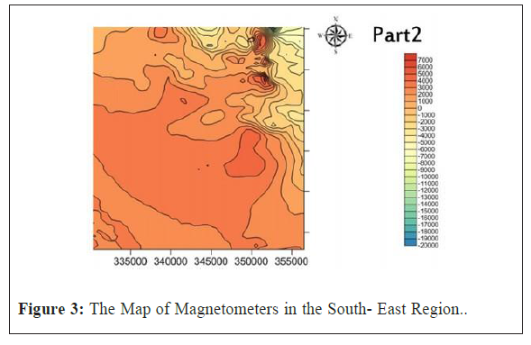
Geophysical surveys and Telemetry: Geophysical surveys include parameters of conductivity measurement, magnetic susceptibility, density and aggregations of radioactive elements such as Potassium, Thorium, and Uranium, and the interpretation of geophysical data has been done qualitatively and quantitatively. (Figure 1) illustrates the overlaying of geological map of Shahrebabak and the map of airborn geophysics data around the Shahrebabak. For more detailed studies of Shahrebabak’s sheet 1: 100000, this area was divided to 7 sections 1:25000 and each section was analyzed separately. In the center of the Northeastern region, small sections show extreme differences in the magnetic properties and can be one of the best types of anomalies. In this area (Figure 2) obtained anomalies around the igneous stones include Trachyandesite, Trachybasalt and minor pyroclastic stones (Figure 2). In most parts of the South-East region, the magnetic properties are high but in this area no particular anomaly has been seen (Figure 3). In the Eastern part of Southwestern section of the region, high levels are seen, in this area magnetic anomalies are located on sandstones, and according to the magnetic properties of sandstones, further studies should be carried out regarding its authenticity. Around the North-West of the region, indicator anomalies cannot see. In telemetry, by measuring the electromagnetic waves which come from sunlight reflection from an object and by observing it from a far distance without physical contact, valuable information about the type, composition, humidity, temperature, etc. could be obtained. By using this information and analyzing it, one could achieve useful results regarding mineral exploration (Karimpour, and Alami niya, 9838). In this survey, the data from ETM has been used to determine promising mineral areas of in the region, and it has been applied to find potential metallic minerals with a band ratio 1/3. One of the problems in ETM images is small numbers of band and low local separation ability, in which it may cause mineral alterations to be mistaken for other geological phenomena. In colored composition RGB: 4 / 3-5-5 / 7 is applied to the image, the white pixels represent areas with alterations and purple pixels represent vegetation. In the processing of satellite images of Shahrebabak zone, it revealed that the North-East region is a high potential area for exploration. In this area, in methods of ratio banding and PCA and applying the classification methods, existence of possible mineralization has been proved. Moreover, by applying different filters on the image and also for implementing the faults of the region on alteration zones, a logical relation between fractions and halo of alterations could be seen.

Figure 1. Matches of geological map and the map of airborne geophysics data around the Shahrebabak.

Figure 2. Map of Magnetometers and Promising Areas in the North-East Region.

Figure 3. The Map of Magnetometers in the South- East Region.
In the geophysical survey which was conducted by airborne magnetometers, in the Northeastern region, it’s most likely there's an anomaly due to the changes in the amounts of magnetic properties and existence of igneous stones. Telemetry introduces the Northeastern part of the region as a candidate for regional exploration. In this area, through methods of ratio banding and PCA and application of the classification methods, existence of possible mineralization has been proved. Moreover, applying different filters on the image and also implementing the faults of the region on alteration zones, it’s obvious that there is a logical relation between fractions and alteration halos. Considering the overlapping of these two independent methods in the Northeastern part of exploration region, this area could be introduced as probable anomaly no 1, with the highest chance of mineralization.
Citation: Hootan K (2021) Explore the Metal Elements of Shahrebabak Based on Geophysical Data and Remote Sensing. J Geol Geophys. 10:123.
Received: 09-Feb-2021 Accepted: 25-Feb-2021 Published: 04-Mar-2021 , DOI: 10.35248/2381-8719.21.10.493
Copyright: © 2021 Khodaparast H. This is an open-access article distributed under the terms of the Creative Commons Attribution License, which permits unrestricted use, distribution, and reproduction in any medium, provided the original author and source are credited.