Journal of Geology & Geophysics
Open Access
ISSN: 2381-8719
+44 1478 350008
ISSN: 2381-8719
+44 1478 350008
Research Article - (2021)Volume 10, Issue 7
Qarun-East Bahariya oil fields located in the Qarun Concessions in the proven and prolific Mubarak sub-basin and Gindi basins area, Western Desert, Egypt. The present work focuses on the structure interpretation and inversion style and its impact on the hydrocarbon entrapped oil and proceeds different traps in two basins. The Mubarak structure is a doubly plunging anticline some 50 km wide and 100 km long that trend 70°E and comprises a main northerly anticline with subsidiary subparallel folds to the south. The Gindi Basin is bounded from the north by Kattaniya highly inverted basin and from the south by Wadi El Rayan-Silla high. As to Abu Gharadig basin it is bounded from the north by Qattara ridge and from the south by Sitra platform. Both basins are separated by the Kattaniya platform. In this area oil fields producing ranging from small to large size hydrocarbon accumulation, the cretaceous reservoir deformed by series of NE-SW-trending left-stepped en echelon oblique folds, due to strike slip movement cut by ENE-WNW faults and N-S to NNW trending and NW normal faults. Inversion causes decreases the amount of overburden in the highly inverted area, which can adversely effect of the top seal and the maturation of source rocks within the underlying syn-extensional section. All geological elements (structure and stratigraphic) have been interpreted throughout the analysis of well logs and interpretation of the magnetic and recent 3D seismic data, to do Prospect generation, evaluation and to understand the characteristics of different types of the reservoir intervals, type of trap system, identifying sandstone channels and faults; as well as delineating the stratigraphic plays of good reservoirs. Synthetic seismograms have been constructed for all available wells to tie stratigraphic horizons with seismic data and to define the lateral Facies variation of the beds. Constructed many Isopach maps in the study area, to validate inversion and hydrocarbon accumulation in the time of migration. The isopach maps of Khoman and Apollonia showed thickness variation, with thinner in the highly inverted area (Mubarak inversion), but going to thick in the mild inverted area (Asala ridge) and the isopach map of Masajid showed there is no Jurassic section at the S-SE or thin section was deposited at N-NW trends of the study area, it is considering the best location for drilling in shallow targets and high risk of deep reservoir. In highly inverted areas could be produce traps which hydrocarbon charged from Khatatba source rock that caused fill to spill as Qarun field, but in case the trap formed within mild to moderate inversion and there enough top seal, some of traps partial fill that receive hydrocarbon charge from regional source rock as Yomna field. This paper presented re-evaluate ARC, ARD and Jurassic tight reservoirs, which already produce at SWQ field, starting to apply modern technical studies by supporting new seismic attributes such as Qemscan analysis how can to improve the reservoir properties (porosity and permeability). According to this re-evaluation of well data, gases, oil shoes, image interpretation and attributes analysis, there are many opportunities in these reservoirs, which have good potentiality and promising targets. The tectonic evolution and structure analysis of the study area shows great similarity to the deformation of the ‘tectonically style, which generate the oil traps, where several hydrocarbon fields have been discovered.
Gindi; Mubarak; Qarun; Wrench; Petroleum system
The study area is situated at about 200 km to the west-south-west of Cairo (Figure 1), which are located at Qarun Concessions, covering a surface area of about 14,900 km2 and delineated by latitudes 29°15′ to 30°00′ N and longitudes 29°10′ to 31°00′ E in Figure 1.
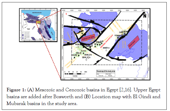
Figure 1: (A) Mesozoic and Cenozoic basins in Egypt [2,16]. Upper Egypt basins are added after Bosworth and (B) Location map with El Gindi and Mubarak basins in the study area.
Qarun and East Bahariya concessions are located in the proven and prolific Gindi and Mubarak sub-basin.
Positive inversion anticlines are considerable interest features of oil and gas explorationists, it has many effects on all aspects of petroleum systems: maturation, migration, trapping, and sealing, but negative inversion is less economic important. In some parts of study area, the Inversion causes decreases the amount of overburden and top seal rock. The work deals with utilizing applications of geophysical techniques to assist the subsurface structural setting as well as the tectonic evolution, and their impact on the prospectively in the study area.
Geological sitting
Structure: The North Western Desert of Egypt comprises a chain of NE-to ENE oriented rift-related basins. The rift-basins in northern Egypt are part of the greater Tethyan passive margin [1]. The regional tectonic stratigraphy, structural setting and tectonic evolution of many of these prolific sedimentary basins was identified through the deep drilling processes associated with oil and gas exploration, as well as the gravity, magnetic and seismic data analyses [2-8]. Sarhan and Collier, Alamein, Abu Gharadig, Qarun, and most other Western Desert inverted structures were formed by extension and associated subsidence in the Late Jurassic to Early Cretaceous, followed by shortening in the Late Cretaceous to Eocene. The Late Cretaceous inversion, or “Santonian event”, was by far the most significant compressional tectonics to affect the Western Desert during the Phanerozoic, but there were other compressional events. The Gindi Basin is bounded from the north by Kattaniya highly inverted basin and from the south by Wadi El Rayan-Silla high. As to Abu Gharadig basin, it is bounded from the north by Qattara ridge and from the south by Sitra platform. Both basins are separated by the Kattaniya platform, as well as other basins in the north Western Desert, are NE-SW, ENE-WSW trending Jurassic to Early Cretaceous Rift Basins (Figure 2).
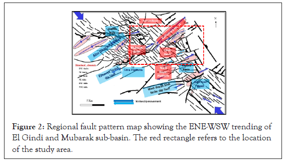
Figure 2: Regional fault pattern map showing the ENE-WSW trending of El Gindi and Mubarak sub-basin. The red rectangle refers to the location of the study area.
Stratigraphic: The stratigraphic column in East Bahariya Concession includes a sedimentary succession from Cretaceous to Miocene. The stratigraphic section consists of alternating depositional cycles of clastic and carbonates. The deep well drilled in the study area has revealed the presence of a subsurface stratigraphic column, which ranges in age from the Paleozoic to the Recent, about 12,000 feet. Sedimentation during the Late Cretaceous was interrupted during the Santonian by the development of inversion-related folds across northern Egypt [9]. The stratigraphy section in Gindi basin is characterized by a reduced sequence of Paleozoic rocks overlain by a limited continental Jurassic section including the Khatatba and Masajid formations [10]. The Jurassic section here is unconformably overlain by the Lower Cretaceous Kharita Member. Both Jurassic and Lower Cretaceous sediments are gradually wedged out southward into El-Gindi and Wadi El-Rayan provinces (Figure 3).
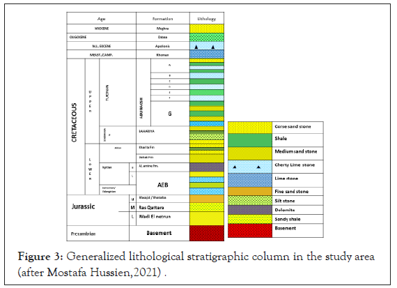
Figure 3: Generalized lithological stratigraphic column in the study area (after Mostafa Hussien,2021) .
In study area, the late cretaceous section (Abu Roash and Bahariya formation) is much thinner in the NE but seems thick to the SW. At the end of the Jurassic to earliest Cretaceous, the Jurassic deposited to the NW area at YOMNA-1 is thick than NE trend at Karama SW-12 which shows pinch out, but there is no Jurassic to the south and SE direction and basement relief is at Wadi Rayan is shallower than Mubarak sub-basin. Apollonia and Khoman which represent the good cap rocks are seemed thicker to the NE direction in the Gindi basin, which caused good maturation of ARF source rock, and Miocene sediments seem horizontal as showing in Figures 4 and 5
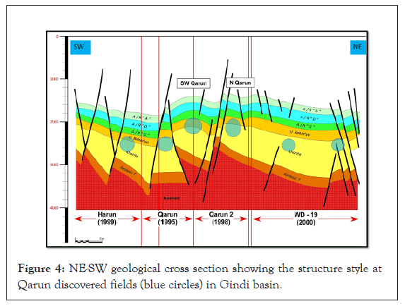
Figure 4: NE-SW geological cross section showing the structure style at Qarun discovered fields (blue circles) in Gindi basin.
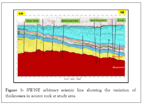
Figure 5: SW-NE arbitrary seismic line showing the variation of thicknesses in source rock at study area.
The stratigraphic correlation in the study area in Figure 6. Illustrate the sediments that recorded by deep drilling, it shows no Jurassic in the southern part of this area. The sedimentary basins in the north western desert were the scope of numerous investigations by regional geologists [11,12]. In the subsurface, El Gindi basin and the nearby Abu Gharadig basin to the northwest, have a similar sedimentary succession that extends from Paleozoic to Miocene and unconformably overlying the Precambrian crystalline basement [13]. El Gindi basin was stratigraphically subdivided into three litho-stratigraphic provinces from north to south; Kattaniya, El-Sagha and Wadi El-Rayan [11]. Similar dramatic thickening of the Apollonia Formation in front of inversion anticlines is clear in the Gindi basin that lies to the south of the Kattaniya inverted basin [14]. The Apollonia Formation reaches a maximum thickness equal to 2440 m in the Gindi basin. The depocenter of the syninversion Apollonia Formation lies to the southeast of the inverted Jurassic– Early Cretaceous basin, now forming the Kattaniya High. The Khoman Formation also shows abrupt thickening to the southeast of the inverted basin but its depocenter lies relatively closer to the inverted basin. This indicates that, during this later phase of basin inversion and growth anticline development, the deposition of the Khoman Member and Apollonia Formation occurred with continued migration of the depocenter away from the inverted basin, the correlation through the wells in the area based in well log data, Sonic, GR, Resistivity, and SP logs .The Hydrocarbon interval is nearly constant in the area,the deeper part of the formation is better in Facies than the upper and composed mainly of thick sand stone (Figure 6).
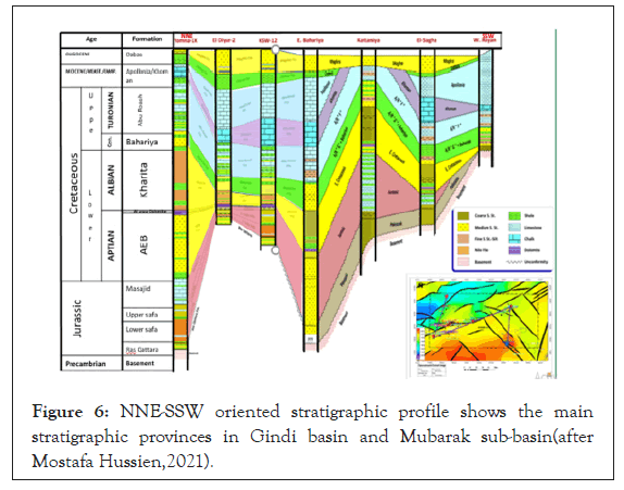
Figure 6: NNE-SSW oriented stratigraphic profile shows the main stratigraphic provinces in Gindi basin and Mubarak sub-basin(after Mostafa Hussien,2021).
Tectonic sitting: The Syrian Arc tectonic event has apparently developed a significant petroleum generation in most of the Western Desert basins, where many earlier troughs were inverted into large wrench-related breached anticlines and/or tectonic ridges. Seismic and borehole data indicate that the Jurassic and Lower Cretaceous sediments were deposited in rift-related basins, forming half graben geometry, bounded by a major normal fault on its down-dip direction. At the extreme up-dip direction the strata have gently-dipping to flat-topped areas referred to as platforms such as Figure 7.
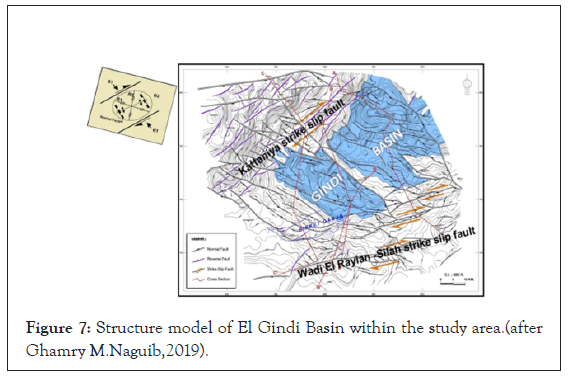
Figure 7: Structure model of El Gindi Basin within the study area.(after Ghamry M.Naguib,2019).
After the deposition of the cenomanian, turonian and lower senonian rocks, folding and reverse faulting (basin inversion) affected the upper cretaceous and older formations and controlled the deposition of younger Paleocene, Eocene and slightly Oligocene sediments in Gindi basin this phenomenon is clearly illustrated in Figure 8, where the sediment in the down thrown side of the Gindi fault, in Gindi basin area, has received charge from downdip Jurassic and/or Abu Roash F source-rocks and trapped in the down thrown side reservoir, which represent the best location to snatch hydrocarbon accumulation. From current study at Qarun area showed the NE-SW strike slip movement, compression and strain that did a good lateral seal which represent one of the important element of petroleum system what played the main role to accumulate the oil at Qarun fields (Figure 8).
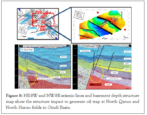
Figure 8: NE-SW and NW-SE seismic lines and basement depth structure map show the structure impact to generate oil trap at North Qarun and North Harun fields in Gindi Basin.
The applied methods in this study started with picking the seismic reflector corresponding to the topmost of Abu Roash D, ARG and Upper Bahariya members over the grid of seismic lines as well as the related faults (Figures 9,10,14), the reflector of these members showed clear and obvious over the whole area and, used all available data to re-evaluate the hydrocarbon potentiality of ARG and Upper-Bahariya main reservoirs includes: Well-logs, tying a synthetic model to a surface seismic data, interpreting the magnetic and recent high quality 3D seismic survey for prospect generation, evaluation and their relation to the hydrocarbon exploration, and using the suitable attributes analysis which may have a great support in delineating the geometry and trend of stratigraphic features and facies change to understand the characteristics the reservoir formations.
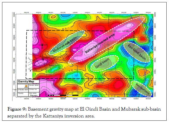
Figure 9: Basement gravity map at El Gindi Basin and Mubarak sub-basin separated by the Kattaniya inversion area.
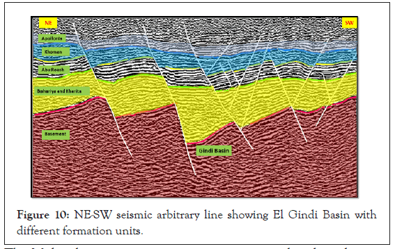
Figure 10: NE-SW seismic arbitrary line showing El Gindi Basin with different formation units.
The correlation between the obtained regional anomaly trends of both the gravity and magnetic data in the study area (using the poly nominal least square fitting and low-pass filter) showed the regional trends in the northeast direction and decrease to the northwest trend. The structural trend analyses of the shallow and deeper structural elements show the major sets of the trends in study area is NE-SW.
Seismic re-interpretation and different types of attribute analysis, structure and stratigraphy on the mature filed for explore the possible reservoirs to increase the production in this area. There is more attic oil in these fields; it recommended drilling more well for increase the productivity from shallow targets (ARC and ARD reservoirs) by using this different attributes and good closures from the structure contour maps. In the highly inverted area with thinner Khoman and Apollonia cap rocks even these pull a parts inside basins with thick cap rocks, its best location to drill more well due to these areas from analysis all drilled wells has high potentiality and low risk. Observed dry holes in all areas of highly structure and have not Apollonia and Khoman cap rocks. Apollonia, Khoman and Jurassic isopach maps reflect that, in the SE and NW corners of the study area are low risk to drill shallow targets but it seems risky to drill Jurassic targets, also showed there is no deep Jurassic reservoirs in the south of the study area, due the hydrocarbon potentiality from Jurassic are almost completely non-existent in this area, and these were confirmed by the drilled wells, so it recommended did no drill any Jurassic targets in this area. Observed from regional structure analysis the strike slip movement in this study area played the main role to construct lateral seal and good juxtaposition to generate trap and oil accumulation. Regarding the depleted reservoirs in this area, it recommended in mature field to acquire 4D seismic data to know the update of oil water contact. Recent geochemical work along with detailed mapping of newly acquired 3D seismic is greatly helping the delineation of the two potential source rocks and helping to formulate a clearer picture of hydrocarbon expulsion and migration within the Gindi and Mubarak basins. The results of this work may be applicable to the hydrocarbon potential of other basins. Oil correlation suggested that in this area there are two types of oil, marine oil generated from ARF source rock and terrestrial oil generated from Kharita shale source rock in the southern part of the study area. In the north and western part of this area the main source rock ARF and Khatatba shale which generated oil from terrestrial organic matter. There was more than one scenario for petro physical evaluation in our example at Yomna field which depend on three different values of porosity cut-off (6,7 and 8%), subsequently, three options are provided in volume calculations through the Net pay maps, when we used the same SW, RF and Bo through the same area.
Gravity and magnetic interpretation: The integration between aeromagnetic and gravity data interpretation is commonly used to delineate the regional subsurface structural framework, tectonic setting of the basement complex, and the overlying sedimentary cover thickness estimation. The potential field data (Boggier gravity and total intensity aeromagnetic maps) which carried out in the study area had been analyzed to extract information about the regional subsurface structural and tectonic framework of the buried basement rocks, as well as locating promising sites that probably favoring for the hydrocarbon accumulations. The depth of basement has been calculated from the 3D magnetic modeling depth ranging from 5 to 7 km where the Gindi basin has greater basement depth which is indirectly related to the thickness of sedimentary cover. The thickness of sedimentary rocks is increasing at the northern and southern part of the study area. The gravity map of the study area in Figure 9 showed the deepest locations of basement at the depocenter of Gindi and Mubarak basins (below dashed white ellipsoid shape) which matched with the seismic interpretation and Isopach map.
Seismic interpretation
The 3D seismic data (pre-stack depth migration) used to achieve the goals of this study. The available 3D seismic data represented in and used mainly for structural interpretation of the study area. The interpreted seismic line of different horizons and faults at Gindi basin showed in Figure 10.
The Mubarak structure is a major inversion anticline lying between the Abu Gharadig and the Kattaniya highly inverted area that separate between the Gindi basin to the east and the western basins to the west [15]. This basin represents an examples of good lateral seal, is when the basement is located juxtaposed against the sandstone reservoir in the down thrown side of the fault, therefore the promising area that has the good hydrocarbon potentiality it seems in SS direction at Asala block (Figure 11). The depth structure contour map of Basement relief based on 3D seismic data and well data at the study area in Figure 12 showed two main fault trends NE-SW, NW-SE and the NE-SW trending faults form the dominant fault trend. The structural configuration of the Basement rocks is structurally high area in the south parts from the study area. Recording depth values from 7450 ft. to 8250 ft. and also we have structurally low area along the central part in the study area made by the NE-SW fault trends recording depth values from 9500 ft. to 11200 ft. The faults are normal and trending in a NE-SW direction and throwing to the north forming half-graben structure. The major faults trends NE-SW direction in the study area down throwing in the north direction. The Precambrian tectonic trends in the Basement are of NE-SW trends that are a result of the Hercynian (Precambrian) Orogeny NE-SW the trending faults is inherited in the basement rocks of Gebel EL-Oweinat micro craton and extends through northern Egypt [16].
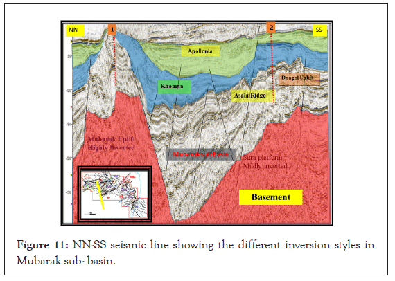
Figure 11: NN-SS seismic line showing the different inversion styles in Mubarak sub- basin.
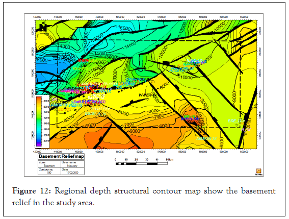
Figure 12: Regional depth structural contour map show the basement relief in the study area.
Seismic attributes
Seismic attributes are very useful in the characterization of fault and fracture in 3D seismic data volumes. The spectral decomposition attribute was used area in the study to delineating discontinuities, also can be used for channel development when channel appear as sand bodies in shale, in hydrocarbon indicator it is a classical attribute for hydrocarbon sand detection, from the Seismic attribute analysis showing ARG channel sand stone in EL-Gindi basin area in Figure 13, from this attributes analysis seemed the strike slip movement effected on the channel geometry at the kink area below the red color circles, which caused a good lateral seal and oil reservation to the north of these red circles in the zone of strike slip movement, which confirmed by the oil producing drilled wells in the north of these locations and dry hole to the south of it
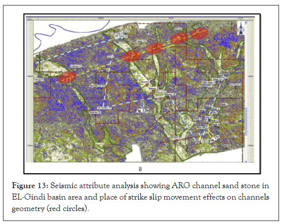
Figure 13: Seismic attribute analysis showing ARG channel sand stone in EL-Gindi basin area and place of strike slip movement effects on channels geometry (red circles).
Impact of inversion style on the hydrocarbon potentiality and evolution
The study area is related to the unstable shelf which covers the northern belt of Egypt, and is characterized by: Thick stratigraphic succession that ranges, in age, from Cambrian to Holocene time, varying in lithology, with thickness reaches 7 to 14 km in some subsurface basins (e.g. Abu Gharadig basin and Gindi basin), the main reservoirs in our study area (e.g. A/R G channel sandstone, the Bahariya and Kharita sand stone).
The structure of Gindi basin could be interpreted as an inverted half-graben, with the southerly dipping north-bounding fault acting as the major inverted extensional fault, to the southeast. North-dipping antithetic faults are also inverted. Depth structure map at Qarun area illustrate the strike slip movement caused pull a prat structure which consider the good chance to build traps and hydrocarbon accumulation, in addition to the NE to ENE and NW-oriented dip-slip faults, the most striking structural feature is a series of large NE-SW oriented right lateral strike-slip faults forming left-stepped an-echelon fault belts. They are easily discriminated and traced on the structure contour for the top of the late cretaceous (ARD) showing the structural setting and the promising area to get new opportunity in ARD reservoir at Qarun, ARD in Gindi basin display an NE-SW late cretaceous anticline plunging toward the NE-SW reverse faults (Figure 14).
Figure 14: ARD depth structure map at Qarun field showing strike slip movement (white arrows) accompanied with an-echelon folds.
The Mubarak structure is a doubly plunging anticline some 50 km wide and 100 km long that trends N70E and comprises a main northerly anticline with subsidiary subparallel folds to the south. In seismic cross-section (Figure 15) seem the dilled wells in the highly inverted area (Mubarak uplift) were dry hole (location-1) due to there is no enough top seal in this block, but in the mildly inverted area with thick cap rock will have oil produced wells (location-2) for example Asala field.
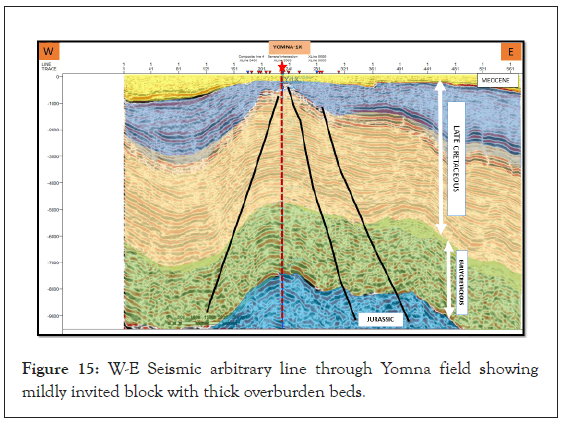
Figure 15: W-E Seismic arbitrary line through Yomna field showing mildly invited block with thick overburden beds.
The relationships between inversion, trapping, and oil migration, the two structures (Mubarak and Gindi) have been stylized, which play the impact role of the main components of the petroleum system in both inverted areas. First of them which is more severe inversion Mubarak anticline has a migration that the charge from the footwall to the hanging wall anticline is very limited because the footwall developed a synclinal geometry. The majority of mature hydrocarbons will migrate away from the hanging wall and only a limited kitchen area adjacent to the fault will thus be available for charging the hanging wall structures.
The hanging wall anticline may also be charge limited from the Jurassic due to the presence of a tight Masajid limestone top seal. The major anticline is effectively charge de-focused for the Jurassic, because hydrocarbons migrate laterally up-dip away from the structure. However, any structure that is present due to inversion on antithetic faults at the edges of the half-graben may receive charge, where it is focused beneath the reservoir. Younger source-rocks such as the Abu Roash become mature where there has been significant syn-inversion deposition and burial, which is typically in basinal synclines between inversion anticlines. In structures such as the Mubarak anticline, hydrocarbons will migrate from the kitchens toward any adjacent structural high, and hence, the shallower Abu Roash reservoirs are more likely to be charged (e.g., the Karama fields located on the southern margin of the inversion). A compressional tectonic phase (tectonic inversion) related to the Laramide tectonic event strongly affected the upper cretaceous sedimentary succession in the entire sedimentary basins in the northern Western Desert including the Gindi Basin and Mubarak sub-basin. This compressional episode started during the Santonian age and continued through the early tertiary because of NW-SE compressive stress related to the movement of Africa relative to Laurasia. This tectonic plays the important role to construct the most of oil trapping in different fields like Yomna field, according seismic re-interpretation, and constructed Geological cross section of this block illustrated the role of structure to generate prospects (Figures 16 and 17).
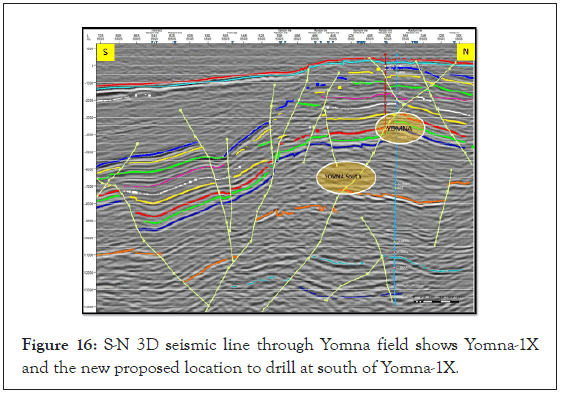
Figure 16: S-N 3D seismic line through Yomna field shows Yomna-1X and the new proposed location to drill at south of Yomna-1X.
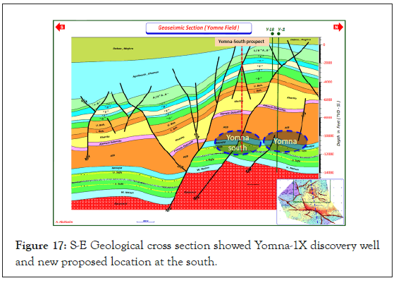
Figure 17: S-E Geological cross section showed Yomna-1X discovery well and new proposed location at the south.
The discovery well Yomna-1X was drilled on the crest of the structure. The structure analysis of this field can to proposed a new prospect to the south block which nominate Yomna south, Yomna Structure is a faulted three-way dip closure on top Khatatba showed in Figure 18.
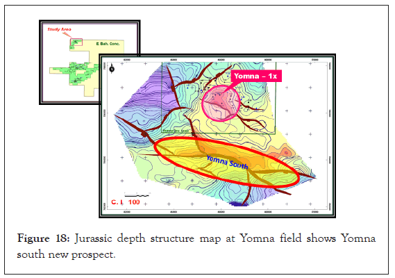
Figure 18: Jurassic depth structure map at Yomna field shows Yomna south new prospect.
In Yomna-1X well showed more than 50 ft. Sandstones with oil shows while drilling in upper and lower Safa Members. Petro physical evaluation for the well Yomna-1X showed that the well has encountered more than 20 ft. of oil bearing Sandstones against Upper and Lower Safa Members. This evaluation controlled by applied a value of porosity cut off (6,7 and 8%) which provided in volume calculation through the different net pay maps.
The main regional top seal in the study area are represent by Apollonia carbonates, and Khoman chalk, where Apollonia and Khoman are thick oil prospectively and potentiality are high, The Apollonia Isopach map showed that the Apollonia depocenter and is very thick to the south of the Gindi basin, that has a ENE- WSW structural trend, the isopach map of the Maastrichtian sediments of the Khoman formation is more complicated than those of the older Mesozoic unit (Figures 19 and 20).
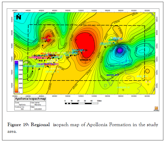
Figure 19: Regional isopach map of Apollonia Formation in the study area.
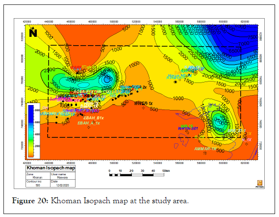
Figure 20: Khoman Isopach map at the study area.
As the Jurassic source rocks are widely distributed in the northern and northwestern parts of the study area, they are considered the main source for hydrocarbon exploration in Mubarak sub basin and the Upper Cretaceous Abu Roash “F” member forms a source rock with an advantage in being distributed throughout the entire area reservoirs. The most is believed that hydrocarbons were generated in the Gindi basin from source beds within the Lower Kharita shales, and possibly Jurassic (Khatatba formation) to the north part of the study area, in addition to A/R “F” carbonates (Figure 12), but in Abu Gharadig basin (Mubarak sub-basin) oil has been generated from Jurassic (Khatatba formation, in addition to A/R “F” carbonates, which subsequently migrated into the different traps located in the up dip locations of the flanks of the basin figure ARF source rock map is seemed thick in the NE and W direction of the study area, the oil window for ARF source expected at the depth interval from 4500 ft. to 5500 ft.) (Figures 21 and 22).
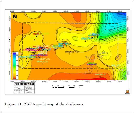
Figure 21: ARF Isopach map at the study area.
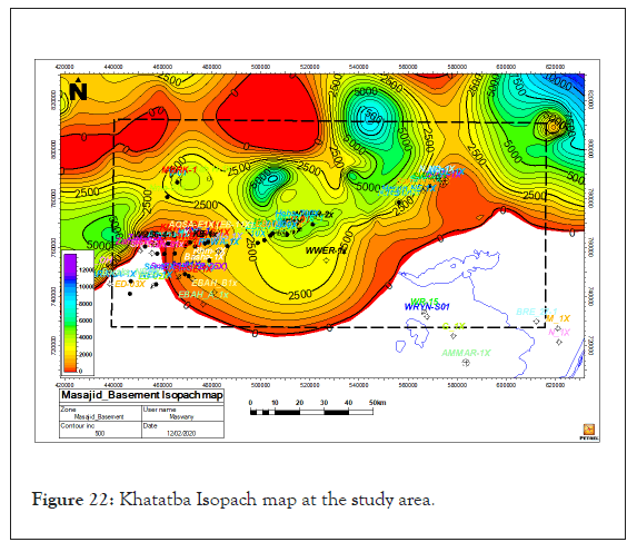
Figure 22: Khatatba Isopach map at the study area.
Paleo-structural evolution of study area
The Paleo-structural evolution during different ages which show the inversion that took place during Khoman deposition time. Tectonic evaluation of the area during the Paleozoic time is not understood due to the limited number of drilled deep wells in the study area. The most important tectonic event affecting the study area occurred during the late cretaceous and early tertiary periods, and is a part of the movement is believed to be related to the movement of North African plate toward Europe (Alpine orogeny, this compressional movement caused the elevation and folding of major portions of the Northern Western. The tectonic evaluation of the study area affected by three phases. The first phase is represented by the structure of the Basement fabric and rejuvenated throw the over burden section that exhibits NE-SW trending faults with the black color. The second phase represented by Late Jurassic to Early Cretaceous rifting and is represented by the NESW trending faults with the red color. The third phase is represented by Late Cretaceous rifting and is represented by the dominant NW-SE trending. The NW-SE seismic line in Figures 20 and 21 illustrates of tectonic evaluation in NW corner in the study area in the following stages:
Stage 1: By the end of the time of deposition of Top Masajid Fm.
By that time of deposition, Yomna and Yomna-south prospects (high structure at the present) (Figures 23 and 24), flattened on top AEB (Figures 25A-25C), a structural low was existing. This low structure was represented by a half-graben at possible Jurassic, Paleozoic and Basement older levels. This structure is controlled by NE trending basement normal fault as a part of Syrian Arc System feature.
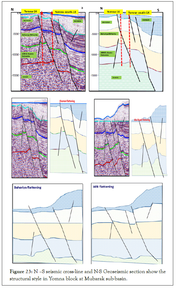
Figure 23: N –S seismic cross-line and N-S Geoseismic section show the structural style in Yomna block at Mubarak sub-basin.
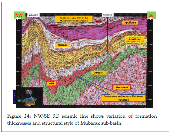
Figure 24: NW-SE 3D seismic line shows variation of formation thicknesses and structural style of Mubarak sub-basin.
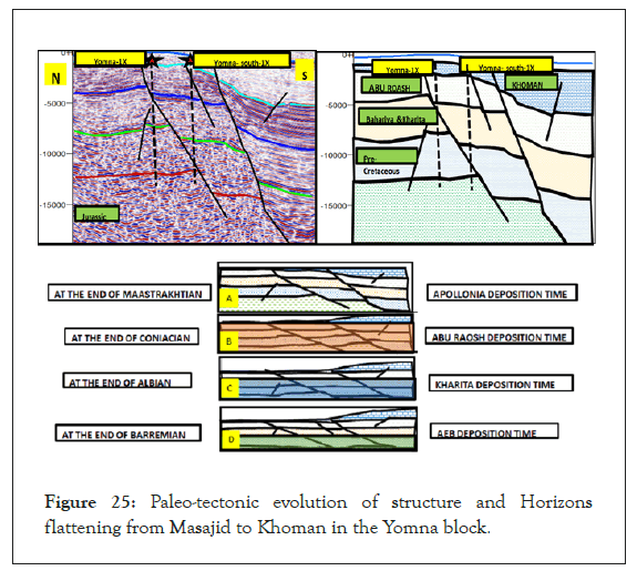
Figure 25: Paleo-tectonic evolution of structure and Horizons flattening from Masajid to Khoman in the Yomna block.
Stage 2: By the end of the time of deposition of Top Bahariya Fm. The composite 3D seismic line flattened on Bahariya formation (Figure 25C) show that the Yomna horst structure still exists at the early cretaceous.
Stage 3: By the end of the time of deposition of A/R” A” Fm. The composite 3D seismic line, flattened on top A/R” A” in Figure 25B, shows that the shaded area has four-way dip closure on A/R” G” level. In this phase the inversion tectonic movement could be noticed. This is quite supported by symmetric Anticlinal feature, in response to the continued compression and inversion. At the top of Bahariya and all other surfaces of Abu Roash formations below A/R” A” flattened horizon.
Stage 4: By the end of the time of deposition of Apollonia Fm. The composite 3D arbitrary seismic line, flattened on top Khoman in Figure 25A, this exhibits the present day structure. The compressive force reached the maximum prior to the advent of Khoman Sea, resulted in the area pronounced four-way dip structure closure sealed by itself. The study area is affected by the compressional forces of the Syrian Arc System of folding that took place during Santonian-M. Eocene, resulted in the formation of inverted structures that are pronounced at the A/R” G” level and mild at the A/R” A” and Khoman level in the study area (Figure 24).
Hydrocarbon trapping and the role of fault trends
The re-interpretation of 3D seismic data at the East Bahariya concession, to build the different structure and isopach maps. Interpreted ARG and upper Bahariya formations that consider the main reservoir in this area. Upper Bahariya structure map illustrate that due to the lateral movement the most oil traps were formed in the three-way dip closures in NW-SE trend (white circles) on the NE-SW main fault. By the structure of the Basement fabric and rejuvenated throw the over burden section that exhibits NE-SW trending faults with the black color (Figures 26 and 27).
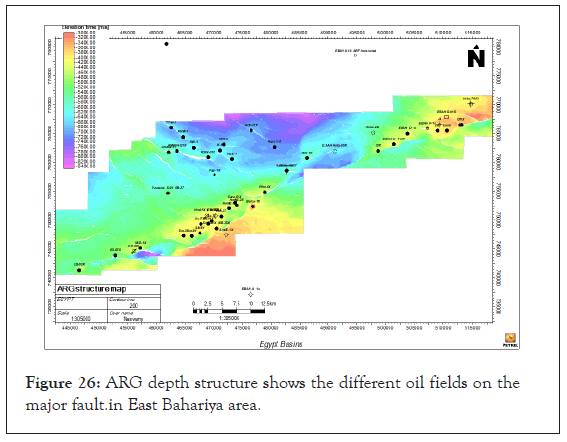
Figure 26: ARG depth structure shows the different oil fields on the major fault.in East Bahariya area.
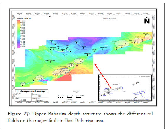
Figure 27: Upper Bahariya depth structure shows the different oil fields on the major fault in East Bahariya area.
In the Western Desert, Jurassic to early cretaceous deposition occurred in a series of half-graben bounded mainly by south-dipping extensional faults that are counter-regional to the Tethys passive continental margin to the north. This study area has oriented in Jurassic to Cretaceous extension and has been subsequently inverted during the Late Cretaceous (WNW–ESE compression) to Oligocene (NW–SE compression. Inversion tectonics occurred in two phases: the first phase occurred during the Santonian, marked by the top Khoman unconformity, which resulted due to an uplift and erosion; and the second phase took place during the early tertiary, where the inversion was synchronous with significant basin growth in the Abu Gharadig and Gindi Basins. This resulted in thick Khoman to Apollonia deposition and burial/maturation of the Abu Roash Member. Major normal faults formed in the early rift phase (e.g., basin/rift-bounding faults), but the major reverse faults formed during basin inversion during the second phase. Platform areas that did not go through the rifting phase are still deformed by the regional compressive stress. Examples of platform compression occur in the Paleozoic basin; in the western part of the Western Desert, and the Bahariya– Diyur platform. The magnitude of basin inversion impact on the hydrocarbon potential of a given structure. In the major inversions (e.g., Kattaniya High and the north Sinai folds), the hanging wall basins are highly inverted such that the main reservoir and source-rock sections are brought to the surface, where there is no significant good cap rock (top seal) and that is the main reason of dry holes that was drilled in the highly inverted areas. Therefore, the previous mature source-rocks becoming non-generative due to the absence of thick overburden sediments. However, any less severe inversion structures that remain buried by the post-Eocene section will have a better chance of preserving the structural geometry, and therefore top seal is there (e.g. Qarun oil field). In the Mubarak anticline where the geometry of the deeper syn-rift sequences is more planar than the overlying postrift folded sediment, migration from the syn-rift source-rocks beneath the main inversion anticlines will be migrated up-dip along the interconnected pore-space and permeable formations and beneath the local top seals. Major hanging wall inversion anticlines like those have the potential to be de-focused and consequently poorly charged. In the syn-rift source-rocks which are deeply buried, the lateral charge will be directed towards the large inversion anticline that is affected by crestal extension fractures and faults, which will reduce trap integrity as well. Migration of hydrocarbons from source-rocks will also be controlled by the dip direction of beds in the inverted basin. In contrast to the synrift sequences, as post-rift kitchens tend to lie in the synclines between inversion anticlines, such that lateral migration is generally toward the anticlinal axes. These structures can therefore be more successful at shallower reservoir levels. In the Highly inverted area Khoman and Apollonia top seal rock seemed thinning and all hydrocarbon targets is shallower such as Mubarak and Asala areas but in the other areas as Qarun which mild inverted area the all targets seemed deepest.
Citation: Hussien M, Hafeez THA, Fathy M, El Ghamry MN (2021) Impact of Structural Style and Inversion Evaluation in the Prospectivity and Hydrocarbon Potentiality, at EL-Gindi and Mubarak Basins, North Western, Desert. J Geol Geophys. 10: 1001.
Received: 12-Nov-2021 Accepted: 26-Nov-2021 Published: 03-Dec-2021 , DOI: 10.35248/2381-8719.21.10.1001
Copyright: © 2021 Hussien M, et al. This is an open-access article distributed under the terms of the Creative Commons Attribution License, which permits unrestricted use, distribution, and reproduction in any medium, provided the original author and source are credited.