Journal of Geography & Natural Disasters
Open Access
ISSN: 2167-0587
ISSN: 2167-0587
Research Article - (2024)Volume 14, Issue 4
Dropping slope sectors are a sub-stable slope type which abundantly exists in mountainous regions. They develop through a deep hydrogeological process. Under strong exogenic geological down-cutting conditions, stresses are unloaded onto the slope rock mass, which then becomes loose and can be penetrated by rainwater. The rainwater in the slope rock mass congregates along the water table. The rock mass around the water table is argillized and then compressed due to the gravity from the upper part. The upper part drops gradually as the rock mass is compressed. In the slope rock mass with even structures dropping slope sectors exhibit in a fan-like shape with a backward curve trench on its back. Dropping slope sectors may be vulnerable to deformation, collapse, and landslide, particularly when a strong earthquake occurs. Numerous types of structures suffer from this type of geohazard risk. The three parallel rivers region is the key research region in this study.
Dropping slope sector; Deep hydrogeological process; Landslide; Geological structure; Three parallel rivers region; China
Dropping slope sectors are a newly recognized sub-stable slope type in the three parallel rivers region, Southwestern China [1,2]. The three parallel rivers include the Nujiang, Lancangjiang, and Jinshajiang Rivers [3,4]. To the author’s sbest knowledge, little research has dealt with this sub-stable slope type [5-11]. Dropping slope sectors with sub-stable nature may gradually evolve as an unstable slope. The development of dropping slope sector is closely related to geohazards, particularly in high mountainous regions [2]. Dropping slope sectors exist at a large scale along high steep slopes, especially in the gorge sector of river valleys. The development of dropping slope sectors can impose catastrophic geohazard risks since many types of structures are constructed in high mountainous regions. Thus, more research efforts should be made to examine the formation of dropping slope sectors and the associated geohazard risks.
Based on a prior work in the Three Gorges Region, a similar methodology was carried out in the Three Parallel Rivers Region, Southwestern China [12].
In the research for this paper, methods mainly involve field observation, photo taking, section measurement, note keeping, comprehensive analysis and figure drawing.
Major characteristics of a dropping slope sector
Location features: Dropping slope sectors are often located at the outward bow part of mountain slopes along the convex bank of rivers. The scale of a dropping slope sector is related to the integrality, curve rate, and height of the slope. Generally, a largescale integer slope with a smooth frontward bow may develop a large dropping slope sector.
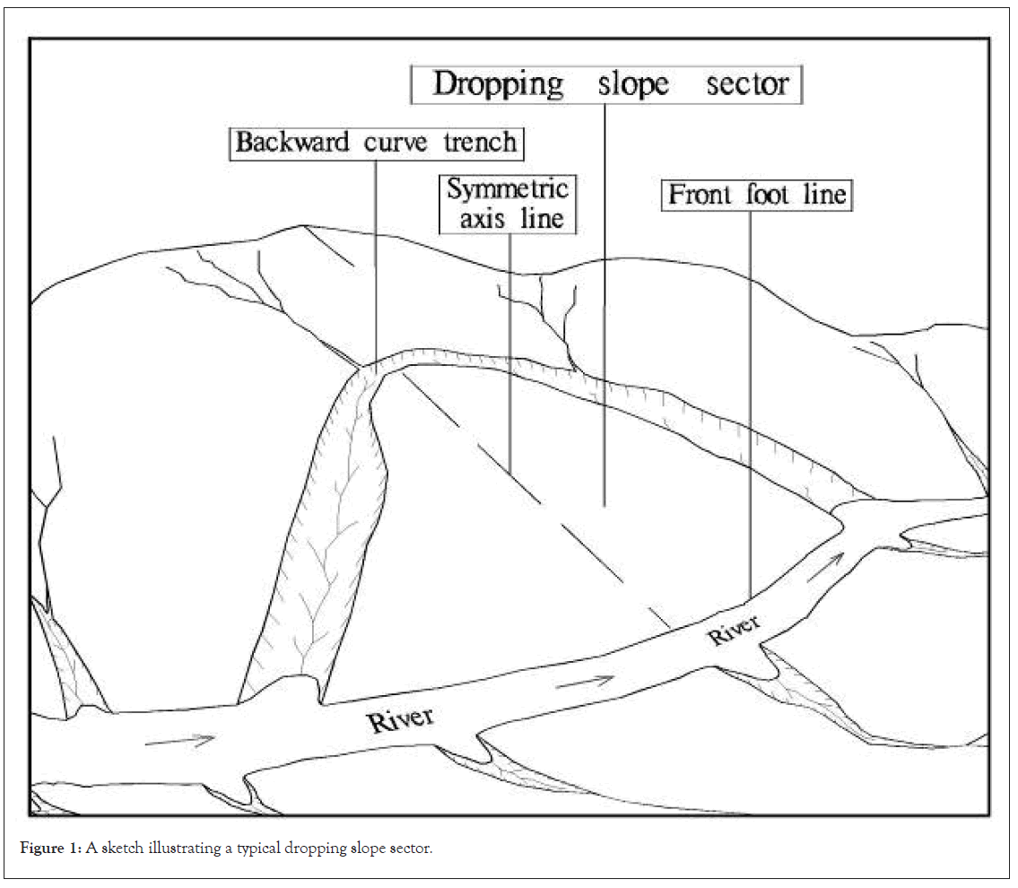
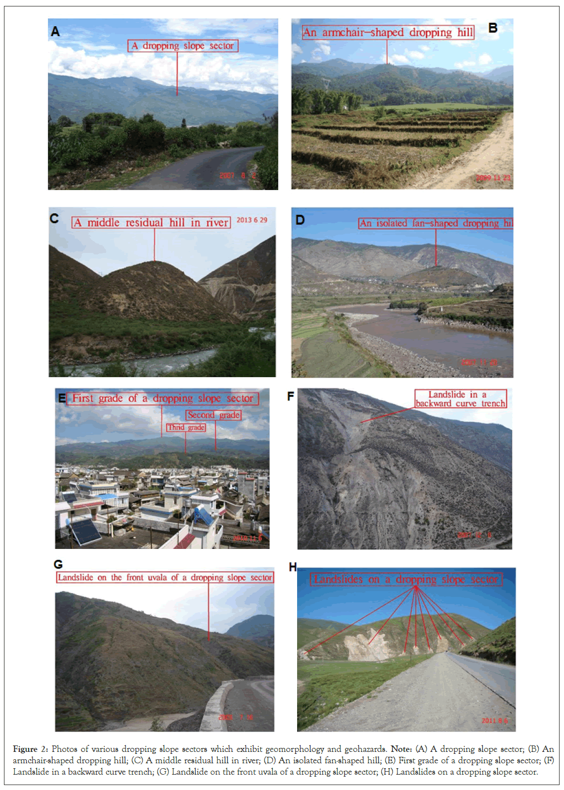
Typical shape: In its early development period, a typical dropping slope sector exhibits a fan-like shape with a backward curve trench around its back as shown in Figures 1 and 2a. The front foot line of a dropping slope sector bows toward the river. The top of a dropping slope sector is relatively flat. The backward curve trench gradually widens from the back part to the two sides near the river because of the increasing erosion strength in the trench. Compared a dropping slope sector with a landslide, the scale of an ordinary dropping slope sector is apparently larger than the scale of an ordinary landslide.

Figure 1: A sketch illustrating a typical dropping slope sector.
(a) A dropping slope sector on J3 and K1 argillicious sandstone that is 4 km long from SE to NW, 3.5 km wide from SW to NE, and has a 7 km2 area in Shaping Village, Xiajie Town, Yangbi County, Yunnan Province (250° view, photographed at 99°59′55″E, 25°39′13″N); (b) Armchair-shaped dropping hill on γ5 granite in SE Gongsongsishe, Jiemao Village, Longzhang Town, Yingjiang County, Yunnan Province (145° view, photographed at 97°47′55″E, 24°31′46″N); (c) Middle residual hill induced by the migration of the Maqu River to the backward curve trench of the dropping slope sector in the north of Dujiaolong Village, Xiaqiong Town, Batang County, Sichuan Province (15° view, photographed at 99°8′26″E, 30°2′10″N); (d) Isolated fun-shaped dropping hill in Biaocun Village, Biaocun Township, Yunlong County, Yunnan Province (345° view, photographed at 99°7′37″E, 26°2′27″N); (e) Multi Sub-grade dropping slope sector on γ51 granite in Hejiafeng Village, Fengshan Town, Fengqing County, Yunnan Province (40° view, photographed at 99°54′28″E, 24°35′55″N); (f) Landslide in the backward curve trench of the dropping slope sector on the right bank of Lancangjiang River in the south of Ricu Village, Yunling Township, Deqin County, Yunnan Province (245° view, photographed at 98°51′55″E, 28°17′12″N); (g) Landslide at the front uvala of the dropping slope sector on J2 argillicious sandstone that is 3 km long, 2 km wide, and has a 3 km2 area on the lift bank of the Jinshajiang River in Daludi Village, Taoyuan Township, Yongsheng County, Yunnan Province (80° view, photographed at 100°37′47″E, 26°11′37″N); (h) Landslides that occurred on the slope of the dropping slope sector on calcerous sandstone trigged by the 2010 Yushu M 7.1 earthquake in Quecanda Village, Jiegu Town, Yushu County, Qinghai Province (280° view, photographed at 96°52′17″E, 33°3′41″N).
Variable shapes: A dropping slope sector transforms uninterruptedly. A dropping slope sector evolves as an armchairshaped dropping hill as shown in Figure 2b, middle residual hill in a river as shown in Figure 2c, isolated fun-shaped dropping hill as shown in Figure 2d, or multi-grade dropping slope sector as shown in Figures 2e-2h.
Lithologic and tectonic characteristics of a dropping slope sector
Dropping slope sectors vary significantly with rock types, with larger sectors commonly forming in softer rocks like argillaceous sandstone or sandy argillite due to their lower resistance to erosion and weathering. The lithology influences both the scale and stability of the slope.
Lithologic features: Different rocks develop dropping slope sectors with different scales. Large dropping slope sectors often develop in argillaceous sandstone or sandy argillite.
Argillaceous sandstone and sandy argillite are vastly distributed in the three parallel rivers region [13-15]. Hence, large dropping slope sectors develop abundantly in this area.
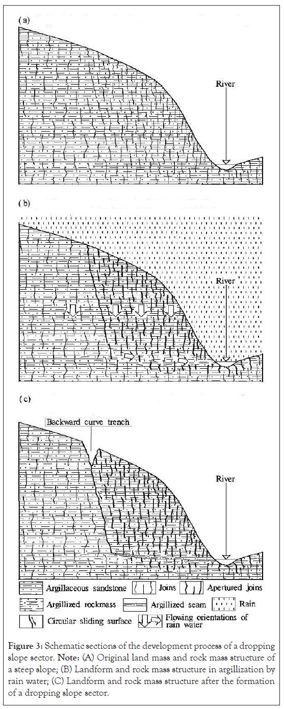
Tectonic features: The development of a dropping slope sector is closely related to the regional tectonic features. The rock around a large dropping slope sector often bears a smoothly inclined stratification and is often severely fractured by joints or cleavable zones in geo historic periods as shown in Figure 3a. Even largescale dropping slope sector can develop in the granite region if the granite is severely fractured as shown in Figures 2b and 2e.

Figure 2: Photos of various dropping slope sectors which exhibit geomorphology and geohazards. Note: (A) A dropping slope sector; (B) An armchair-shaped dropping hill; (C) A middle residual hill in river; (D) An isolated fan-shaped hill; (E) First grade of a dropping slope sector; (F) Landslide in a backward curve trench; (G) Landslide on the front uvala of a dropping slope sector; (H) Landslides on a dropping slope sector.

Figure 3: Schematic sections of the development process of a dropping slope sector. Note: (A) Original land mass and rock mass structure of a steep slope; (B) Landform and rock mass structure in argillization by rain water; (C) Landform and rock mass structure after the formation of a dropping slope sector.
The crust in the region with abundant dropping slope sectors often experienced a strong uplift movement in the neotectonic movement period. Because of the uplift movement, the local basis level of erosion dropped. Consequently, the landform suffered a strong exogenic geological down-cutting process in the region.
Formation of dropping slope sectors
General formation: A dropping slope sector was discovered in the Three Gorges Region by the author Zhang [12,16]. The development of a dropping slope sector can be summarized as follows:
Under the strong exogenic down-cutting geological circumstance in the mountainous region, the stress in the slope rock mass is unloaded. Consequently, the fractured slope rock mass is relaxed and apertured [17]. Water penetrates the apertured rock mass when it rains. In the upper part of the slope rock mass with a flat top, water penetrates abundantly and rapidly into the rock mass in a vertical direction as shown in Figure 3b. In the bottom part of the slope rock mass, water aggregates and diverts to flow gradually in a smooth river-ward slant orientation because of the slight rock mass relaxation as well as because water confronts the river current pressure in the bottom part of the slope rock mass.
The water-rock interaction occurs in the water penetration process [12,18]. Hence, the rock mass is argillized or dissolved. Strong water-rock interaction can be adequately realized in the bottom part of the slope rock mass. Thus, an argillized seam is generated along the severely argillized zone [12].
The rock mass above the argillized seam drops gradually, and the dropping slope sector forms as shown in Figure 3c. A scarp is generated on the back of the dropping slope sector. Owing to the erosion along the scarp, a trench develops on the back of the dropping slope sector, which contributes to the fan-like shape.
Special formation: The shape of a dropping slope sector is determined by geological environment features. The shape of sector is actually irregular. A typical dropping slope sector as shown in Figure 1, develops as follows.
A dropping slope sector develops at the outward bow sector of a mountain slope along the convex bank of a river. Around the outward bow part, the slope bears a wide open free-face. The widest part of the open free-face is the symmetric axis line of the dropping slope sector. The inclination of the slope top is relatively smooth along the symmetric axis line. Hence, the relaxed slope rock mass can fully accept water penetration. The slope is narrow outside the symmetric axis line, and slope inclination is steep. Hence, water penetration into the relaxed slope rock mass is minimal.
The argillized seam generated by the argillization or dissolution of water has a large width along the symmetric axis line and a narrow width outside the symmetric axis line. Based on the mechanical principle, the dropping space of the relaxed slope rock mass above the argillized seam will be confined by a circular sliding surface in the evenly fractured rock mass [17]. The vertex of the circular sliding surface will generally locate on the symmetric axis line. The front foot line of the frontward bow slope and the backward curve trench developed from the circular sliding surface will confine the outline of the dropping slope sector, with the symmetric axis line across the center.
Geohazard risk imposed by dropping slope sectors
Geohazard risk in different conditions: The upper part of the slope rock mass in a dropping slope sector is further relaxed and apertured in the dropping process. Hence, a dropping slope sector is more vulnerable to deformation.
Under ordinary conditions, a dropping slope sector is vulnerable to partial deformation, such as collapses or small landslides. The most vulnerable landslide area is the backward curve trench around the dropping slope sector because the trench has vertical slopes and loose soil as shown in Figure 2f. Another vulnerable landslide area is the uvala of the front surface of a dropping slope sector as shown in Figure 2g because this area is full of loose soil and has a large surface that absorbs rainwater [16].
When a strong earthquake occurs, a dropping slope sector may slide entirely along the argillized seam or collapse at a large scale toward the river. When the 2008 Wenchuan M 8 earthquake occurred, many large landslides were triggered from dropping slope sector [19-22]. In the Lancangjiang River, Jinshajiang River, Shanzhai River, and many other river valleys, clay layers are often located between gravel layers [23]. The clay layers could contain the deposition of a reservoir dammed by the sliding of an entire dropping slope sector [24].
A dropping slope sector may be fractured severely or slide pervasively when a relatively strong earthquake occurs. In the 2010 Yushu M7.1 earthquake, many landslides occurred on dropping slope sectors as shown in Figure 2h.
Geohazard risk on construction: Many structure types are threatened by geohazard risks. The types of structures include hydro power station dams, bridges, highways, highway tunnels, railways, railway tunnels, and hydro canals.
If a hydro power station dam is located on a dropping slope sector, the dam may be damaged by the deformation of the dropping slope sector. The case is similar for a bridge on a dropping slope sector. If a dropping slope sector slides entirely in the reservoir of a hydro power station, the station may be destroyed completely.
If a highway passes through a dropping slope sector, the highway may be deformed or may suffer from landslides and collapse with the deformation of the dropping slope sector. If a highway tunnel passes through a dropping slope sector, the tunnel may be deformed or may suffer from water inflow and collapse. The case is similar for railways and railway tunnels within a dropping slope sector.
If a hydro canal passes through a dropping slope sector, the canal may be deformed or may suffer from landslides, collapse, and leakage.
Newly recognized dropping slope sectors develop abundantly in mountainous regions. Such sectors are mostly located at the outward bow part of a mountain slope along the convex bank of a river.
A large dropping slope sector often develops in argillaceous sandstone or sandy argillite. The rock around a large dropping slope sector is often severely fractured by joints or cleavable zones in geo historic periods.
A dropping slope sector develops through a deep hydrogeological process that involves the argillization of rain water along the water table surface near the river surface.
The fan-like shape of a dropping slope sector is determined by mechanical principles. The sliding surface on the back of a dropping slope sector is restricted to a circular surface in the evenly fractured rock mass.
A dropping slope sector is vulnerable to deformation. The most vulnerable landslide areas are the curve trench around the back and the uvala of the front surface of a dropping slope sector. When a strong earthquake occurs, a dropping slope sector may slide entirely or collapse at a large scale toward the river. Many types of structures are threatened by this type of geohazard.
The author wishes to thank Prof. Yueping Yin from China Institute of Geo-environmental Monitoring and Prof. Yongshuang Zhang from China University of Geosciences (Beijing) for the support and help in the relevant research. In addintion, the author would like to thank Chong Xu from National Institute of Natural Hazards, MEMC for the help him in improving the manuscript. Finally, the author thanks ShineWrite editors (USA), Xiaojun Yang from Florida State University and the author’s junior-Huaguo Xiao (USA) for the help in polishing the English writing quality of this paper.
This research reported in this paper was relevant to and financially supported by China Geological Survey through the grants “Evaluation and zoning map on regional crustal stability in Nujiang–Lancangjiang–Jinshajiang Region, southwestern China” (Grant No. 1212010741404), “Study on seismogeological hazards in Yingjiang, Yunnan Province, southwestern China” (Grant No. 1212010914042), and “Study on the tectonic conditions of the seismic pregnancy in the Nujiang-Lancangjiang-Jinshajiang Region, Southwestern China” (Grant No. DZLXJK201705).
Citation: Zhang J (2024). Investigation on the Dropping Slope Sector Formation and its Associated Geohazard Risks. J Geogr Nat Disasters. 14:327.
Received: 19-Nov-2024, Manuscript No. JGND-24-35265; Editor assigned: 22-Nov-2024, Pre QC No. JGND-24-35265 (PQ); Reviewed: 09-Dec-2024, QC No. JGND-24-35265; Revised: 16-Dec-2024, Manuscript No. JGND-24-35265 (R); Published: 23-Dec-2024 , DOI: 10.35841/2167-0587.24.14.327
Copyright: © 2024 Zhang J. This is an open-access article distributed under the terms of the Creative Commons Attribution License, which permits unrestricted use, distribution, and reproduction in any medium, provided the original author and source are credited.