Journal of Geology & Geophysics
Open Access
ISSN: 2381-8719
ISSN: 2381-8719
Research Article - (2018) Volume 7, Issue 5
Keywords: Porosity; Beach sand; Dune sand; Precision of measurement; Accuracy of measurement
Accurate measurement of the effective porosity in unconsolidated sediments is an important factor in estimating the hydraulic conductivity from grain size distribution, in estimation of the total and effective porosity, in calibration of certain geophysical measurements, and in making groundwater flow velocity measurements [1-3]. The first step in estimation of sediment effective porosity is to measure the total porosity. There are a number of methods to measure total porosity of unconsolidated sediments cited in the literature including the volumetric saturation method [3], the dry sediment bulk density measurement method [4] and some combinations of these methods.
In moderate to well sorted sands, the laboratory methods of determining porosity can yield very good estimates for total porosity with a minor correction to obtain effective porosity. If clay content of the sediment sample is over 1% or the sediments are poorly sorted, then the measured porosity must be corrected (reduced) to obtain an estimate for effective porosity. However, in well sorted sands that were deposited in beach and coastal dune environments, the measured total porosity is very close to the effective porosity because there is no significant quantity of mud (silt and clay) to block pore throats. Commonly, laboratory total porosity measurement methods are inherently subject to measurement errors, requiring a number of replicate measurements to ascertain that error. A standing issue is the accuracy and reproducibility of these measurements because they require a degree of mechanical compaction during the measurement process [5]. Commonly, replicate porosity measurements are not made during many hydrogeologic investigations and no measurement errors were reported. The purposes of this research were to evaluate a method that combines the volumetric saturation method with the bulk density method to yield cross-checked measured values and to test the precision and accuracy of a large number of sample measurements with replicates to assess typical measurement error. This method is dependent on sand samples having a predominantly quartz sand composition. Monomineralic sands of other compositions can be analyzed using the same method, but the bulk density of the specific predominant mineral would have to be used instead of that used for quartz.
Sediment samples analyzed
One hundred sediment samples within the sand-size range (2 to 0.0625 mm), as defined by Wentworth [6] were used to make total porosity measurements. The sediments were collected from beach and dune (coastal and interior) environments located in Florida (USA), Uruguay, Saudi Arabia, Namibia, the United Arab Emirates, Ivory Coast, and St. Vincent Island, Cape Verde Islands (Table 1). One sample was collected at each location and had a volume of at least 400 cc. The sands were generally believed to be “mature” sands containing predominantly quartz with minimal percentages of metastable minerals (e.g. carbonates or feldspars). The beach sands collected from Lacosta Island, Florida originally contained carbonate sediments that were removed using acid to leave behind a very high percentage of quartz. These samples were used in another investigation of changes in sediment composition with time and the effects on porosity and hydraulic conductivity [7].
| Sample No. | Location | Environment | Porosity-displacement method | Porosity-bulk density method | Average percentage difference | Mineralogy Test | ||
|---|---|---|---|---|---|---|---|---|
| Average | Standard deviation | Average | Standard Deviation | |||||
| 324 | Lacosta Island, FL, USA | Beach | 0.337 | 0.004 | 0.334 | 0.002 | 1.089 | Yes |
| 325 | Lacosta Island, FL, USA | Beach | 0.35 | 0.002 | 0.347 | 0.002 | 0.688 | Yes |
| 326 | Lacosta Island, FL, USA | Beach | 0.354 | 0.006 | 0.351 | 0.002 | 0.718 | Yes |
| 327 | Lacosta Island, FL, USA | Beach | 0.352 | 0.003 | 0.35 | 0.001 | 0.56 | Yes |
| 328 | Lacosta Island, FL, USA | Beach | 0.351 | 0.007 | 0.348 | 0.005 | 0.883 | Yes |
| 329 | Lacosta Island, FL, USA | Beach | 0.351 | 0.001 | 0.35 | 0.001 | 0.469 | Yes |
| 330 | Lacosta Island, FL, USA | Beach | 0.328 | 0.011 | 0.335 | 0.007 | -2.054 | Yes |
| 331 | Lacosta Island, FL, USA | Beach | 0.325 | 0.007 | 0.34 | 0.007 | -4.631 | No |
| 332 | Lacosta Island, FL, USA | Beach | 0.344 | 0.004 | 0.342 | 0.002 | 0.554 | Yes |
| 333 | Lacosta Island, FL, USA | Beach | 0.35 | 0.002 | 0.346 | 0.002 | 0.992 | Yes |
| 334 | Lacosta Island, FL, USA | Beach | 0.341 | 0.003 | 0.344 | 0.003 | -0.7 | Yes |
| 335 | Lacosta Island, FL, USA | Beach | 0.352 | 0.004 | 0.353 | 0.002 | -0.475 | Yes |
| 336 | Lacosta Island, FL, USA | Beach | 0.354 | 0.009 | 0.35 | 0.007 | 1.123 | Yes |
| 337 | Lacosta Island, FL, USA | Beach | 0.348 | 0.002 | 0.349 | 0.002 | -0.501 | Yes |
| 338 | Lacosta Island, FL, USA | Beach | 0.339 | 0.006 | 0.34 | 0.002 | -0.175 | Yes |
| 339 | Lacosta Island, FL, USA | Beach | 0.343 | 0.006 | 0.343 | 0.002 | 0.041 | Yes |
| 340 | Lacosta Island, FL, USA | Beach | 0.353 | 0.008 | 0.352 | 0.002 | 0.306 | Yes |
| 341 | Lacosta Island, FL, USA | Beach | 0.349 | 0.022 | 0.344 | 0.022 | 1.509 | Yes |
| 342 | Lacosta Island, FL, USA | Beach | 0.355 | 0.003 | 0.354 | 0.001 | 0.145 | Yes |
| 343 | Lacosta Island, FL, USA | Beach | 0.349 | 0.002 | 0.348 | 0.001 | 0.328 | Yes |
| 344 | Lacosta Island, FL, USA | Beach | 0.347 | 0.005 | 0.345 | 0.002 | 0.408 | Yes |
| 345 | Lacosta Island, FL, USA | Beach | 0.359 | 0.003 | 0.353 | 0.002 | 1.576 | Yes |
| 346 | Lacosta Island, FL, USA | Beach | 0.357 | 0.003 | 0.355 | 0.002 | 0.427 | Yes |
| 347 | Lacosta Island, FL, USA | Beach | 0.358 | 0.003 | 0.356 | 0.001 | 0.731 | Yes |
| 348 | Lacosta Island, FL, USA | Beach | 0.355 | 0.001 | 0.352 | 0.001 | 0.751 | Yes |
| 349 | Lacosta Island, FL, USA | Beach | 0.345 | 0.002 | 0.345 | 0.005 | 0.122 | Yes |
| 350 | Lacosta Island, FL, USA | Beach | 0.344 | 0.004 | 0.345 | 0.008 | -0.239 | Yes |
| 351 | Lacosta Island, FL, USA | Beach | 0.344 | 0.003 | 0.345 | 0.001 | -0.222 | Yes |
| 352 | Lacosta Island, FL, USA | Beach | 0.357 | 0.004 | 0.353 | 0.002 | 1.193 | Yes |
| 353 | Lacosta Island, FL, USA | Beach | 0.353 | 0.006 | 0.35 | 0.002 | 0.933 | Yes |
| 354 | Lacosta Island, FL, USA | Beach | 0.35 | 0.003 | 0.349 | 0.003 | 0.361 | Yes |
| 355 | Lacosta Island, FL, USA | Beach | 0.369 | 0.002 | 0.363 | 0.002 | 1.498 | Yes |
| 356 | Lacosta Island, FL, USA | Beach | 0.344 | 0.002 | 0.342 | 0.001 | 0.754 | Yes |
| 357 | Lacosta Island, FL, USA | Beach | 0.338 | 0.005 | 0.337 | 0.005 | 0.315 | Yes |
| 358 | Lacosta Island, FL, USA | Beach | 0.351 | 0.002 | 0.35 | 0.002 | 0.343 | Yes |
| 359 | Lacosta Island, FL, USA | Beach | 0.35 | 0.002 | 0.35 | 0.002 | -0.034 | Yes |
| 360 | Lacosta Island, FL, USA | Beach | 0.36 | 0.019 | 0.36 | 0.019 | -0.052 | Yes |
| 361 | Lacosta Island, FL, USA | Beach | 0.349 | 0.002 | 0.347 | 0.002 | 0.547 | Yes |
| 261 | Uruguay | Coastal Dune | 0.355 | 0.003 | 0.352 | 0.004 | 0.695 | Yes |
| 262 | Uruguay | Coastal Dune | 0.357 | 0.005 | 0.356 | 0.004 | 0.095 | Yes |
| 263 | Uruguay | Coastal Dune | 0.355 | 0.005 | 0.356 | 0.002 | -0.47 | Yes |
| 264 | Uruguay | Coastal Dune | 0.354 | 0.002 | 0.366 | 0.024 | -3.11 | No |
| 265 | Uruguay | Coastal Dune | 0.361 | 0.004 | 0.362 | 0.005 | -0.392 | Yes |
| 266 | Uruguay | Coastal Dune | 0.357 | 0.002 | 0.357 | 0.003 | 0.012 | Yes |
| 267 | Uruguay | Coastal Dune | 0.359 | 0.003 | 0.36 | 0.004 | -0.21 | Yes |
| 268 | Uruguay | Beach | 0.37 | 0.004 | 0.37 | 0.002 | -0.005 | Yes |
| 269 | Uruguay | Beach | 0.359 | 0.003 | 0.359 | 0.001 | 0.071 | Yes |
| 270 | Uruguay | Beach | 0.355 | 0.002 | 0.354 | 0.002 | 0.34 | Yes |
| 271 | Uruguay | Beach | 0.355 | 0.003 | 0.354 | 0.002 | 0.466 | Yes |
| 272 | Uruguay | Coastal Dune | 0.355 | 0.004 | 0.354 | 0.003 | 0.196 | Yes |
| 273 | Uruguay | Coastal Dune | 0.355 | 0.002 | 0.352 | 0.001 | 0.91 | Yes |
| 274 | Uruguay | Coastal Dune | 0.357 | 0.004 | 0.356 | 0.002 | 0.215 | Yes |
| 275 | Uruguay | Coastal Dune | 0.356 | 0.001 | 0.356 | 0.003 | -0.005 | Yes |
| 276 | Uruguay | Coastal Dune | 0.357 | 0.002 | 0.357 | 0.001 | -0.061 | Yes |
| 277 | Uruguay | Coastal Dune | 0.358 | 0.003 | 0.356 | 0.001 | 0.723 | Yes |
| 238 | Uruguay | Beach | 0.335 | 0.009 | 0.34 | 0.008 | -1.33 | Yes |
| 239 | Uruguay | Coastal Dune | 0.323 | 0.004 | 0.328 | 0.002 | -0.45 | Yes |
| 240 | Uruguay | Beach | 0.34 | 0.004 | 0.338 | 0.003 | 0.763 | Yes |
| 241 | Uruguay | Beach | 0.347 | 0.004 | 0.347 | 0.002 | 0.189 | Yes |
| 242 | Uruguay | Coastal Dune | 0.337 | 0.003 | 0.335 | 0.002 | 0.59 | Yes |
| 243 | Uruguay | Coastal Dune | 0.342 | 0.003 | 0.33 | 0 | 3.642 | No |
| 254 | Uruguay | Coastal Dune | 0.351 | 0.002 | 0.351 | 0.001 | -0.212 | Yes |
| 255 | Uruguay | Beach | 0.349 | 0.003 | 0.348 | 0.002 | 0.202 | Yes |
| 256 | Uruguay | Beach | 0.349 | 0.003 | 0.351 | 0.001 | -0.459 | Yes |
| 257 | Uruguay | Beach | 0.348 | 0.003 | 0.348 | 0 | 0.357 | Yes |
| 258 | Uruguay | Beach | 0.348 | 0.002 | 0.346 | 0.001 | 0.598 | Yes |
| 259 | Uruguay | Coastal Dune | 0.351 | 0.004 | 0.348 | 0.003 | 1.017 | Yes |
| 363 | Uruguay | Beach | 0.359 | 0.001 | 0.359 | 0.001 | 0.073 | Yes |
| 364 | Uruguay | Beach | 0.356 | 0.005 | 0.352 | 0.002 | 1.069 | Yes |
| 365 | Uruguay | Beach | 0.353 | 0.005 | 0.353 | 0.004 | 0.027 | Yes |
| 366 | Uruguay | Beach | 0.358 | 0.002 | 0.356 | 0.003 | 0.582 | Yes |
| 367 | Uruguay | Beach | 0.351 | 0.004 | 0.346 | 0.002 | 1.202 | Yes |
| 368 | Uruguay | Coastal Dune | 0.348 | 0.005 | 0.348 | 0.002 | -0.282 | Yes |
| 369 | Uruguay | Coastal Dune | 0.353 | 0.006 | 0.356 | 0.001 | -0.938 | Yes |
| 370 | Uruguay | Coastal Dune | 0.352 | 0.003 | 0.35 | 0.002 | 0.71 | Yes |
| 371 | Uruguay | Coastal Dune | 0.358 | 0.004 | 0.357 | 0.006 | 0.281 | Yes |
| 372 | Uruguay | Coastal Dune | 0.357 | 0.003 | 0.354 | 0.004 | 0.672 | Yes |
| 373 | Uruguay | Coastal Dune | 0.355 | 0.003 | 0.348 | 0.002 | 2 | Yes |
| 158 | Uruguay | Beach | 0.354 | 0.003 | 0.348 | 0.004 | 1.561 | Yes |
| 159 | Uruguay | Coastal Dune | 0.351 | 0.006 | 0.351 | 0.004 | 0.077 | Yes |
| 160 | Uruguay | Coastal Dune | 0.344 | 0.002 | 0.358 | 0.002 | -3.819 | Yes |
| 161 | Uruguay | Coastal Dune | 0.355 | 0.003 | 0.354 | 0.003 | 0.242 | Yes |
| 246 | Saudi Arabia | Coastal Dune | 0.319 | 0.004 | 0.314 | 0.002 | 1.792 | Yes |
| 247 | Saudi Arabia | Coastal Dune | 0.328 | 0.004 | 0.326 | 0.001 | 0.762 | Yes |
| 248 | Saudi Arabia | Coastal Dune | 0.323 | 0.001 | 0.318 | 0.003 | 1.609 | Yes |
| 249 | Saudi Arabia | Coastal Dune | 0.337 | 0.005 | 0.335 | 0.002 | 0.245 | Yes |
| 250 | Saudi Arabia | Coastal Dune | 0.305 | 0.005 | 0.306 | 0.005 | -0.542 | Yes |
| 376 | Namibia | Beach | 0.356 | 0.003 | 0.358 | 0.002 | -0.632 | Yes |
| 377 | Namibia | Coastal Dune | 0.369 | 0.002 | 0.357 | 0.001 | 3.291 | No |
| 378 | Namibia | Coastal Dune | 0.378 | 0.003 | 0.362 | 0.001 | 4.201 | No |
| 379 | Namibia | Coastal Dune | 0.369 | 0.001 | 0.35 | 0.002 | 5.039 | No |
| 380 | Namibia | Coastal Dune | 0.373 | 0.002 | 0.334 | 0.003 | 10.375 | No |
| 381 | Angola | Beach | 0.355 | 0.004 | 0.356 | 0.002 | -0.317 | Yes |
| 211 | United Arab Emirates | Dune | 0.36 | 0.003 | 0.356 | 0.002 | 1.0338 | Yes |
| 383 | Ivory Coast | Beach | 0.385 | 0.004 | 0.384 | 0.003 | 0.271 | Yes |
| 384 | St. Vincent Island | Beach | 0.375 | 0.003 | 0.352 | 0.003 | 6.702 | No |
| 385 | St. Vincent Island | Coastal Dune | 0.379 | 0.004 | 0.348 | 0.006 | 8.311 | No |
| 386 | St. Vincent Island | Coastal Dune | 0.414 | 0.002 | 0.419 | 0.001 | -1.079 | Yes |
| 152 | United Arab Emirates | Dune | 0.34 | 0.007 | 0.343 | 0.005 | -0.866 | Yes |
| 157 | United Arab Emirates | Dune | 0.352 | 0.004 | 0.349 | 0.003 | 0.727 | Yes |
Table 1: Measurements of the total porosity of beach and dune sediment using the combined volumetric displacement and bulk density methods.
Analysis procedure
The measurement procedure was as follows:
1) Weigh an oven-dried sand sample with an ideal weight range of between 400 and 500 g (Vs) or between 200 and 300 cm3 by volume.
2) Place 200 mL of water into a 500 mL graduated cylinder (for smaller samples a 250 mL cylinder can be used with less water to improve accuracy of the measurements).
3) Slowly add the pre-weighed sand sample into the 500 mL graduated cylinder than contains the 200 mL (cc) of water.
4) No more than 75 cm3 should be added incrementally before stopping to allow air bubbles to be released and to allow some mechanical compaction.
5) After adding a volume of sediment to the cylinder, lightly tap the side of the cylinder using a small rubber mallet to drive out any air bubbles and to provide a relatively uniform degree of compaction (compaction can be observed as the layer of sediment stabilizes in the cylinder).
6) Incrementally add sand to the cylinder until the entire sample has been transferred following the described procedure.
7) Measure the volume of sand (Vs) in the cylinder (cm3).
8) Measure the total volume of sediment and water in the cylinder.
9) Subtract the sediment volume from the total volume to obtain the volume of excess water.
10) Subtract the excess water volume from 200 mL to get Vw.
11) Use Equation 1 to obtain the porosity by the volumetric saturation method (Pv).
12) Multiply the measured volume of the sand (Vs) by 2.65 (bulk density of non-porous quartz) to obtain the weight of the volume of pure quartz for the measured volume (Wq).
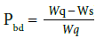
13) Subtract the measured weight of the sand volume (Ws) from the weight of pure quartz obtained from the bulk density of that volume (Wq) and divide by this same weight to obtain the porosity by the bulk density measure (Equation 2).
 (1)
(1)
Where Pv is the porosity obtained by the volumetric saturation method, Vw is the corrected volume of water obtained by subtracting the sediment volume from the total volume to obtain the excess water and then subtracting the excess water volume from the added volume, and Vs is the volume of sand.
 (2)
(2)
Where Pbd is the porosity using the bulk density method, Wq is the weight of the measured volume of pure quartz in g with a bulk density of 2.65 g/cm3 and Ws is the weight of the measured volume of quartz sand in the column in g.
To reduce calculation errors, a spreadsheet program was written by the authors that requires the entry of only four measurements and automatically calculates the two porosity measurements and compares them to produce a percentage of difference.
The four measurements are:
1) Weight of the container filled with sediment.
2) Weight of the container.
3) Total volume of the combined water and sediment in the graduated cylinder.
4) Volume of sediment in the cylinder. The spreadsheet program is given in the Supplemental Materials.
A series of 100 samples of sediment were evaluated. A series of five independent replicate measurements were made on each sample using the described method producing 500 individual measurements of total porosity. To determine the 500 total porosity measurements, a total of 2000 actual measurements of parameters in the equations were made. The statistical errors of measurement were assessed by comparing the results of the two methods to ascertain the error including calculation of the standard deviation for the five measurements of each sample for both methods. The value of total porosity used should be the average of the two measurements and the effective porosity would be reported as the same as the total porosity for well-sorted beach and dune sands.
The total porosity measurements made using the two measurements were compared statistically to ascertain their precision and error differential and the correlation coefficients R2 and p-value were determined.
Measurement results
All measurements of total porosity by both the wet volumetric and bulk density methods are reported in a spreadsheet contained in the Supplemental Materials. The average of the five measurements for both methods, the standard deviations of these measurements and the differences between the two methods as a percentage are given in Table 1.
A key aspect of the methodology used is that the sand composition must be predominantly quartz sand with a bulk density of 2.65 g/cm3, otherwise there can be a significant difference between the volumetric displacement method and the bulk density method. Based on the results given in Table 1, 91 of the samples showed less than 3% difference between the comparative averages of the two methods. Nine samples had a greater than 3% difference which shows that the sand samples contained a significant percentage of one or more minerals having a different bulk density compared to quartz [8]. The difference in sample 331 was caused by the presence of a small percentage of nodular phosphorite apparently that was resistant to removal by the acidification and remained in the sediment. Samples 264 and 243 contained some carbonate sand grains with a sufficient enough percentage to show a difference between the methods. The Namibian coastal dune sands contained a significant percentage of iron (magnetite) that caused the deviation between the methods used. The St. Vincent Island sands contained some granular pumice and carbonate grains that caused the bulk density to deviate from quartz sand.
Precision and accuracy
The average of the standard deviations for the 100 samples with 5 replicate measurements was 0.004 for the volumetric displacement method and 0.003 for the bulk density method. This demonstrates that the accuracy and precision of the total porosity measurements were observed to be very good for the sand samples measured.
A comparison of the percentage difference between the averages of the two methods produced a high degree of correspondence (Table 1, Figure 1). When the 9 samples that did not meet the mineralogy test for the sample being predominantly quartz sand are removed from the comparison, the average of the of the percentage difference between the two methods of the 91 remaining samples shows a mean error of 0.638%. The graphic comparison between the two methods showing all 500 measurements including those not meeting the monomineralic composition shows an R2 value of 0.72. When the 9 measurements that represent samples that do not meet the monomineralic composition criterion are removed, the R2 value increases to 0.91. Both correlations shows p-values significantly lower than 0.05, respectively, indicating a strong statistical correlation (2.73E-141 and 5.01E-241).

Figure 1: Cross plot of 500 measurements of total porosity using the combined volumetric displacement and bulk density methods.
There are two potential measurement errors that cause differences between the volumetric displacement and bulk density methods. First, the accuracy of the volume measurement is the primary source of error in both the volumetric saturation and the bulk density methods when measured together. The volume of sediment in the cylinder can be measured independently in the dry state to provide an independent measurement of the bulk density method. The volume of water within the graduated cylinder must be precisely measured, so large samples are preferred over smaller ones. This can be difficult when the sediment within the cylinder has an uneven and slanted surface. When sample volumes are over 250 cm3, a 500 cm3 (mL) graduated cylinder can be used, but smaller volume samples require the use of a 250 cm3 graduated cylinder to minimize measurement error. Second, weight determination of the samples produces the primary error in measuring the porosity by bulk density method.
Error produced by mineral composition
Quartz has a bulk density of 2.65 g/cm3 and has the highest percentage in mature beach and dune sands. Commonly, trace amounts of feldspars occur in beach and dune sands, but as shown in Table 2, the bulk density of the feldspar group of minerals generally has similar values of bulk density compared to quartz, so therefore, the sediment can contain up to about 15% of these minerals without causing a greater than 3% difference between the measurement methods. Lesser percentages of the common carbonate minerals will cause the difference between the methods to increase above 3%. Other higher density minerals, such as apatite or olivine (or trace percentages of heavy minerals) will cause a deviation to occur based on a small percentage within the sediment because of their higher density.
| Mineral (or group) | Bulk Density (g/cm3) |
|---|---|
| Quartz | 2.65 |
| Potassium Feldspar Group | |
| -Microcline | 2.56-2.63 |
| -Orthoclase | 2.55-2.63 |
| -Sanidine | 2.56-2.62 |
| -High Sanidine | 2.56-2.62 |
| Plagioclase Feldspar Group | |
| -High Temperature Albite | 2.62 |
| -Albite | 2.63 |
| -Anorthite | 2.76 |
| Carbonates | |
| -Calcite | 2.715 |
| -Aragonite | 2.93 |
| -Dolomite | 2.86-(2.93) |
| Other Minerals | |
| -Olivine | 3.22-4.39 |
| -Apatite | 3.10-3.35 |
Table 2: Bulk density of common minerals in sand deposits [8].
Usefulness of the combined total porosity measurement method presented
The laboratory method described to combine the volumetric saturation method with the bulk density method to determine total porosity allows a single combined measurement to be used for estimation purposes. If the two values fall below a 3% difference, then the samples pass the equivalent mineralogy test based on bulk density being close to the of pure quartz. If the difference is less than 1%, then the estimation error should be less than 0.5% when the average of the two values is used. When the difference is less than 1%, it may not necessary to perform another analysis. However, if the difference is greater than 1%, the performance of several replicate measurements may increase the accuracy of the estimate. When the two methods produce close values, they can be averaged to provide the best estimate. However, it must be clearly understood that when the combined method is used, there is a common source of error in both methods which is the volume measurement of the sediment. However, when the two methods are combined, if there is a significant difference in porosity estimates, the error is commonly caused by incorrect measurement which causes a second measurement to be made for confirmation which is quite useful and may eliminate “...the need to be replicate measurements”.
Beach and dune sands were selected for this investigation because they are known to have a high degree of sorting [9,10]. In these types of sediment, the total porosity measured is very close to the effective porosity required in many equations used to relate grain size distribution to hydraulic conductivity. When sediment samples are poorly sorted or have a median or mean grain diameter in the low range of sand-sized material as defined by Wentworth [6], standard direct laboratory methods and/or field methods should be used to determine the effective porosity [11,12]. However, the combined methods herein used can be applied to any siliciclastic sediment sample and if the error between the two methods is greater than 3%, then solely the volumetric saturation method would be used.
One of the most difficult problems in hydrogeology is to determine an accurate measurement of effective porosity at various scales. Within unlithified sands, it is possible to accurately measure the total porosity using two coordinated laboratory methods, the volumetric saturation and bulk density comparison methods, to make accurate and reproducible measurements. Where the sands are well-sorted, such as the case in beach and dunes sands, the total porosity measured is essentially the same as the effective porosity. The results from measurements for total porosity of 100 sand samples with five replicates using two laboratory methods demonstrated that a high degree of measurement accuracy and precision can be accomplished with the error being<1%. Because of the requirement of the sediment to be close to monomineralic, the bulk density method has a lower number of applications compared to the volumetric saturation method, but the combined method is useful in assessing measurement errors that can necessitate replicate measurements.