Journal of Geology & Geophysics
Open Access
ISSN: 2381-8719
ISSN: 2381-8719
Research Article - (2024)Volume 13, Issue 4
Previous studies indicates that the Paleocene-Eocene represented by the N’kapa formation in Douala onshore basin, has been a target for water supply. However, the hydrogeological research work highlights in this formation important heterogeneity linked to the nature and the geometry of the sedimentary bodies constituted the aquifer system. Taking into account the state of alteration of existing outcrops, this study aims to reconstruct a sedimentological model during the Paleocene-Eocene, using on integration of Gamma Ray (GR) well logs with outcrops data. The research methodology involved sedimentary facies described in outcrops, delineation of lithologies and identification of electrofacies corresponding to depositional environments, from GR reponses. The results obtained from this study show that the lithofacies is dominated by clays, silts and sands/sandstones. The GR log facies gave an altenating cylindrcal to funnel shaped log curve with few units of bell shapes. Also, the recognise facies associations combine by GR log pattern help to define three depositional environments that correspond to: 1) fluviatil, 2) deltaic plain and 3) delta front. The gamma ray log correlations between well to well, make it possible to determine the high-resolution geometry of the sedimentary bodies. The sedimentation reflects a fluvial to shallow marine environment dominated by fluvial processes and sometimes tidal processes. From the above results and their analysis, it is established that the sedimentary bodies which are potential aquifer, are associated with fluvial channel sands, tidal channel sands and delta front sands bars. The results obtained will be useful for rationalization of future hydrogeological research in the Douala onshore basin.
Douala onshore basin; Paleocene-Eocene; GR wireline logs; Lithofacies; Depositional environments
The Douala basin is located in the South western part of Cameroon on the West Coast of Central Africa (Figure 1). The origin of this basin will be governed by the major geodynamic events liked to opening of the equatorial Atlantic. During this great cinematic reorganization, due to the relative movements of the South American and African continents, readjustments of depositional environments are recorded in this basin. To understand the evolution of sedimentary systems, the Paleocene- Eocene series of the Douala onshore basin, have been intensively described mainly in outcrops to define a sedimentological and stratigraphic framework.
However, considering the rarity and poor quality of the outcrops, the continuous vertical depositional profil remains difficult to demonstrate. The gamma ray responses provide informations onto the natural radioactivity of rocks and therefore on their lithology. The gamma ray log pattern associated with cores drilling and outcrops data help to define the sedimentary facies and able to deduce the facies associations as well as depositional environments. This study proposes using gamma ray well logs and outcrop data, to reconstruct the paleoenvironments and to unterstand the spatiotemporal distribution of the sedimentary bodies, during Paleocene-Eocene. This time period have been a potential target of exploitation for groundwater at the eastern edge of this basin.
Given the ever-increasing economic and demographic development in the city of Douala, the demand for water is increasing. As such, a reinforcement of the geological knowledge of potential aquifers is necessary in order to better exploit them and to take relevant decisions for the rational and sustainable management of those water resources [1].
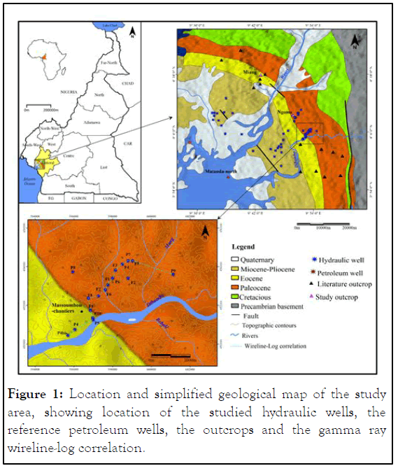
Figure 1: Location and simplified geological map of the study area, showing location of the studied hydraulic wells, the reference petroleum wells, the outcrops and the gamma ray wireline-log correlation.
Geological setting and stratigraphy
The onshore sedimentary basin of Douala is about 25 Km wide and cover a total area of 69955 Km2 (Figure 1). Three major tectonic and sedimentary episodes can be distinguished: A lower Cretaceous rift phase; a drift phase during the upper cretaceous and a short compressive episode in the tertiary period. The cretaceous to pleistocene sedimentary deposits which form outcroppings in the Douala coastal basin are discordant on a Precambrian Basement (Figure 2). The Precambrian basement which outcrops of the edge of basin is made up of syntectonic granites and calco-alkaline gneisses. In the Northwest part, it is crossed by tertiairy and recent volcanic rocks which contitute the Volcanic Line of Cameroon. It reaches 1475 m deph at the Razel 1 well, 1682 m at the Razel 2 well and is located more than 4000 m at the logbaba well. The Precambrian basement is affected by normal fault which delimit compartments whose play responds to a tectonic style in step over. The subsidence is more and more pronounced when one moves away from basement outcrops. From the edge of the basin towards the Atlantic ocean, the following sedimentary formations are distinguished (Figure 2).
The lower cretaceous (Ablian-Cenomanian), well developed at the outcrop to the North-East of the basin, are represented by sandstones and clays formations of continental origin from the erosion of the cristalline massifs. Power from 200 m to 300 m at the edge of the basin, this series reaches 700 m in thickness to the West of the basin [2].
The Turonian formations include in the lower part, an alternating of medium-grained sandstone and sandy clays with rare calcareous beds evolving upwards in an increasingly clayey sequence with intercalation on limestones levels of 15 m. In the upper part, continental sandstones are surmounted by clays with somme limestone levels. The conacian, camapanian and maestrichtian formations constitute the major part of the filling of the basin. They are made of clay with sands/sandstones intercalation from 1000 m to 2000 m thick.
The Paleocene has two sequences. A clay-sandy sequence at the top, so the thickness increases from East to West from 80 m to 170 m. A sandy and sandstones sequence at the base of 200 m to 250 m of power. Towards the South, the clay facies dominated. The base of the set is characterized by level of black clay. Downstream of the basin, a clayey marine series replaces the continental sandstones [3]. The Eocene formation have a monotonous facies consisting of marl and shale, often confused with the Paleocene (18 m to the East, 400 m to the West). Clays and sandy sequences characterize the Miocene-Pliocene formations: 200 m at the NW of Douala, 2000 m in the center of the basin. The Quaternary (Pleistocene) formations are powerful, from 50 m to 60 m, with an alternation of clay and sandy levels.
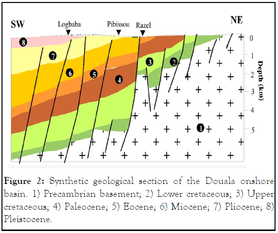
Figure 2: Synthetic geological section of the Douala onshore basin. 1) Precambrian basement; 2) Lower cretaceous; 3) Upper cretaceous; 4) Paleocene; 5) Eocene; 6) Miocene; 7) Pliocene; 8) Pleistocene.
This study is mainly based on the wireline log data and outcrop data. There are 45 hydraulic well totally in the study area so 14 have gamma ray records, provided by Cameroon Water Corporation (CAMWATER). The wells go across the Paleocene- Eocene interval with depths between 100 m to 400 m. The data from well used included gamma ray well logs, lithological description of well cuttings and the chronostratigraphic information in the well completion report. The gamma ray log reponses have been calibrated by two sedimentological sections, were removed in the localities of Ngoma and Miang (Figures 3 and 4). The data were interpreted in four steps (Figure 5) [4].
The first step was the description of different sedimentary facies and their associations. The facies are characterized in terms of grain size, sedimentary structures and paleontological content observed at the outcrop.
The second step was delineation of lithologies and identification of electrofacies corresponding to depositional environments. Lithology was determined using evidence from gamma ray wireline log characteristics. Elecrofacies were identified based upon the characteristic shapes and changes on the gamma ray curves. The third step consist at first to interpretate the depositional environment, using the standard model and at second to integrate the sedimentary facies or facies associations described from analysis of outcrops studied.
The final step was the gamma ray log correlation well to well, based on the similarity of well log curves, depositional environments and the choice of regional markers. In the continental domain, it is difficult to makes correlations because on the one hand the electrofacies vary very quickly and on the other hand there are many discontinuities. Nevertheless, in this study, the reduced spacing between wells (a few hundred meters maximum) allows for correlations [5].
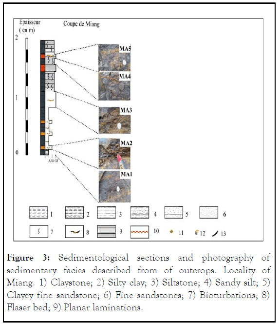
Figure 3: Sedimentological sections and photography of sedimentary facies described from of outcrops. Locality of Miang. 1) Claystone; 2) Silty clay; 3) Siltstone; 4) Sandy silt; 5) Clayey fine sandstone; 6) Fine sandstones; 7) Bioturbations; 8) Flaser bed; 9) Planar laminations.
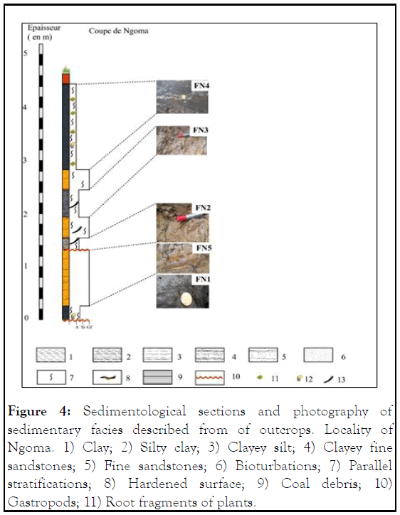
Figure 4: Sedimentological sections and photography of sedimentary facies described from of outcrops. Locality of Ngoma. 1) Clay; 2) Silty clay; 3) Clayey silt; 4) Clayey fine sandstones; 5) Fine sandstones; 6) Bioturbations; 7) Parallel stratifications; 8) Hardened surface; 9) Coal debris; 10) Gastropods; 11) Root fragments of plants.
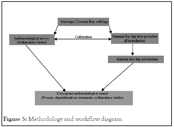
Figure 5: Methodology and workflow diagram.
Facies analysis
Within the series studied, ten sedimentary facies were recognized: Four clay facies (FN1, FN3, FN4 et MA1), three silty facies (FN2, MA2 et MA3) and three sandy/sandstones facies (FN5, MA4 et MA5). Their main characteristics are summarized in Table 1 [6].
| Outcrops | Lithofacies names | Description | Sedimentary strutures | Fossil content | Hydrodynamic process |
|---|---|---|---|---|---|
| NGOMA | FN1 | Sandy clays, dark grey, rich in organic matter | Massive, lenticular sands | Rare coal debris, pyritized moulds of bivalves and gasteropods, rare bioturbation | Deposits from suspension in the closed environment with possible tidal currents |
| FN2 | Clays with a fine sands, light grey with yellow spots and some micas | Erosive basal boundary | Root fragments of epigenized and ferruginous plants, frequent vertical bioturbations | Deposits from suspension in the closed environment with possible fluvial currents | |
| FN3 | Compact clays, light grey | Root fragments of plants responsible for frequent vertical bioturbations | Suspension-stagnation | ||
| FN4 | Compact clays, dark grey, rich in organic matter | Coal debris and moulds of gasteropods | Deposits from suspension in the closed or calm environment | ||
| FN5 | Clayey fine to medium sandstones, light grey, with subangular to subrounded gravel of quartz and some micas | Erosive basal boundary, normaly graded, horizontal laminations | Root fragments of plants responsible for frequent vertical bioturbations | Weak traction fluvial currents | |
| MIANG | MA1 | Claystone, dark with yellow to orange spots, rich in organic matter and many fine micas | Massive, lenticular and flaser silt | Rare bioturbations | Deposits from suspension |
| MA2 | Silty claystone, rich in organic matter, with white to yellow lamine of silts, some rare micas | Planar millimetric laminations silts | Deposits from suspension | ||
| MA3 | Silstones, yellow to orange with very fine sandstones, and many fine micas | Planar centimetric laminations | Frequent bioturbations | Vertical accretion at very low energy laminar flow regime | |
| MA4 | Silty sandstones, light grey, with subangular to subrounded gravel of quartz and many micas | Planar laminations | Bioturbations | Weak traction currents | |
| MA5 | Fine sandstones with clay matrix, dark grey, rich in organic matter, with subangular to subrounded gravel of quartz and many micas | Lenticular sands | Bioturbations | Lightly agitated environment at low to moderate current |
Table 1: Sedimentary facies from outcrops descriptions in Ngoma and Miang.
Facies associations analysis
The detailed study of the sedimentary facies and their relationships made it possible to identify several facies associations, each including one or more lithofacies. These different facies associations charaterize three types of sedimentary environment (AF1, AF2 and AF3): Tidal dominated coastal plain, fluvial dominated coastal plain and distal fluvial floodplain [7].
Tidal dominated coastal plain (AF1) is located at the base of Ngoma section. It consists mainly of dark grey sandy clay (FN1) and dark grey compact clays (FN4). The high content of organic matter indicates a relatively anoxic or closed environment. The presence of pyritized moulds of bivalves and gasteropod signals presence of shallow marine deposits. These two facies (FN1 and FN4) are interpreted as a deltaic plain environment or observed in estuarine environment.
Fluvial dominated coastal plain (AF2) is formed of clayey fine to medium sandstones (FN5) alternating with thin laminations of clays (FN2) and light grey compact clay (FN3). Clay facies reflect overbank and floodplains deposits. The fining-upward of sandstones facies could represent a fluvial channel-fill. The presence of roots of plants and some micas would indicate a terrigene detritic deposits. Also, the presence of bioturbations in the vertical direction and parallel stratifications are frequent. This association is interpreted as a fluvio-deltaic deposits [8].
Fluvial floodplain (AF3) is formed of facies with fine to very fine. The fluvial floodplain system is generally dominated by silt and clay deposits. They are horizontal fine sandstones (MA4 and MA5), siltstones (MA2 and MA3) and claystones (MA1) that are dominant. The facies in lithological terms reflects a gradual increase in the hydrodynamic regime. This zone characterizes a flood overflow episode at the level of floodplains. This environment corresponds as a distal fluvial floodplain or alluvial plain.
Gamma ray log analysis
Lithologic analysis: The gamma ray values from the series studied vary between 0 cps and 100 cps. The deflection to the left of the GR log signatures correspond to sandy bodies (GR lower than 5cps) and the deflection to the right signify clay bodies (GR greater than 10 cps). The GR values between 5 cps and 10 cps can be assimilated to clay-sand facies or sandy-clay facies. Globally, the gamma ray values make it possible to subdivide the Paleocene-Eocene siliciclastic sedimentation into three lithostratigraphic units: Unit 1 (lower-middle Paleocene) at the base with sandy/sandstone dominance and low radioactivity; Unit 2 (upper Paleocene-lower Eocene) is intermediate with a clay/shale or N'kapa shale dominance and high radioactivity and unit 3 (lower Eocene), mostly clay-sand to sandy-clay at the top (Figure 6) [9].
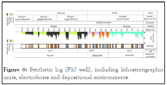
Figure 6: Synthetic log (F10 well), including lithostratigraphic units, electrofacies and depositional environments.
Electrofacies analysis: The analysis of gamma ray log pattern (electrofacies) help to deduce the facies associations and the depositinal environments. Those electrofacies determined is related to a lithofacies or specific lithofacies associations observed in outcrops (Table 2).
| Electrofacies | Characteristics | Description of Wells cuttings | Sedimentary facies | Depositinal envronment |
|---|---|---|---|---|
| EF1: Fluvial channel | Cylindrical gamma ray log curve and have almost straight curves. Serrated bell shaped | Coarse-fine sands with clays intercalations | AF2 (FN2, FN3 et FN5) | Fluviatil |
| EF2: Fluvial floodplain | Separated shaped gamma ray log curve | Sandy clay to clay | AF3 (MA1, MA2, MA3, MA4 et MA5) | Fluviatil |
| EF3: Tidal channel | Bell shape GR log curve | Silts and sands lenticular | Deltaic plain | |
| EF4: Tidal flat | Bell shaped gamma ray log curve | Clay and silt deposits | AF1(FN1 et FN4) | Deltaic plain |
| EF5: Delta front | Funnel shaped Gamma Ray log curve | Fine-grained sands and silts | Delta front |
Table 2: Facies associations-electrofacies calibration.
Fluvial channel (EF1) consists braided channel or meanderings channel. The difference between these two types or channels not obvious from GR logs curve in this work. Nevertheless, the gamma ray log curve and have almost straight curves. The meandering channel show predominantly of serrated funnel shaped log curves and sometimes serrated bell to cylindrical shaped patterns at certain intervals (Figure 6).
These intervals are also characterized by isolated sharp-based fining upwards sands bodies and develop most often on a continental fluvial environment. In the wells under study, the lithology of the fluvial channel deposits consists of coarse-fine sandy/sandstones with clay/shale intercalations.
Fluvial floodplain (EF2) is exhibited by high gamma ray log values. Such values are explained by the presence of radioactive minerals in clays. It is recognized by separated shaped gamma ray log curve and corresponds to the clay units locally separated by thin bands of sand in wells. It is interpreted as overflow deposits during flood periods [10].
Tidal channel (EF3) is characterized by bell-shaped to cylindrical gamma ray log patterns. This electrofacies represent deltaic plain deposits and erosive base. Serrated bell-shaped gamma ray log patterns result from frequent fluctuations in current strength which is common in tidal processes. In the well-cuttings, the tidal channel deposits are marked by the presence of cyclic alternation of sandstones and clay. Tidal flat (EF4) is located between facies exhibiting tidal influence. The unit is recognised by finning-upward log pattern. The tidal flat facies show sometimes bell shaped gamma ray log curve. The tidal channel is commonly associated with tidal flat and forms the deltaic plain environment. Delta front (EF5) consists predominantly of funnel shaped gamma ray log curve. The delta front facies also exhibits a typical coarsenig-upwarrds trend on the gamma ray log. The delta front deposits are generally dominated by sands and silts.
The sedimentology study of outcrops facies made it possible to define two depositional environments. The first is a fluvial environment in the locality of Miang which is characterized by distal floodplain facies. The second in the locality of Ngoma constitutes a deltaic environment dominated by fluvial and tidal processes. To establish the sedimentary bodies geometries in the series studied, two isochronous boundaries have been identified. The first at the base corresponds to the top of Selandian and is associated with erosional boundary. It consist of sharp decrease in GR values. The outcrop studies show that this surface has a thichness of about 10 cm and is formed of ferruginous concretion. The second isochronous boundary, clearly visible on the GR logs, corresponds to the flooding surface on the scale of the basin. It is characterized in outcrops by an alignment of rounded quartz pebbles. The confrontation of the sedimentary facies and the electrofacies analysis for the series studied shows the similarities and make it possible to specify the paleonvironmental fluctuations. The sedimentation reflects a deltaic progradation to a deep-open marine environment. The Paleocene-Eocene sedimentation is subdivided into two main areas (Figure 7).
The Paleocene: The continental fluvial domain, characterized by fluvial channels and deposits of overflows or floodplain. The evolution of GR responses is almost constant on fluvial channels.
The Eocene: The deltaic domain associated with tidal channel facies, tidal flat facies and delta front facies.
The evolution of GR reponses show frequency fluctuations due to tidal processes. The tidal channel and tidal flat forms the deltaic plain environnment during the period corresponds to the major eustatic rise of the Paleogene (Ypresian age). The front delta facies are make by an upward sand enrichment, which clearly reflects the evolution of GR responses.
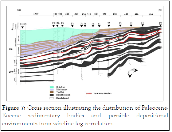
Figure 7: Cross section illustrating the distribution of Paleocene- Eocene sedimentary bodies and possible depositional environments from wireline log correlation.
The present study shows the evolution of depositional environment during the Paleocene-Eocene in the Douala onshore basin. The lithofacies is dominated by clays, silts and sands/sandstones. The sedimentation that led to establishment of the series studied began in the fluvial environment and continued in a deltaic environment. The geometries of sedimentary bodies appear to be related to the hydrodynamics and topography of the depositional environments. In absence of outcrop data in the Douala onshore basin, the wireline logs data are able to understand the evolution of sedimentary systems.
The authors would like to gratitude to the Cameroon Water Corporation (CAMWATER) for giving us access to the well data used in this study, through the convention with the University of Yaounde.
Citation: Lebogo SPKN, Bisso D, Mbida Y, Eyong TJ, Etoundi PRA (2024) Paleoenvironments and Geometry of Paleocene-Eocene Sedimentary Bodies of the Douala Onshore Basin (SW-Cameroon), from Wireline Logs Data. J Geol Geophys. 13:1178.
Received: 04-Feb-2020, Manuscript No. JGG-24-3297; Editor assigned: 07-Feb-2020, Pre QC No. JGG-24-3297 (PQ); Reviewed: 21-Feb-2020, QC No. JGG-24-3297; Revised: 03-Jun-2024, Manuscript No. JGG-24-3297 (R); Published: 30-Jun-2024 , DOI: 10.35248/2381-8719.24.13.1178
Copyright: © 2024 Lebogo SPKN, et al. This is an open-access article distributed under the terms of the Creative Commons Attribution License, which permits unrestricted use, distribution, and reproduction in any medium, provided the original author and source are credited.