Journal of Tourism & Hospitality
Open Access
ISSN: 2167-0269
ISSN: 2167-0269
Research Article - (2013) Volume 2, Issue 2
The cataloguing and promotion of rural architecture contribute to creating jobs by stimulating new economic activity, such as the promotion of cultural tourism, while preserving a valuable source of information on rural culture, recovering local construction techniques, encouraging a sense of community, and making villages and rural areas more attractive to visitors.The general aim of the present Review is to analyse agricultural and rural buildings and their properties in order to identify key issues concerning sustainable reutilisation in tourism.
It is intended to Almeria province (Andalucía, Spain) a more complete sustainable tourism development framework to satisfy all the demands, from sun and beach at the coast as well as alternative tourism at the interior, based on the protection and the valuable re-utilization of popular rural architectural heritage with potential interest for tourism purposes. Thus, a catalogue of traditional rural buildings in a particular area was carried out, identifying and characterizing each one, establishing criteria for a dynamic and rational selection.
The modelling of the lifecycle for the architectural project carried out, for the reuse of rural heritage, as a way of stimulating the tourism sector, is based on methods and risk analysis (statistical methods) and multicriteria analysis that allow the reduction in the subjectivity of the deterioration models carried out. Through the application of the Analytic Hierarchy Process (AHP), as a weighing method, a linear, weighting and additive model that combines all of the factors in one unique global assessment can be obtained, for which values have been assigned to the coefficients of the linear expression that reflect the relative importance of each factor.
Keywords: Rural Buildings, Architectural heritage, Conservation, Preservation, Cultural Tourism, Technologies
From the sixties of last century, the model of tourism at the Mediterranean coast has been sun and beach, being characterized by the existence of lot of people with acquisition power at medium-low level and specially concentrated in determined areas, in particular during summer times. During last decades, this phenomenon has changed by diverse reasons, for instance by a mentality change and the increase of free time [1].
The expansion of rural tourism is a trend that is common to most countries in Europe. Tourism is considered to be a potentially complementary activity for local communities and especially for farming families. The benefits are generally summed up as a three-way yield for the host community (the economical and social dimension of rural tourism), for the land itself (environmental maintenance), and for the tourist (leisure and tourism in the countryside), which implies a sequence of inter-related benefits. All these elements place this type of tourism within a framework of long-lasting development [1].
Tourism is considered to be one of the diversification tools in rural development [2,3]and sustainability discourses have been expanded to tourism [4]. Sustainable tourism, according to the World Tourism Organization, is: “envisaged as leading to management of all resources in such a way that economic, social and aesthetic needs can be fulfilled while maintaining cultural integrity, essential ecological processes, biological diversity, and life support systems” [5].
Sustainability in a popular building context is determined by several factors. A primary factor is that the construction industry is responsible for a large proportion of pollutants and material and energy use world-wide [6]. In addition, the qualitative characteristics of actual buildings create a long-term dependency on e.g. how energy-effectively these can be used or how often maintenance/renovation is required. Furthermore, as a result of the embodied energy in construction [7], it is more sustainable to keep and renovate e.g. former popular building rather than pulling them down and erecting new buildings. Alternatively, in the case of e.g. partial demolition, building materials can be efficiently recovered, refitted and reused, thereby reducing the environmental impact [8].
The only chance abandoned, redundant popular buildings have for survival and conservation is through utilization [9].
Monuments are undeniable documents of world history. Their thorough study is an obligation of our era to mankind’s past and future. Over the recent decades, international bodies and agencies have passed resolutions concerning the obligation for protection, conservation and restoration of monuments. The Athens Convention (1931), the Hague Agreement (1954), the Chart of Venice (1964) and the Granada Agreement (1985) are only but a few of these resolutions in which the need for geometric documentation of the monuments is also stressed, as part of their protection, study and conservation [10].
The present authors consider that the re-utilization of popular architectural heritage with tourism purposes is very positive by several reasons, mainly the recovery of old rural and industrial buildings, generally under ruination conditions. Their recovery is very valuable to get new improved buildings where an alternative tourism offer can be presented.
UNESCO (1946) and the Council of Europe have formed specialized organizations for conservation of Cultural Heritage. ICOMOS (International Council for Monuments and Sites) is the most important one, but also CIPA (International Committee for Architectural Photogrammetry), ISPRS (International Society for Photogrammetry & Remote Sensing), ICOM (International Council for Museums), ICCROM (International Centre for the Conservation and Restoration of Monuments) and UIA (International Union of Architects) are all involved in conservation task of cultural heritage [10], andthe IAPH (the Andalusian Institute of Historic Heritage), all they are involved in conservation works concerning Cultural Heritage.
In this sense, García and Ayuga[9], point out some of the most relevant positive consequences of reusing rural buildings in Spain, such as saving energy and materials, creating new jobs and economic activities, promoting cultural tourism, preserving a valuable source of documentation on rural culture, recovering local construction techniques, encouraging a sense of community and improving villages and rural scenery, making them more attractive to visit.
On the other hand, over the last few decades the European countryside has undergone profound changes. The mechanization of the agricultural sector, the modernization of facilities, the demographic shift to the cities and the ageing of the remaining inhabitants of rural areas, have brought about the decline in use and consequent dereliction of a large part of the existing traditional architecture [11]. This phenomenon is common in the rural areas of most European countries [12]. Nevertheless, we should highlight the social and cultural relevance of traditional buildings. Historic urban sites and traditional houses are the most important evidence of past lifestyles. The conservation of these traditional values within the context of preserving and revitalizing architectural heritage constitutes the preservation of culture [13]. Rural ways of living, until a few decades ago, accounted for a considerable number of land and property owners along with labourers who played a key role in the lifestyle of farming and husbandry. The buildings in these farming population centres are not isolated elements, but fit within a territorial and socio-cultural context, identifying construction methods, materials, styles, aesthetics, etc. produced by a society through the ages. However, the fact that their relevance transcends what is merely material and tangible means that this legacy can be thus preserved [14].
The primary objective of this research is to define the level of structural and architectural adaptability between man and natural environment, at a low population density scale and with a strategic level of social organization that allow their current physical continuity. The problems explained lie in how to achieve sustainable restoration, through the incorporation of multidisciplinary analysis aspects such as: the ecological, cultural and structural spectrums, in an action plan that ranges from defining the problems of each settlement to the recommendations and protective measures to be adopted for each case. The lack of a clear and precise scientific methodology to identify, select and priorities the indicators for assessing the potential of restoring popular architectural heritage has been identified.
The general aim the present review, was to analyse agricultural and rural, using Almería province (Andalusia, Spain) as an example. Specific goals are:
• To identify key factors concerning construction methods and building materials influencing the sustainable reutilisation of agricultural buildings during the renovation-refurbishment process in rural tourism enterprises.
• To account for territorial differences concerning approaches to sustainable agricultural building reutilisation in rural tourism, and study how the location affects these processes.
One of the main characteristics of rural architecture is their “utilitarian purpose”, to the extent that buildings lacking a function have tended to disappear. For this reason, reuse is a viable option for preserving this Heritage [11]. Along these lines [11,12,15-17]have devised methodologies to catalogue traditional buildings, developing identification files, printed or computerized, in which a description of the surroundings appears, as well as the location, type, materials used and graphic documents. Other research work has focused to analyse the buildings detail [11,18-21] for which graphical and visual documentation is particularly important.
A great deal of research has been focused on analysing the detail of the buildings to be reused, where the graphic and visual documentation is particularly important. The problem of decision making has become a subject of significant interest over the last few years in the field of construction. The proof of this is in the appearance of a variety of decision support models and tools, the majority equipped with a particular mathematical device using different approaches, from statistics to fuzzy mathematics, through ways of simplified quantification. The multi criteria methods (MCDA - Multi Criteria Decision Analysis) can be found in this line of work. A vast quantity of studies have been made along these lines: ORME: a methodology for multi criteria classification of buildings [22]; multi criteria material selection procedures for the items in the design project for a building, based on the Analytical Hierarchy Process method (AHP) [23]; study on the adaptive reuse and sustainability of commercial buildings by means of questionnaires and interviews [24]; decision making connected with the planning , design and construction of a building, from the perspective of the problems that the owners and professionals will face whilst considering its reuse, opting to gather information through interviews about the opinions, actions and experiences of all the parties involved in the decision making process regarding adaptive reuse [25].
Research efforts to develop suitable methods for assessing the reuse alternatives of rural buildings have been remarkable. Thus, authors such as Roulet et al. [22], Ipekoglu [13], Zavdskas and Antucheviciene [8], Wang and Zeng [26], Pérez-Martín et al. [21]have developed multicriteria methodologies to reach a multi-dimensional solution. The study of traditional architecture, should include not only an examination of documentation and reuse potential, but also must be focused on a more in-depth analysis considering intangible aspects involved in the restoration of a building, such as a socio-economic study as pointed out by several authors [27-30], as well as the impact on the quality of the landscape where the building is located. Therefore, authors such as Ruda [31], García et al. [32], Hernández et al. [33], García et al. [34], among others, have made a valuable contribution towards this goal.
García and Ayuga [9] highlight point out some of the most relevant positive consequences of reusing rural buildings in Spain, such as saving energy and materials, creating new jobs and economic activities, promoting cultural tourism, preserving a valuable source of documentation on rural culture, recovering local construction techniques, encouraging a sense of community and improving villages and rural scenery, making them more attractive to visit.
New technologies
Additionally, new technologies are being applied in construction, seeking out suitable tools to catalogue every building, for both their quantitative and their qualitative aspects. Ford et al. [35,36] suggested the application of the GIS to historical and geographical data for the analysis of rural architecture. Another example of this is the work by Hernández et al. [34], who have devised new methodologies to study and assess the visual impact of these engineering projects, based on a GIS, developing a program, which is registered by GISCAD 2.0. On this subject, Martín et al. [37] and Garzón et al. [38], indicated that this GIS used as a tool was able to give results in digital format, which can be used in various aspects, such as photographs, diagrams linked to maps, colours or even animation to make these kind of study easier to learn and understand.
GIS is already proven to be extremely helpful and effective in the field of archaeology. It allows archaeologists and technicians to analyze all the existing data and to look for patterns amongst the different layers of spatial data [39]. The GIS process with the goal to survey historic sites and features read cultural and natural values and analyze landscape and urban conservation problems in order to reach a proper approach to preserve, rehabilitate and manage this historical heritage [40].
The use of GIS has an important role in digitizing the base and land surveying maps used for Conservation Aimed Development Plans, preparing database and query and analysis of buildings. Conservation aimed development plans require more detailed and numerous surveying works in various quality rather than all sorts of planning works, to be carried out. Additional new information can be obtained by collecting, drawing (application of the data), evaluating andanalysing of all spatial and non-spatial data in GIS area. In addition to this, the very complicated data obtained can be controlled by means of the queries which are provided by GIS. Having obtained the updating of the stored information, GIS also ease the applications of conservation aimed planning decisions clearly, according to traditional labour-intensive evaluation methods [41].
On the other hand, creating a Web-based GIS environment friendly for end users can maximize the interest of local authorities to use these technological tools [42]. During last years, they have been developing good practices for the record, documentation and management of the information concerning the Cultural Heritage [43].
The modern perception for the methodology of Geometric Documentation is the combination of topometric, topographic and photogrammetric methods, which constitute the most advanced way for a fully controlled survey of the monument of high accuracy [44].
New advances
Recently, best practices have been developed good practices for the record, documentation and management of the information concerning the Cultural Heritage [43].
Pieraccini et al. [45] briefly review state of the art 3D acquisition and digitizing techniques applied to heritage including laser triangulation, stereophotogrammetry, structured light and time of flight. In recent years, 3D digital modeling of heritage works of art through optical scanners has been demonstrated with exceptional results [46]. Arias et al. [47] have proposed computer methods and close-range photogrammetry that allow preventive detection, measurement and tracking of the temporal evolution of structural problems and assessment of the degree of conservation of the materials employed.
Modern methods have become preferable to conventional methods in architecture in its existing state and in the determination of deformations and preparation of measured drawing projects of historical edifices. Digital and 3D data, rich visual images obtained by digital close-range photogrammetry and orthophoto images of edifices are governed by and shepherded in documentation and future conservation projects. Additionally, these methods provide ease, precision and time-savings in measured drawing projects when compared with conventional methods [20].
The modern conception of the geometric documentation methodology is the combination of topometric, topographic and photogrammetric methods, which constitute the most advanced approach for a fully controlled survey of a monument with high accuracy [44].
The authors have very recently proposed a computerized database based on a Geographic Information System (GIS), with hyperlinks to the website for a Rural Development Association (Almeria province, Andalusia, Spain). Thus, a catalogue of traditional rural buildings in this particular area was compiled, identifying and characterizing each one, establishing criteria for a dynamic and rational selection. The purpose to select this example was to facilitate their management by public organizations or private individuals, for their reuse, restoration or both. The cataloguing and promotion of rural architecture contribute to creating jobs by stimulating new economic activity, such as the promotion of cultural tourism, while preserving a valuable source of information on rural culture, recovering local construction techniques, encouraging a sense of community, and making villages and rural areas more attractive to visitors [43].
The severe lack of promotion and cultural activities to complement what the tourist sector has to offer is hindering the development of tourism in a particular region. Therefore, an objective of that recent study was to set in motion a plan to protect vernacular architecture by devising a computerized database based on GIS with hyperlinks to a website. The Almanzora Valley (Almería, Spain) was selected, working in a joint venture with a Rural Development Association, in which a catalogue of traditional rural buildings in the area could be stored, identifying and characterizing each of them, establishing criteria for a dynamic and rational selection of the buildings that are more suitable for reuse and/or reconstruction. For this purpose, a methodology has been established [43].
The conservation of cultural heritage depends on its education and dissemination. A recent study by the present authors [43] has established the first steps in the protection of rural architectural heritage in the zone under study. It has been investigated the first lines of approach in the identification and classification of the different building typologies and to inform the owners, potential users and corresponding administrators of the possibilities of these buildings. It is clear that there is a long path to establishing opportune measures in the protection of this architectural heritage. This study has intended to disseminate the possibilities of rehabilitation and/or reuse of these constructions, working in a joint venture with a Rural Development Association of cultural tourism interest in the region and with impact at national and international levels.
The recent study by the present authors [43] has established an methodology to study the popular buildings following these working phases: Phase a) Location of the buildings on a cartographic map; Phase b) Field data collection; Phase c) Inventory of rural buildings; Phase d) Socio-economic study of the landscape; Phase e) Creation of identification files, and finally, Phase f) Centralization of documentation in a computerized database.
Area of study
During the last decades, the tourism has been one of the economic activities, besides the technified agriculture focused to the exportation. These both have provided the larger benefits generated for coast regions of South Spain, such as the Almeria province. On the contrary, at the North of Almeria province, there is an economy based on traditional agriculture, some of cattle and scarce industries of diverse typology. In general, they are places without touristic tradition and depressed economically, but characterized by presence of traditional rural buildings (Figure 1) with great potential for reuses as alternative touristic offer.

Figure 1: Examples of different rural buildings catalogued the Almanzora Valley (Almería, Spain. (Source: adapted by the author).
As shown in Figure 2, the Area of Alto Almanzora is placed in the centre-west-northern of the province of Almería, located by the Almanzora River Valley, the Sierra Filabres to the South limit, and the Sierra of the Estancias to North limit.

Figure 2: LocalitationtheAlmanzora Valley (Almería, Spain).
The Valley forms a prolonged depression oriented from West to East, constituting a corridor. The zone under study embraced an extension of 1.599 Km2 which are composed of 27 townships, as follows: Albánchez, Albox, Alcóntar, Arboleas, Armuña de Almanzora, Bacares, Bayarque, Cantoria, Cóbdar, Chercos, Fines, Laroya, Líjar, Lúcar, Macael, Oluladel Río, Oria, Partaloa, Purchena, Serón, Sierro, Somontín, Suflí, Taberno, Tíjola, Urrácal and Zurgena. The ensemble of these townships is joined in three sub-area which boundaries coincide with those of Tíjola, Olula del Río-Macael and Albox.
The GIS model
To construct a computerized database, a link was established between the graphics contributed by digital photography and a database managed by Microsoft Excel with ArcGIS, bearing in mind the following aspects of hyperlinking ArcGISto the database created in Microsoft Excel:
i. The application ArcGIS, Arc Map version 9.3, a GIS tool, was used because it has the advantage of linking ArcGIS to photographic documents and the database, and it is very easy to use. It is a unique program which carries out all tasks and avoids incompatibility problems between different applications.
ii. The application Microsoft Excel was chosen for the construction of a database. Because it is a program for the creation and administration of databases, we were able to produce a rational database on the buildings in question, which optimized the storage of data and its subsequent retrieval through consultation.
iii. To view the photographic documentation, ArcGIS automatically opens each of the photographs using the picture viewer predetermined in the computer. This allows great flexibility when managing photographs, as they can be edited, allocated theme descriptors, retouched, converted to a multimedia presentation, printed, etc.
To devise this tool, all of the digital orthophotography data of the Almanzora region obtained from the National Geographic Information Centre were initially inputted [48]. Once this database was linked, a hyperlink was placed between each building and its identification file, which was also performed in Excel (Figure 3). The photographic documentation of each building was also hyperlinked. The development of the application is shown in Figure 4.

Figure 3: Identification file of a mill. (Source: compiled by author).

Figure 4: Development diagram of a GIS as a database to catalogue the rural buildings in a district. (Source: compiled by the author).
Numerical values in decision-making and guidelines: the GIS-based model
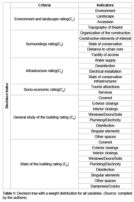
A series of “decision making ratings” have allowed us to study the relationship between the characteristics of the building and its adaptability for reuse, establishing six types of criteria and analyzing 32 indicators (Table 1). In the decision-making process, either an individual or group has to choose between two or more alternatives. These decisions can then lead to solutions of great importance; therefore, it is vital to give them the consideration they deserve.
When problems with decision-making are considered within in a project, in the majority of cases, the problems are multi-criteria. As we are responsible for these problems, the decision making is therefore focused on this approach, making room for Multiple Criteria Decision- Making (MCDM), which considers a range of options (continuous or discrete), different criteria or perspectives and the integration of different factors that are successfully included in the evaluation process. The weight of each criterion is usually previously defined, which is what adds weights to its criticism when speaking about the subjectivity of the approach.
In the MCDM, it is common place for certain aspects to be more relevant to the decision-maker than others. To establish a sound strategy and make correct decisions, it is advisable that the criteria, their relative importance and, in many cases, the indicators are chosen by managers or specialists in their field. Th w1, w2, ..., wney have to define the aspects they consider to be the most important and the general lines of improvement that they have to follow. In this way, it is possible to avoid the decision tree reflecting the position of conflicting parties by placing too much emphasis on certain aspects that are beneficial for some and detrimental for others.
Due to the nature of the present decision-making approach, a finite set of options, the decision based on the diverse nature or attributes of the options with regard to the relevant decision-making criteria, are applicable to multi-objective methods. Amongst these methods, the Analytic Hierarchy Process (AHP) method can be found in the literature [49,50]. The Analytic Hierarchy Process (AHP) method, having a profound impact at a theoretical and practical level, was put forward by Saati in the 1970’s. This method comprises the hierarchy tree of decision making, where the first level deals with the main objective of decision making, the second and subsequent ones with the criteria and the final one with the alternatives and possible solutions. For this method to be employed, a great deal of interaction with the main decision-maker is required, in a way that value judgments can be provided at each of the defined hierarchical levels. These judgments involve comparing values in pairs, leading to the provision ofn·(n-1)/2 value judgments about the relative importance of criteria as well as alternatives. The decision-maker establishes value judgments through Saaty’s numerical scale [49] from 1 to 9, comparing in pairs both the criteria and the indicators.
In this way, a matrix can be built which expresses the relative importance of each indicator selected in rows in relation to the rest of the elements in columns. The decision matrices obtained are squared n x n, n being the number of requirements, criteria or indicators that are being assessed as can be observed in Equation 1. For example, the comparable element in 12 represents the preference for element one over element two. Additionally, it follows that it is a reciprocal matrix as 
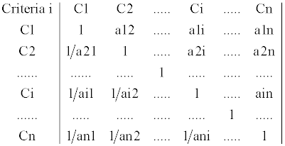
Equation 1.Decision Matrix [A].
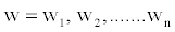
From each comparison matrix resulting from each uniform block (requirements, criteria and indicators), the eigenvector for this matrix (Equation 1) defines the weighting for each of the requirements, criteria and indicators used, defined as vector
→
The eigenvector is associated with the highest eigenvalue for each decision matrix and represents the ranking or order of priorities. Apart from this, the eigenvalue is a measure of judgment consistency and proves the correct assignment of the preferences. Thisconsistencyimpliestwofeatures: transitivity and proportionality. The first feature shows that the order relations between the elements should be respected if A>C and C>B, so logically A>B. The second feature represents the proportions between the orders of magnitude for these preferences. For example, if A is 3 times greater than C and C is 2 times greater than B, then A must be 6 times greater than B and this would be a 100% consistent judgment.
For the application of this method, the different elements need to be structured in a hierarchical way. In the present study, the first hierarchical level corresponds to the Building Decision Index, the second to the Criteria and the third to the Indicators.
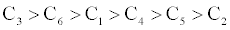
If we take the second level of our decision tree and order the six criteria being considered in decreasing order on the basis of their influence on the refurbishment of the construction, it can be presented in the following way:
Next, establish a value function using a measurement scale, such that the numerical system is a scale representation of the relationships between criteria.
The relative weights obtained from the six criteria considered are:
w = (0.41, 0.20, 0.14, 0.10, 0.08, 0.07)
A weighting consistent with the structure obtained by applying Saaty’s AHP method [49]. To obtain the Decision Index of the construction, the indicators pertinent to each criterion are valued. The value of the criterion is subsequently obtained, and finally, the Decision Index of the construction is obtained:
- The value of the indicators is obtained through quantification according to the values indicated in the field data questionnaires.
- The value of the criterion is obtained from the value of the indicators pertinent to the same criteria, multiplied by its respective weights, leaving a hierarchical tree like Figure 5.

Figure 5: Decision tree with a weight distribution for all variables.(Source: compiled by author).
To obtain the Decision Index of the construction, the indicators pertinent to each criterion are valued.
The GIS-based model developed by the present authors [43] in addition to storing information about the absolute location of the elements (georeferencing) in the system, make possible to calculate distances and areas, maintaining spatial relationships between them, i.e., it puts buildings into groups by type, state, age, location use, etc. This ability is particularly relevant at the resource exploitation phase as it enables us to classify buildings according to attributes. By marking a building on a map, one can see the information about it that is available in the database.
Figure 6 is an example of an identification file and how it is located in digital orthophotography. As shown, the screen is divided into three sections: the top, where the tool bar appears; the left hand window, which contains the layers we have created (villages, mills, traditional buildings, oil presses, livestock trails, paths, tracks, ordinary roads, motorways, riverbeds, rivers, buildings, population, and orthophotographs), which can be activated and deactivated at will; and the main window, where orthophotographs and the activated layers can be viewed. Identification files also appear in the main window, as does the graphic window of each building when we click on its icon in the orthophotograph. Although the identification files of rural buildings developed until now are diverse in terms of criteria and attributes, in the present study, the guidelines established by Fuentes and Cañas [11]have been followed, making up brief files of two pages. These files are easy to complete using drop down menus and are simple to computerize, based on the principle of progressing from general to detailed information. However, at present, it is not possible to prepare general identification files that could be applied to different areas and for different types of buildings, as noted by [11], because extrinsic variables depending on the morphological characteristics of the building and extrinsic factors related to the external context differ enormously between coastal and inland areas. It is possible to standardize the minimum variables that a rural building identification file should consist of. Through the application of the AHP method proposed by Saaty [49]as a weighing method, a linear, weighting and additive model that combines all of the factors in one unique global assessment can be obtained. This is based on the MCDM process described in the methodology section, for which values have been assigned to the coefficients of the linear expression that reflect the relative importance of each factor.

Figure 6: GIS detail, linking the identifying file of a wool factory, after clicking on its location in the orthophotograph of the area. (Source: adapted by the author).
Ultimately, the problem of decision-making in the assessment of potential refurbishment and/or reconstruction of rural buildings lies in creating a suitable system that shows the relationship between the multitude of factors impacting the possibility of refurbishment and, from this, to obtain through parametric adjustment a value function that is a good approximation of the same. Finally, combining all of the partial assessments, a unique mathematical assessment function can thus be obtained that could be supplementary and determine if the variables are independent.
For the evaluation of the refurbishment and/or potential for reconstruction of selected buildings, the present study was applied to 52 samples, after 9 of the initial 61 were rejected as a result of their being in very bad condition or in ruins. The 52 samples principally differed between 4 main types of construction: manor houses, farmhouses, water mills and oil-mills.
In Figure 7, the Decision Index of all of the analyzed constructions is presented, globally depicting the fluctuation of values in the set. The buildings with a lower Decision Index and, therefore, high priority in the reuse order are agro-industrial buildings, mainly oil presses, and to a lesser extent, if they are located near rural enclaves, water mills. As mentioned previously, this result is due to the evolution of productive human activities that tend to be located and developed in more functional and modern buildings. This has led to the abandonment of buildings associated with traditional economic activities, as they have become obsolete because of major changes in production systems, causing a rapid loss of traditional agro-industrial buildings.

Figure 7: Reutitilization rating of all the analyzed constructions. (Source: compiled by author).
It is important to highlight that buildings can be divided into groups by their attributes. The GIS provided selection criterion, for example, “mills with easy access”. Then, the layer “mills” can be selected at the top of the window and the code “ACCESS = Easy” is entered. The application will then automatically choose a color, light blue in this case, for all of the buildings that fulfill these conditions (Figure 8). This result demonstrates how useful the GIS are at characterizing and selecting particular buildings based on the specific characteristics of our search.

Figure 8: GIS detail, carrying out a search by attributes of the mills, according to the criteria for easy access water mills, which are shown in light blue. (Source: compiled by author).
Another application using the present GIS-based model is the statistical processing of information. If the attribute table of a subject or layer is opened, the attributes to be statistically processed can be selected. For example, we can generate a graph showing traditional buildings according to their state of repair. In this case, as we are dealing with qualitative attributes, it is necessary to provide numeric values to each qualitative criterion established for the state of repair of the buildings. From this statistical processing, we can obtain a report showing the results (Figure 9).

Figure 9: Report on the mills, according to their type, location and surroundings. (Source: compiled by author).
Finally, the developed GIS-based model enables us to find locations by SATNAV. If we link a sufficiently powerful laptop, PDA or similar tool to a SATNAV aerial, it is possible to establish our location on the screen and devise a possible route for users wishing to visit any of the traditional buildings under study.
Although authors such as García and Ayuga [9] argue that GIS techniques are not strictly essential to catalogue rural buildings, Fuentes [12], Hernández et al. [33], Ford et al. [35], Ford et al. [36] and Martín et al. [37] suggest using GIS to catalogue historical and geographical data for the analysis of vernacular architecture. Therefore, based on the results obtained, we found GIS to be extremely useful in cataloguing rural architectural heritage. As claimed by Carrera [14], it is clear that we can enter different layers of information that are independent but closely linked to the location of a building, in addition to introducing an architectural approach. This method could also add ethnological, artistic information about places, assets or activities that contain relevant forms of cultural expression and ways of living, providing a tool that helps to coordinate different administrations involved, such as the various ministries, universities and local authorities, thus helping to disseminate valuable results for the tourist trade promotion of this heritage for next generations.
As shown in the present Review, during last years it has been produced a change in touristic demands. It is originated by a change in mind and the possibility to get more time to spend in idleness. Consequently, the local and regional administrations have tried to increase the touristic offer through the proposal of alternate tourism to that the conventional model of sun and beach.
This touristic offer in Almeria province, for instance, has been the way to try the recovery of interior’s villages, clearly in economic disadvantage as compared to the coast’s villages, which have traditionally been the receivers of tourism. Inside this new mode, all the spaces are potentially considered as tourist trade, although it must be taking into account and to be conscientiously. To avoid any degradation of the environment and states of saturation, it must do a sustainable recreation use of these spaces.
An alternative option of this new offer are several touristic services, such as gastronomy of home-made food prepared using natural local products, generally of own crops; agro-tourism in farms; sport tourism, because the offer is located in natural landscapes which are favourable for several sports: trekking, puenting, canoeing, horseback riding, climbing, etc. In summary, all series of activities which in the traditional model (sun and beach in Almeria province) have not offered to the tourist and during last years, they have claimed.
The proposed methodology provides an efficient method for the inventory and characterization of the buildings in a particular area as an example (Almanzora, Almería province, Spain) based on the GIS. This becomes a working tool which enables us to add new data and to analyse the traditional rural buildings, in such a way that we would not just make the public aware of the region and its potential for tourism, but we would also facilitate the work of devising a possible route for users. Thus, it is to aid for a better development of tourism and promotion of the area, producing a catalogue of rural buildings which will help the management in their reuse or restoration or both by public organizations, or by any private individual interested in doing so. The application Microsoft Excel was chosen as a tool for the construction of a database. Because it is a program for the creation and administration of databases of use every day, it allows greater accessibility for all users in the management of the database.
The refurbishment of traditional buildings in a region entails the appropriate dissemination that can reach everyone. Nowadays, technologies such as the Internet as a tool enable us to make readily available to users, vast quantities of information and data in real time. As a proposal for future research work, it would be a good idea to link the database of the GIS developed elsewhere [43] to a website, as well as being able to download applications such as SATNAV onto a portable device. Doing this, it would be disseminate the catalogue of the traditional buildings of a region, as well as the possibilities of reusing them, especially with reference to their state of repair, refurbishment budgets, quality of the landscape, manpower services and help available for their refurbishment.
All these aims are addressed for a better sustainable tourism development [50].
The financial support of Andalusian Regional Government (Junta de Andalucía) to Research Groups AGR 107 and TEP 204 is acknowledged. The authors acknowledge the Editor J. Tourism Hospit. for your kind invitation to publish in that Journal.