Journal of Geology & Geophysics
Open Access
ISSN: 2381-8719
ISSN: 2381-8719
Editorial - (2014) Volume 3, Issue 3
The relevance of natural disasters such as droughts, floods and its impacts is well recognized. Socio-hydrological vulnerability studies have shown that the tropics of South America, Africa, Asia and Australia could experience a significant change in the frequency of occurrence and the intensity of natural disasters and they have a multidimensional effect on humanity in terms of several socio-economic parameters like agriculture, human health, sea level rise, scarcity of labour, disease prevalence, etc. Natural disasters are expected to impact livelihood and their occurrence will further aggravate poverty levels and sustainability of livelihood means in the years to come. The adversities resulting from natural disasters emphasize the importance of strategies needed to cope with the impacts. Unless well-thought strategies are implemented, they can result in a far reaching consequence and cause severe impacts on societies and livelihood especially among the natural resource dependent communities. Managing socio-hydrological vulnerability and enhancing resilience against natural disasters are the major pressing issues particularly among the developing tropical countries of the continents. However, the impacts, socio-hydrological vulnerability and capacity to adapt to these changes differ with time and space. For the same reason, international and national organizations, viz., United Nations Frame work Convention on Climate Change (UNFCCC), World Meteorological Organization (WMO), United Nations Convention to Combat Desertification (UNCCD), etc., are partnered to formalize plans to minimize the impacts.
Natural disasters and climate change is a global phenomenon which can be adopted and mitigated only through the unified action of the people across the globe. The issue surrounding climate change and its impacts human health, patterns and the intensity of the precipitation, water and the food supplies, energy supplies and the viability of the natural system will be affected as the earth’s climate continues to change [1]. Many of these changes are the irreversible and will shape generations to come. It is therefore vital to engage and mobilize today’s young minds to create innovative and the multidisciplinary answers to the many potential problems, to bring them together and promote productive and the informative discussion and to share each other’s thoughts, foster ideas and the establish connections can also be the best seen as interactions and the learning between generations each learning from the one another [2,3]. This type of research work consider semiarid region, which is experiencing a reduction of water availability due to changes in the climate [4,5] as well as increase in human water demand for urban supply, irrigation, and other purposes. As such, these regions are broadly representative of water-scarce regions globally those are facing increasing threats to water security [6].
One of the most important impacts of natural disasters and climate change occurs in water resources availability. Surface water and groundwater recharge may be directly affected by change in rainfall and increase in air temperature that causes higher evapotranspiration rates [7]. A direct consequence of changes in stream flow regime is the impact on water supplies. This is expected to lead to decreased water quantity available for different uses, especially to guarantee food supply for population in the arid and semi-arid tropics [8]. Natural disasters and climate change may also affect the function and operation of existing water infrastructure as well as water management practices [9]. Conversely, adaptive water management through forward-looking planning and operation of infrastructure coupled with flexible demand management represent important strategies to face climate change and variability [10,11]. Social impacts refer to all changes in the way people live, work, related and organise. More concrete, social impacts concern poverty, loss of life, health effects, loss of community cohesion, loss of time, changing attitudes, impoverished neighbourhood, etc… But social impacts are difficult to quantify in monetary terms and are often not estimated extent [2,3]. However, several studies, like the wide impact-survey in Scotland and the survey on natural disasters experience in Belgium, have concluded that natural disaster victims experience intangible impacts as being even more severe than tangible impacts [12].
Understanding the concept of socio-hydrological vulnerability, its extent, mapping, formulating vulnerability functions enabling risk impact assessments and the gravity of its dynamics at the levels of significance are needed before natural disasters management planning can be put into action [13]. These exercises will aid in recognizing, prioritizing, planning and channelling the resources to improve the capacity to adapt [11]. Furthermore, the existing constraints in financing the adaptation apply equally to all regions. So prioritizing, the regions need special attention and one should take into account the socio-hydrological vulnerability and impacts caused by climate change and natural disasters (drought and flood).
Socio-hydrological vulnerability research will give a brief of the existing approaches that focus on socio-hydrology and impact assessment aid to characterize and identify regions, sectors and communities which are at risk for socio-hydrological vulnerability currently and in the future [14]. It will also discuss the limitation, constraints and pre-requisites in these approaches and highlights the importance of micro level information to have a more realistic understanding of impact and socio-hydrological vulnerability through illustration. Socio-hydrological vulnerability will provide a guiding framework for devising action plans to improve adaptive capacity among vulnerable populations. For this type of research, the sociohydrological vulnerability index incorporated not only the frequency and intensity of hazard events such as floods, drought conditions, and natural disasters, but also the gradual changes in mean temperature and precipitation. Socio-hydrological vulnerability research will estimate the natural resources of the study area and will be effective for evaluating natural resource mapping and their proper management for future utilization. This type of research work will entails the maximum utilization of existing natural resources to reduce regional imbalances, promote sustainable development and at the same time ensure the protection of fragile eco-environment [15].
The main aim of socio-hydrological vulnerability research must be detect the spatial and temporal patterns of socio-hydrological vulnerability due to land use/cover, hydrology and socio-economic changes and to get a deeper insight in the mechanisms of these changes and to contribute to the ongoing debate about the causes and consequences or actual regional condition in arid and semi-arid regions by:
(i) Build relationships with stakeholder communities to develop a common understanding of their values and what they identify as threats to water security,
(ii) Collecting reliable data on vegetation degradation, deforestation rates, encroachment of agricultural land, silt deposition in river, flooding, droughts and patterns in the different landscape settings,
(iii) Understand divergent perspectives on the definition of sociohydrological vulnerability and the major driving forces for future insecurity,
(iv) Create a spatial and non-spatial temporal data base of geoenvironmental units, soil, slop, surface water bodies, drainage system and non-spatial like demographic data, occupation data and data related to amenities and general facilities, land and power availability (socio-hydrology) etc.
(v) Assess the social and natural science questions deemed important by stakeholder communities and draw on local knowledge to inform the research,
(vi) Identify problem and demands of the inhabitants and also distinguish and prioritize the factors that influence development of systems related to socio-hydrological vulnerability,
(vii) Study societal response to water stress and to economic and policy instruments for socio-hydrological vulnerability,
(viii) Determine the sustainability of these systems through indicators of economic, social and hydrology,
(ix) Inform policy options to address water uncertainty and impediments to effective water governance,
(x) Analysing the drivers and mechanisms of land cover change with ecosystem and there effect on socio-hydrological vulnerability,
(xi) Socio-hydrological vulnerability distribution and its dynamic change and cause of its levels,
(xii) The development of future land use scenario’s based on typical pathways of changes.
The focus of socio-hydrology is on observing, understanding and predicting future trajectories of co-evolution of coupled humanwater systems. In this sense, one could say that socio-hydrology is the fundamental science. Could we predict this? What will be the role of hydrology in any changes in the landscape including societal changes, and in return, what will be the impact of the societal changes on water cycle dynamics? Should such predictions be the business of hydrologists or social scientists? [16].
Arid and semi-arid regions such as North America, Northeast Brazil, Sahel Africa, Central-eastern Iran, North-west India and Central Australia are interesting because of the change in vegetation cover from dense vegetation to very little or no vegetation as desert area. In these areas living standard are highly variable due to different types of socioeconomic activities. There are different types of soil, vegetation cover, climate and relief along its extension. In these areas, many families live in the interior without access to water for drinking, cooking and hygiene. These families live far from the systems of water supply. During periods of severe droughts, these populations are supplied with water by tanker trucks and, in some cases, collecting water from springs and small reservoirs in daily journeys, generally made by women and children. In addition to this, wells and cisterns are the more common water collection and storage systems in these regions [16].
NASA climate and land cover datasets are useful to advance the climate change portion of the socio-hydrological vulnerability assessment. Specifically, changes in temperature and precipitation can measure using monthly NASA’s Modern-Era Retrospective Analysis for Research and Applications (MERRA) and Tropical Rainfall Measuring Mission (TRMM) 3B43 datasets, respectively. The satellite data can compare with the weather station data from the Department of Hydrology and Meteorology in these regions. The socio-economic data can obtain from the Statistics departments to measure the social vulnerability of the population. Historical records of climatic disaster events can acquire from Disaster Information offices to measure exposure to climatic disasters. Land cover maps such as Landsat 7 can useful to identify high-density urban areas prone to the urban heat island effect, and areas prone to landslides and natural disasters (Figure 1).
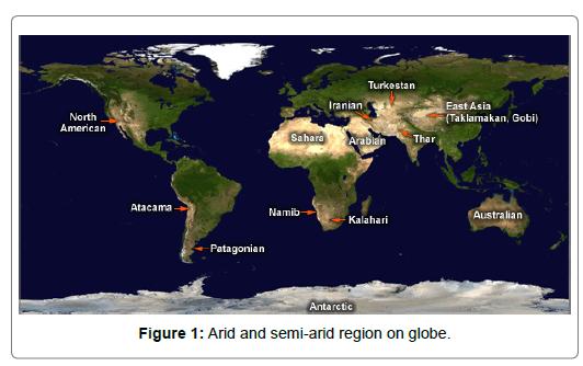
Figure 1: Representative photomicrograph of histopathological features in pulmonary necropsies.
The datasets should obtain and reviewed with literature review for quality and completeness. Indicators should define as a variable that quantifies and characterises the level of vulnerability or resilience in these areas. The index must be consequently composite of the indicators that summarises overall vulnerability to natural disasters, social factors, hydrological and climate impacts.This type of research work must be focus on data analysis and model building in order to develop the socio-hydrological vulnerability index by following stapes:
? Literature study and compilation of past and present-day land cover maps for Socio-hydrological vulnerability evaluation using visible and microwave remote sensing multi-temporal and multispectral satellite imagery.
? Collection of socio-economic, population, environmental and hydrological data for socio-hydrological vulnerability estimation. Also comprehension of the mechanism of sociohydrological vulnerability – influencing parameters, special attention on biomass, hydrology and social communities.
? Identification of the main socio-economic, bio-geophysical and socio-hydrological drivers for land use change with ecosystem and there effect on socio-hydrological vulnerability.
? And in last develop future socio-hydrological vulnaribility scenarios and evaluation of possible management strategies.
Medium and high resolution multispectral satellite imagery (ASTER, AMSR-E, LANDSAT, IRS and SPOT) must be used to compile land cover maps for these areas. The developed spectral signatures should be used to identify upland fields, forest, scrubland, rangeland, surface water body, potential ground water zone, and degraded areas [4,5]. For calculating socio-hydrological vulnerability, at least fifteen factors such as elevation, slope, accumulated temperature, flood index, drought index, land use, vegetation, soil, geology, geomorphology, water-soil erosion, socio-economic activities, population density etc. must be use. Reference data for ground calibration and validation would be collect by means of GPS-measurements in representative landscape types. Additional land cover data from available aerial photographs and topographic maps are useful to calibrate and validate the classification procedures in small test areas. These results will allow analysing the spatial and temporal patterns of land cover and socio-hydrological vulnerability change in these regions (Table 1).
| Component | Indicator |
|---|---|
| Exposure | Deaths per 100,000 inhabitants (climate-related disasters) |
| Losses per GDP in % (climate-related disasters) | |
| Number of droughts | |
| Number of floods | |
| Number of storms | |
| Sensitivity | Land cover |
| Forest cover | |
| Rain-fed agriculture | |
| Cereal yield (crop production) | |
| Adaptive capacity | Water access (rural) |
| Water access (urban) | |
| Paved roads | |
| Governance | |
| Population growth rate | |
| Population below poverty line | |
| Vulnerable employment | |
| Rural population |
Table 1: Possible components and indicators which, useful for the vulnerability index.
A balanced weight approach [17] must be used in this index, assuming that each component contributes equally to the index, regardless of the number of indicators under each component. To do this, the component score must be divided by the number of indicators. The weight scheme can be adjust to reflect the perceived importance of specific factors. The application of subjective weighting on the one hand give us some indication of how the relative importance of different factors might vary with context and can also tell us how sensitive sociohydrological vulnerability ratings will to perception of vulnerability in the expert community. Alos follow on following basic factors, which are affect on study area vulnerability:
a) Natural impact:
• Climatic impact: drought index, rain fall, wind, temperature,
• Topographic impact: slope, elevation,
• Physical impact: geology, geomorphology, soil, vegetation, land use/cover, hydrology,
b) Environmental impact: hazards, surface and ground water, watersoil erosion, atmospheric composition, biogeography and biodiversity,
c) Human impact: road density, population density, socio-economic characteristics.
Indicators must be select based on the statistical analysis. Multiple indicators should select to represent each of the three major components of socio-hydrological vulnerability (exposure, sensitivity and adaptive capacity). If no statistically significant relationship could be ascertained between a candidate indicator and socio-hydrology, the indicator must remove from consideration. The indicators should also taste for autocorrelation. Further, selected indicators use to calculate the sociohydrological vulnerability index as outlined below. The results of the calculation will map on a Geographic Information System (ArcMap) to determine the geographical distribution of socio-hydrological vulnerability; the results should subsequently compare with statistical results at the global level.
Each indicator should measure on a different scale (or different units), so it`s necessary to standardise them. In order to carry out the conversion, the values should index and represent as a percentage of the maximum for that indicator:
Subsequently the indicator values add to obtain the value of the component:

Where n is the number of indicators for a particular component.
Component value should similarly normalise, such that the maximum value for each should 1. The resulting normalise values would then multiply to obtain the index score:

The index score should also normalise with 1 being the maximum value. The results of the calculation should use to express relative sociohydrological vulnerability. Values associated with the model would divide into five different categories using the quintile method, with each range cumulatively representing 20% of the maximum vulnerability.
Socio-hydrological vulnerability is a new area of research that integrates people and their activities into water science. This type of research is important in water scare areas such as arid and semi-arid areas on the globe. The main objective of this type of research is to develop a socio-hydrological vulnerability index in semi-arid region by combining remote sensing, bio-geophysical and social data. In general, vulnerability is expressed as a function of the exposure, sensitivity and adaptive capacity of a region to natural disasters and climate change effects. The heart of water security is the ability of water systems to meet changing human and environmental needs. Socio-hydrological vulnerability research ensures that decisions made about our water resources incorporate a range of values and perspectives about the meaning, value and use of water. Presently scientists bring an interest in human values, markets, social organizations and political institutions to the traditional focus of water science on climate, social and hydrology [18]. It is a reality that natural disasters (such as drought and floods) results in sets of socio-hydrological impacts starting with crop-yield failure, unemployment, erosion of assets, income decrease, poor nutrition and decreasing risk absorptive capacity, thereby increasing the vulnerability of the community. In addition, it is demonstrated that the severity of these social impacts is experienced differently and depends one hand on socio-hydrological characteristics and on other hand on people’s exposure and characteristics, which are respectively named bio-geophysical, hydrology and social vulnerability. Mapping socio-hydrological vulnerability patterns across space and time helps to identify socially and bio-geophysical vulnerable areas and assists with climate change adaptation strategies in areas to projected sociohydrological vulnerability.