Journal of Geology & Geophysics
Open Access
ISSN: 2381-8719
ISSN: 2381-8719
Research Article - (2015) Volume 4, Issue 1
A new simple and quick geophysical method for groundwater exploration in the crystalline rocks of Tudun Wada Kano State, Nigeria has been developed. A geophysical evaluation using Electrical Resistivity method for groundwater exploration at the study area was carried out which involved the utilization of Vertical Electrical Sounding (VES) technique with schlumberger array system. The study area is located within the sedimentary rocks, igneous, and metamorphic with alluvial as common types of rocks. The data acquired from six (6) VES stations using ABEM terrameter (SAS 300) was tabulated in a table which shows the resistivity, the thicknesses and the number of layers for each VES station. The data was analyzed using computer software called IPI2win, which yield an automatic interpretation of the apparent resistivity. The VES results revealed heterogeneous nature of the subsurface geological sequence. The geological profile sequence in the study area include the topsoil, weathered layer, fractured basement and fresh basement. The value for topsoil ranges from 16 Ωm to 550 Ωm with thickness varies from 1.45 m to 6.05 m. The weathered layer resistivity ranges from 14 Ωm to 541 Ωm and thickness of 5.70 m to 33.00 m. The fractured basement ranges in value from 189 Ωm to 785 Ωm with thickness ranges from 11 m to 20 m. The fresh or bedrock basement has a resistivity of 1011 Ωm to 3006 Ωm which move down infinitely. Therefore the depth of the bedrock from the topsoil or earth’s surface ranges from 2 m to 45 m.
Keywords: Fractured basement; Fresh basement; Groundwater; Sedimentary terrain; Topsoil; Weathered basement; Vertical Electrical Sounding (VES)
The need for the quality and availability of water resources has always been the primary concern of our societies especially in semiarid and arid regions, and even the areas with abundant rainfall such as tropical region. The problem of gaining an adequate supply of quality water is generally becoming more severe effect due to ever increasing of population, irrigation and industrialization. Due to this situation, surface water cannot be dependable throughout the year; hence other alternative is needed in order to supplement for surface water. The groundwater is the water lies under ground and it is the best quality fresh water which the world depend on its availability source. It is the water held in the sub-surface within the saturated zone under hydrostatic pressure below water table. The groundwater can be in the sedimentary terrain where it is less difficult to exploit or in the basement complex terrain in which it can be a bit difficult to locate especially in areas underlined by crystalline rocks [1].
Nowadays the used of geophysical techniques for groundwater exploration and water quality evaluations has increases due to rapid advances in computer software and other numerical modeling techniques. The use of Vertical Electrical Sounding (VES) has become very popular with groundwater prospecting due to simplicity of the technique. The purpose of electrical geophysical survey method is to detect the surface effects that produce by the flow of electric current inside the earth.These techniques have been used in a wide range of geophysical investigations such as mineral exploration, archeological investigation, engineering studies, geothermal exploration, permafrost mapping and geological mapping.
Electrical methods are generally classified according to energy source involved that is either natural or artificial. Those under natural source method include self-potential (SP), telluric current and magneto telluric while those under artificial source methods are resistivity, electromagnetic (EM) and induced polarization (IP) methods. This present research used one of the artificial methods, which is the use of electric d.c resistivity method using an instrument called ABEM (SAS 300) terrameter which were taken using schlumberger array.
Mohamed A. Sabet carried out similar experiment to investigate the occurrence of groundwater in the coastal plain region of southeastern Virginia North Carolina, as indicated by the results of 45 Vertical Electrical Sounding (VES). These soundings were taken with schlumberger array with a maximum separation of 8000 feet between the current electrodes. The results of the VES data were interpreted through an automatic computer interpretation program, and by the curve-matching method.
Ariyo and Banjo [2] used the same method to study groundwater zone in a sedimentary terrain of Ilara-Remo, southwestern Nigeria. Their investigation involved the utilization of vertical electrical sounding (VES) technique with schlumberger array system; applied in ten (10) stations and the results were interpreted using the spatial curve-matching method and computer assisted iteration technique.
Fadele et al. [1] also used vertical electrical sounding (VES) for groundwater exploration around Nigerian College of Aviation Technology, Zaria Kaduna State, Nigeria. Their study used schlumberger arrangement in fifteen (15) VES stations and the resultant data was analyzed using computer software (IPI2win) which gives an automatic interpretation of the apparent resistivity. Vertical Electrical Sounding (VES) has been put to effective use in many earlier groundwater studies and found to be extremely successful. In the present study, the Vertical Electrical Sounding (VES) using schlumberger array were carried out at six (6) VES stations. The study used current electrode spacing of 1/2AB=100 M, in which the potential electrode separation MN has maintain its order of increment. The research was carried out to study the subsurface geology condition and the hydrological condition of the Tudun Wada area with the following objectives:
To identify the thickness, resistivity value of sub-surface layers; todetermine the hydrological conditions of the area and to identify a suitable places for boreholes location within the study area.
The field procedure used Vertical Electrical Sounding (VES) using schlumberger array which carried out at six (6) VES stations. The orientation of the profiles was maintained a regular direction of north-south, with the current electrode spacing of 1/2AB=100 M. The Schlumberger array consists of four (4) collinear electrodes. The outer two electrodes are current source electrode and the inner two electrodes are potential (receiver) electrodes (Figure 1). The potential electrodes are installed at the center of electrode array with a small separation, typically less than one fifth of the spacing between the current electrodes. The current electrodes are increased to a greater separation during the survey while the potential electrodes remain in the same position until the observed voltage become too small to measure. The instrument used for this survey is the ABEM terrameter (SAS 300) which is the modern instrument in which the resistance readings at every VES point were automatically display on the digital read out screen and were jotted down in the book provided during the survey.
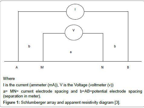
Figure 1: Schlumberger array and apparent resistivity diagram [3].
The advantages of the Schlumberger array are fewer electrodes need to be moved to each sounding and the cable length for the potential electrode is shorter. Schlumberger sounding generally have better resolution, greater probing depth, and less time-consuming field deployment then the wenner array. The disadvantages are that long current electrode cable is required, the recording instrument needs to be very sensitive, and the array may be difficult or confusing to coordinate amongst the field crew [3].
Study area
The study area located at TudunWada, underlocal government Kano State, Nigeria or located at 11°151N latitude and 8°241E longitude; covering a total area of 1,204 km2 (465 sq mi) with a population of 231,742 as for 2006 census. The area experiences a tropical climate having rainy and dry seasons. Rainy season begins in April/May and ends mostly in October while dry season prevails for the rest of the year. The mean annual rainfall is 785 mm with a relative humidity ranges from 20-70% and the mean annual temperature varies from 21°C to 27°C
The geology of the area comprises three groups of rocks namely migmatites and gneisses, derived from Birr main and sedimentary rocks through high grade metamorphism and granitization [4]. As Tudun Wada is one of the 44 local government of KanoState, Nigeria Mohammed indicates that the aquifers of the basement complex area of Kano State are the weathered and fractured rocks in which groundwater exist under water table condition, which lies at a depth generally less than 20 m and the maximum depth of boreholes rarely exceeds 60 m. The hydraulic conductivity of the aquifer ranges from 0.039 to 0.778 m/d with an average of 0.0330 m/d.
With respect to the hydro-geologic, the aquifers in Tudun Wada are generally overlaid by igneous rock, metamorphic rock and some consolidated alluvium layer which is built of clay mixed with sand in some areas especially near the river area. The main limestone is found in the southeast of the town and at the northeast. The center is consisting of granite and some metamorphic rocks. In the southwest was limestone as the major overlaid in the basement.
The Vertical Electrical Sounding modeling carried out at six (6) VES stations was used to derive the geo-electric sections of various profile; which indicate the existence of mostly four geologic layers in the study area in each VES point were the survey was carried out. This comprised the top soil, weathered basement, fractured basement and fresh basement rocks. The top soil consists of sandy soil with some gravel with resistivity range from 16 Ω to 550 Ω and thickness of range from 1.45 m to 6.05 m. There is some small content of clay soil in some VES stations such as inthe location near the river that is southeast of the town and northeast which were referred as VES1,3 in the southeast and VES 2 in the northeast with low resistivity values and high content of moisture, identified by clay in the layer. The weathered basement which is the second layer has resistivity ranges from 14 Ω to 541 Ω and the thickness varies from 5.70 m to 33.0 m which is the highest layer in terms of thickness and it is in the VES station 4, which is more appropriate for drilling boreholes, due to a probable high water contains. Approximately all the places in Tudun Wada area are suitable for boreholes installation due to their good land and shallow aquifers. The fractured basement is the third layer has a resistivity ranges from 189 Ω to785 Ω and the thickness varies from 11 m to 20 m. The last layer is called fresh basement which has resistivity varies from 1011 Ω to3006 Ω which move down infinitely in depth. Therefore the depth of bedrock from topsoil or earth’s surface ranges from 2 m to 45 m respectively.
Table 1, illustrates the results fieldwork that was carried out during the experiment in the Tudun Wada area of Kano State Northwest, Nigeria. The geometric factor, K, were determine for all the electrode spacing using the relation;  , for Schlumberger configuration in which MN=2b and
  . The results obtained were multiplied with the resistance values to obtain the apparent resistivity, ρavalues (Table 2). By the use of IPI2win software the result of apparent resistivity and electrode spacing was plotted in a log-log scale to obtain VES sounding curve. Figure 2 is the sounding curve and itsmodel.
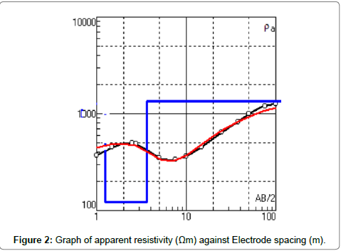
Figure 2: Graph of apparent resistivity (Ωm) against Electrode spacing (m).
| VES stations | Thickness (m) | Layer Resistivity (Ωm) | Number of layers |
| 1 | 1.70 30.01 11.00 - |
40.00 487.00 221.00 1011.00 |
4 |
| 2 | 1.85 28.40 17.50 - |
65.00 530.00 189.00 3006.00 |
4 |
| 3 | 1.45 33.00 20.00 - |
88.50 380.00 785.00 2453.00 |
4 |
| 4 | 6.05 14.70 18.80 - |
550.00 541.00 645.00 1456.00 |
4 |
| 5 | 2.05 5.70 13.50 - |
16.00 14.00 353.00 2343.00 |
4 |
| 6 | 3.75 22.30 - |
78.00 220.00 491.00 |
3 |
Table 1: The results of VES stations (1 to 6) of the study area are shown below.
| N | Ρ/Ωm | h/m | d/m |
| 1 | 40.00 | 1.70 | 1.70 |
| 2 | 487.00 | 30.01 | 31.71 |
| 3 | 221.00 | 11.00 | 42.71 |
| 4 | 1011.00 |
Table 2: Resistance values and their apparent resistivity.
Vertical Electrical Sounding (VES) technique carried out at six (6) VES stations in Tudun Wada local government area of Kano State Northwest, Nigeria revealed that; there are four layers mostly in the area by which among the six (6) VES stations only one station has three layers (station 6, at the western part of the study area). It is also seen that the probable stations more suitable for making boreholes were station VES 1, 3 in the southeast and station VES 2 in the northeast of the study area. However by considering the result obtained it is an indication that the study area has a good land for boreholes and other engineering and architectural activities, due to the features that enhance groundwater permeability and storage.
For safety measures, in the shallow aquifers which are ranges from 2 m to 45 m, the random dumping of waste products such as solid and liquid materials must to be avoided in nearby boreholes area in order to prevent waste contaminate to aquifer replenishment.
The authors would like to thank the Head of Geology Department of A.B.U Zaria in person of Prof. U.A Dambatta for his tireless effort of instructing how to use the equipments including the software. The data of this paper is a primary data, was obtained during the field work by the corresponding author. All data can be received upon request of the author.