Journal of Geology & Geophysics
Open Access
ISSN: 2381-8719
ISSN: 2381-8719
Image Article - (2023)Volume 12, Issue 1
In these recent times detailed investigation of top 30-50 meters of subsurface is needed for infrastructure, water supply, farming, waste deposits, construction, aquifer storage and recovery. Currently available geological methods are capable of imaging this subsurface zone. The towed Transient Electro Magnetic Method (tTEM) method is a ground based, transient electromagnetic system; it is designed for detailed 3D geological and geophysical mapping of shallow subsurface in range of 0 m 80 m at a high resolution, horizontally and vertically. This is a fast and cost efficient way in geological mapping. The detailed 3D data is obtained by the process of fast data repetition and it is done by giving small line spacing of 10-20 meters [1]. The mapping operation with this system has quickly to place and the whole operation is can be performed by two persons of field crew.
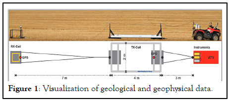
In these recent times detailed investigation of top 30-50 meters of subsurface is needed for infrastructure, water supply, farming, waste deposits, construction, aquifer storage and recovery. Currently available geological methods are capable of imaging this subsurface zone. The towed Transient Electro Magnetic Method (tTEM) method is a ground based, transient electromagnetic system; it is designed for detailed 3D geological and geophysical mapping of shallow subsurface in range of 0 m 80 m at a high resolution, horizontally and vertically. This is a fast and cost efficient way in geological mapping. The detailed 3D data is obtained by the process of fast data repetition and it is done by giving small line spacing of 10-20 meters [1]. The mapping operation with this system has quickly to place and the whole operation is can be performed by two persons of field crew. The tTEM-system consists of an All Terrain Vehicle (ATV), it is carrying the instrumentation and towing the receiver coil and the transmitter frame. The receiver coils and transmitter are mounted on sleds for a smooth ride over rough fields or terrain. The transmitter coil dimensions are 2 m × 4 m, and a zcomponent receiver is placed at 9 meters from the transmitter. It uses dual transmitter moment i.e. low and high moment. The subsurface layers of shallow and deep types are varied by measurement sequences information. This widely used for mapping raw materials, assessing aquifer vulnerability, and investigating contaminated sites. The specifications of the tTEM systems are dual moment toward TEM system, distance of offset configuration is 9.5 m, Depth of Investigation (DOI) is 50 m 100 m, drive speed is 4 m/s-5 m/s or 15 km/h-20 km/h, average daily production rate of farm fields is 100-250 hectares, peak current is 30 Amp.
The collected data by tTEM system is processed with the Aarhus Workbench software package, which is fully integrated. Aarhus Workbench is a unique and comprehensive geology software package for processing, inversion, and visualization of geological and geophysical data [2]. This software can handle the integrated steps involved in the process from raw data to the final visualization and interpretation of inversion models, this software also have dedicated processing modules and an integrated GIS platform. This can support electrical and electromagnetic data from both ground based system and air borne systems (Figure 1).

Figure 1: Visualization of geological and geophysical data.
Citation: Gupta V (2023) Towed Transient Electromagnetic Method (Item) In Geological Mapping. J Geol Geophy. 12:1065.
Received: 10-May-2022, Manuscript No. JGG-22-17430; Editor assigned: 13-May-2022, Pre QC No. JGG-22-17430(PQ); Reviewed: 27-May-2022, QC No. JGG-22-17430; Revised: 03-Jan-2023, Manuscript No. JGG-22-17430(R); Published: 10-Jan-2023 , DOI: DOI: 10.35248/2381-8719.23.12.1065
Copyright: © 2023 Gupta V. This is an open-access article distributed under the terms of the Creative Commons Attribution License, which permits unrestricted use, distribution, and reproduction in any medium, provided the original author and source are credited.